Locus Fast and useful Online/Offline map viewer for Android.
· This is also My Maps editor so Google Account permission is needed
· Contacts permission is for getting contact address on various places in app (adding point into database by contact address, etc...)
· If anything not work, send email
· If app crash, send log from logcat or Locus/logs directory
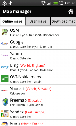
· Online maps (OSM, Google, Yahoo, Bing, OVI/Nokia, ... actually 37 types)
· Offline maps (SQLiteDB format, updated TrekBuddy TARed format)
· direct download Online -> Offline (defined area - rectangle, path, state).
· Google My Maps Viewer, Google My Maps editor (BETA)!
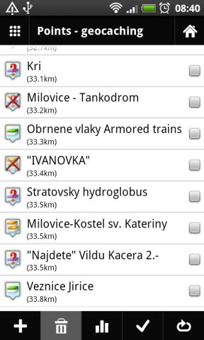
· POI handling => POI import into separated categories, viewing on map, basic guiding.
· support for Groundspeak PocketQuery
· Google Street View
· support for Bluetooth GPS
· work with c:geo, GPS Status
· quick and clean GUI
· and more
What's New in This Release:
· fixed some language troubles (import/export)
· full support for zipped files import
· better support for GPX files
· faster data importing
What's New in 0.9.21:
· fixed problem with adding categories
· rewrote a little start of app
What's New in 0.9.15:
· distance on screen during path creating
· improved handling with track styles. Now define style for import and record separately
· bug fixes
Like it? Share with your friends!
Supported operating systems:
Google Android 1.6, Google Android 10.x, Google Android 2.0, Google Android 2.1, Google Android 2.2, Google Android 2.3, Google Android 3.0, Google Android 3.1, Google Android 3.2, Google Android 4.0, Google Android 4.1, Google Android 4.2, Google Android 4.3, Google Android 4.4, Google Android 5.x, Google Android 6.x, Google Android 7.x, Google Android 8.x, Google Android 9.x
Similar Software:
AugSatNav Walk AugSatNav is an augmented reality navigation system which overlays walking directions upon a live video feed of the path or road ahead.
With AugSatNav there is no need to follow instructions or interpret maps - you can simply find your way by walking along the route highlighted by a bright white line
Art Places Art Places is a software application for the Android mobile operating system.
The application gets our position through the GPS in the mobile device and shows us our current location in the maps application. of maps
Metro LX Metro LX is a comprehensive guide to the Lisbon Subway providing:
A map of Lisbon Metro (subway) in landscape and portrait modes;
A route planner between stations;
A map route to station from your position;
And detailed information per Station.
What's New in This Release:
· Updated tariff (February 2012);
· Minor bugs fixed on tablets
CoPilot Live UK + Ireland (Android) CoPilot Live UK + Ireland (Android) - CoPilot Live is full-featured voice-guided GPS navigation with street maps of 1 European region stored on your Android phone. Includes 3D guidance, lane assist, speed limit warnings, safety camera alerts, planning mode.
Download maps via WiFi after purchase. Unlimited use after 10 days once Google order verified
BostonBusMap BostonBusMap is an application for Android phones. It uses GPS data provided by the MBTA to plot the real-time location of buses on a map.
What's New in This Release:
· GPS now turns on when you start the app to allow quicker location lookup times
Hollywood Star Maps Hollywood Star Maps - Welcome to Hollywood, California - Home of the world''s greatest stars! Search and find famous celebrity homes and locations in Los Angeles, California and make your next sightseeing tour all the more fun by driving yourself to the homes of the stars
CoPilot Live South Africa (Android) CoPilot Live South Africa (Android) - Get a CoPilot! The onboard GPS navigation app that makes every journey better
MapDroyd MapDroyd - Of course, today there are many Android application featuring street maps. Most of them are based on Google Maps, which means you've to enable your mobile device's network connection through a GPRS or Wifi connection
Google Maps (Android) Google Maps - Now you can get business locations, maps and directions while you're on the go. And it's all free.
· Navigation: Free, voice-guided GPS navigation system using GPS with Google Maps
· Places: Find nearby places and see hours, reviews, etc
yozi yozi is a navigation software for the Android platform. It uses digital topographic maps in well-known Ozi Explorer formats for navigation and doesn't require network access like built-in Maps application on Android
Other Software by developer «menion»:
Locus Free Locus Free - Fast and useful Online/Offline map viewer for Android.
· This is also My Maps editor so Google Account permission is needed
· Contacts permission is for getting contact address on various places in app (adding point into database by contact address, etc..

")


")


")

")

