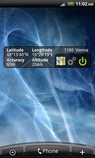
GPS Widget - This widget simply shows your current location in numbers. Latitude and Longitude are received from the GPS location provider or from the network location provider if GPS is not available.
The altitude is queried from open MapQuest API which yields in a more accurate result than receiving the altitude by GPS. So this widget is also interesting for hiking (altimeter).
Features:
· Display your current location in numbers
· Additional information (Street, City)
· Shows your altitude with high accuracy
Locked features (can be unlocked with some Good Karma):
· Share your location with friends via SMS, Email, etc.
· Different location formats are supported (Decimal Degrees, Universal Transverse Mercator (UTM), ...)
Note 1: To save battery power you should switch off the widget when you do not need it. You can force the widget to switch off automatically after some time in the settings.
Note 2: This is no GPS toggle widget. You can not turn on and off GPS. You simply get clear information about your current location.
To add widget press: Home->Menu->Add->Widgets->GPS Widget
If you like the widget, you can donate to the developer (it's free for you) and earn some Good Karma Points in the settings view!
The widget needs the following permissions because:
· Your location: it's obvious
· Network communication: query altitude, donation via Tapjoy
· Storage*: donation via Tapjoy
· Phone calls*: donation via Tapjoy
(*) You don't want to accept these permissions? Get "GPS Widget Pro" without the option to donate -> no "Storage" and "Phone calls" permission is required.
What's New in This Release:
· GPS satellite fix can be displayed
· higher accuracy (now 6 decimal digits)
· ornaments in background can now be removed
· Bug fix
What's New in 1.1.0:
· alternative location formats (UTM, etc.)
· display altitude in meters or feet
· Share location with others via SMS, Email,...
Like it? Share with your friends!
Supported operating systems:
Google Android 10.x, Google Android 2.1, Google Android 2.2, Google Android 2.3, Google Android 3.0, Google Android 3.1, Google Android 3.2, Google Android 4.0, Google Android 4.1, Google Android 4.2, Google Android 4.3, Google Android 4.4, Google Android 5.x, Google Android 6.x, Google Android 7.x, Google Android 8.x, Google Android 9.x
Similar Software:
FastToolBar FastToolBar - It is simple and easy controller:
-Sound control
-WiFi control
-Bluetooth control
-GPS control
One click and you can turn on/off this functions.
Simple and very convenient widget will not take you on the phone a lot of memory
Sygic: GPS Navigation Sygic: GPS Navigation - Sygic is the premium turn-by-turn GPS navigation app. Sygic boasts an intuitive interface: drag the map, pinch to zoom, change point of view using built-in compass and tap target square to choose action. Sygic is comfortable and safe: advanced routing is optimized for Real-Time Traffic
Run.GPS Trainer UV Run.GPS Trainer is the perfect tool for sports like running, skiing and walking. It uses the Global Positioning System (GPS) to record all of your training parameters like speed, distance and altitude.
Run.GPS Trainer UV is the successor of of the award-winning Run.GPS Trainer software and has tons of new features
VGPS (Vietnamese GPS) for Android VGPS (Vietnamese GPS) for Android was designed to use city street map on your ordinary mobile phone without the need of having GPS receiver or internet connection. VGPS does not require internal or external GPS receiver. However, if you have internal GPS receiver or external bluetooth GPS receiver, VGPS can work with your GPS receiver as well
GoPenS GoPenS is an OpenSource GPS application for Android phones, based on OpenStreetMap (OSM). OpenStreetMap is a collaborative map of the world. Therefore, one of the main functions of the application is to be able to record a trace and send it as a GPX to the OSM servers, and so edit the OSM Map
AugSatNav Walk AugSatNav is an augmented reality navigation system which overlays walking directions upon a live video feed of the path or road ahead.
With AugSatNav there is no need to follow instructions or interpret maps - you can simply find your way by walking along the route highlighted by a bright white line
Maps In My Pocket (MIMP) Maps In My Pocket - The main goal of this application is to allow its users to view maps, locate themselves, follow KML or GPX formatted tracks and getting directions from place to place.
What's New in This Release:
· New Icon
What's New in 1.4.3:
· Long press and long pinch concurrency on info bubble solved
TouringNavigation TouringNavigation - It is a navigation application program for the motorcycle and the bicycle, etc.
It is a navigation application for the motorcycle and the bicycle, etc.
This application displays the route guide, tracks, the mileage that has been passed, the running time , and the mean time velocity
Path Finder Path Finder is a free Android mobile app built at Paxcel Labs that records your GPS positions while you walk or drive and helps you track and record your routes making it easy to remember your way or where you parked your car or bike
GPS Signal Widget GPS Signal Widget - Do you get tired waiting for the GPS location to be available? With this tool you can check out the GPS satellites and the signal strength in just a nice 1X1 widget.
The spokes in the widget represents the satellites and the length of the spokes is a measure of the signal strength.
Enable or disable the widget by tapping on the widget
Other Software by developer «Wolfgang Knecht»:
not found
Comments on GPS Widget:
Comments not found
If you noted an error or download link is broken, please, report it via this page or use comments.
GPS Widget is compatible with your device Sprint Express


 for Android")


")

