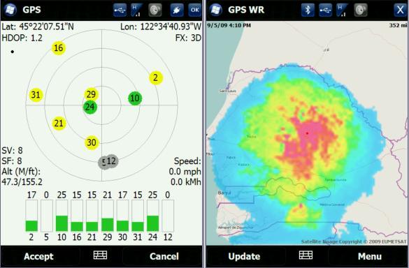
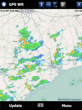
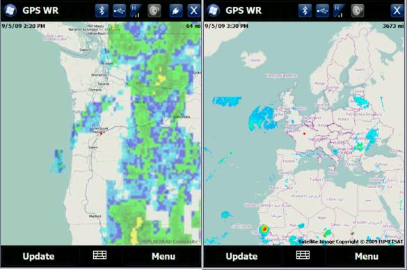
GPS Enabled Weather Radar is weather application that uses your built-in GPS to pull radar images from 3rd party weather services. You can view imaging in satellite or radar formats. It’s currently supported for North America, but it might be possible to add other locations with radar sites.
GPS Enabled Weather Radar Video Preview
GPS Enabled Weather Radar Features:
- Gets weather radar for current GPS location or using cell towers
- Ability to manually enter location
- Click anywhere on the map to move to that location
- Different views and zoom levels
- Animated radar loop
- Integrates with Showaco TitaniumWeather 4.2 PlugIn
New version 2.2.05
- Speed and stability improvements.
- Other minor fixes.
New version 2.2.02
- Added a version for WM Standard (non touchscreen).
- Other minor enhancements.
Like it? Share with your friends!
If you got an error while installing Themes, Software or Games, please, read FAQ.
Supported operating systems:
Windows Mobile 5.0 Smartphone, Windows Mobile 6 Standard, Windows Mobile 6.1 Standard, Windows Mobile 6.5 Standard
Similar Software:
VITO ActiveTrace VITO ActiveTrace is a sports oriented software specially designed to help you watch your sports progress. VITO ActiveTrace turns a Smartphone into your personal coach that accurately keeps detailed statistics for every trip and also records corresponding tracks. Just turn VITO ActiveTrace on, put your device in a pocket and concentrate on training
Turbo GPS Turbo GPS -The most flexible and precise track / offroad GPS you have seen. Available for both Windows and Windows Mobile
FON Access Points for Honduras FON Access Points for Honduras - FON offers you a new Points of Interest service (POIs). This allows you to download FONspots directly to your navigation device.
What does that mean? You can download a Points of Interest file directly to your navigation device
Navimote Navimote is an on-demand mobile phone-finder based on push technology. With Navimote you can enable others to retrieve your position in real-time
MobileTraveler Mobile Traveler enables you when you are traveling abroad (e.g. Japan) to find your way around there. It uses Google to find routes and enables pre-fetching parts of Google maps at home or any where you have WiFi or cheap data rates of your mobile telephone provider. Besides this it is especially useful when you are visiting Japan
FON Access Points for New Zealand FON Access Points for New Zealand - FON offers you a new Points of Interest service (POIs). This allows you to download FONspots directly to your navigation device.
What does that mean? You can download a Points of Interest file directly to your navigation device
FON Access Points for Ethiopia FON Access Points for Ethiopia - FON offers you a new Points of Interest service (POIs). This allows you to download FONspots directly to your navigation device.
What does that mean? You can download a Points of Interest file directly to your navigation device
OSMtracker OSMtracker is an application for Windows Mobile Pocket PCs and SmartPhones. The main features are track logging (gpx) and quick (voice) waypoint annotations when driving a car or on a bicycle. It also has a smooth scrolling map with heading indicator
FON Access Points for Jamaica FON Access Points for Jamaica - FON offers you a new Points of Interest service (POIs). This allows you to download FONspots directly to your navigation device.
What does that mean? You can download a Points of Interest file directly to your navigation device
SportyPal SportyPal is an easy to use intuitive application for your mobile phone. You activate it when you start your running, cycling, walking, rollerblading or similar exercise. In two simple clicks it will start to log and map your position, movement, distance, tempo and calories burned
Comments on GPS Enabled Weather Radar:
Comments not found
If you noted an error or download link is broken, please, report it via this page or use comments.
GPS Enabled Weather Radar is compatible with your device Sprint HTC Snap S511 (HTC Cedar 200)

")


.jpg)