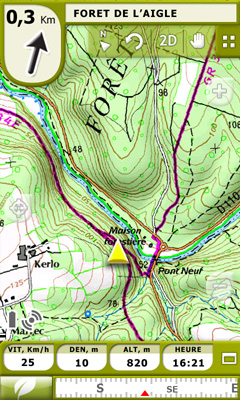
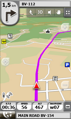
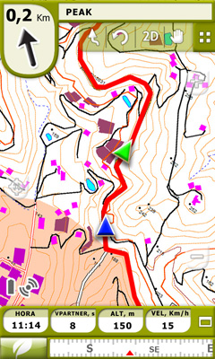
TwoNav for Windows Mobile - A dual navigation system (On-Road/Off-Road) to perform most of your outdoor activities (hiking, biking, skiing, geocaching, ...). TwoNav can also guide you when driving. A single solution for all your orientation needs.
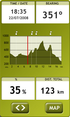
Load maps, tracks, routes and waypoints and get ready for your trip! - Save your performances by recording them as tracks (performance’s information is being controlled by more than 60 on-screen stats).
E-Roadbooks, data field alarms, Virtual Coach, Man Over board...It doesn’t matter which is your activity, TwoNav will cover all your needs!
· 15 days trial
Like it? Share with your friends!
If you got an error while installing Themes, Software or Games, please, read FAQ.
Supported operating systems:
Windows Mobile 6 Classic, Windows Mobile 6 Professional, Windows Mobile 6.1 Classic, Windows Mobile 6.1 Professional, Windows Mobile 6.5 Professional
Similar Software:
Map of Amsterdam / Netherlands for City Advisor Map of Amsterdam / Netherlands for City Advisor
Instructions:
1. Download the map (zip file)
2. Extract the files in /CityAdvisor/maps
3. Open CityAdvisor -> Maps icon -> Menu -> Refresh
4
Tube 2 Engine (Pocket PC) Tube 2 Engine (Pocket PC) - Transform your PDA into a fully scrollable detailed map of one of the worlds subway or metro systems.
See your journeys come alive with a superb animated display.
Save hours by automatically having the quickest routes to hand, with all the details you need including line changes, platform directions and accurate journey times
amAze (Samsung) AmAze is a first of its kind free navigation and local search service. It is free to download and use and it contains wide coverage of maps including aerial photo in Europe, North America, Australia and parts of Asia and Africa
Edinburgh Pocket A-Z map Edinburgh Pocket A-Z map - This publication has been designed for a Windows® Mobile-based Pocket PC (version 2002 or later) and The Pocket A-Z Viewer (included)
amAze (Motorola) AmAze is a first of its kind free navigation and local search service. It is free to download and use and it contains wide coverage of maps including aerial photo in Europe, North America, Australia and parts of Asia and Africa
Bing Bing -Maps, directions, and local listings for your mobile device.
Get local:
· Quickly find great local shops and restaurants, complete with ratings, reviews, hours, and directions.
· See movie show times and call to buy your ticket.
· Get the latest local weather forecasts
TrackMe TrackMe - Tool that stores GPS positions and uses that information to generate KML files that can be used by Google Earth or Google Maps for displaying realtime or prerecorded tracks.
The data can be stored locally on your PDA or remotely on a server. You can use my server (free of charge) for storing your data
MyTravelr Mytravelr is a set of tools designed to help on-the-go mobile users maximize their productivity and reduce the stress of trave.
1.0F3 version:
- Fixed bug: some cities DST issue.
- Fixed bug: Weather update from forecast screen.
- Added: Option for disabling Internet Network confirmation.
1.0F2 version:
- Added: Edit cities feature (Add/Update/Delete)
Leicester Pocket A-Z Map Leicester Pocket A-Z Map - This publication has been designed for a Windows® Mobile-based Pocket PC (version 2002 or later) and the Pocket A-Z Viewer (included). The map covers an area of Leicester, extending to Anstey, Cropston, Rothley station, Syston, Scraptoft, Oadby, Wigston, Blaby, Narborough, Leicester Forest East, and Groby (part)
MapsAligner MapsAligner - MapsAligner allows you to download large maps based on your GPS or with custom latitude and longitude points that you enter. You can use this to compose maps for your GPS applications. The program uses the Google.com maps server for the maps.
This program requires that you have both the 'BeanDLL
Other Software by developer «CompeGPS»:
TwoNav for Android TwoNav for Android - A dual navigation system (On-Road/Off-Road) to perform most of your outdoor activities (hiking, biking, skiing, geocaching, ...). TwoNav can also guide you when driving. A single solution for all your orientation needs
TwoNav for iPhone/iPad TwoNav for iPhone/iPad - A dual navigation system (On-Road/Off-Road) to perform most of your outdoor activities (hiking, biking, skiing, geocaching, ...). TwoNav can also guide you when driving. A single solution for all your orientation needs

")


")
")

")


