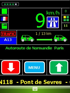
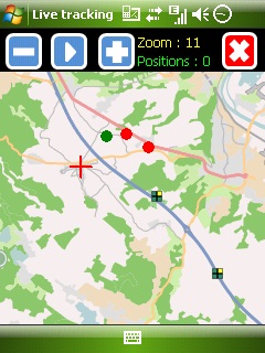
Mobbyway - Based on both internet mobile technologies and GPS, Mobbyway allows you to know easily, at any time, your relatives’ exact position on a map if they have accepted it and if they are connected to the network.
Mobbyway is also a help on the road network with a local alert system of a dangerous zone which is carried out with the network of members. Finally, Mobbyway will reference all the fixed radars in the countries where it is used and Mobbyway will indicate them to you.
Mobbyway was developed to allow:
- you to stay connected with your relatives wherever they are.
- your relatives to follow you visually and in real time.
- you to go back at any time to a place where you have already been on a specific date.
- you to travel safely on the road network thanks to the network members: The Mobbynautes.
- you to have a part in the world cartography OpenStreet Map
Like it? Share with your friends!
If you got an error while installing Themes, Software or Games, please, read FAQ.
Supported operating systems:
Windows Mobile 6 Classic, Windows Mobile 6 Professional, Windows Mobile 6.1 Classic, Windows Mobile 6.1 Professional, Windows Mobile 6.5 Professional
Similar Software:
Pocket PC Geocaching Tools Pocket PC Geocaching Tools - Many tools in one program to help you while you are geocaching.
What's included?
* Open GSAK databases directly
* HTML view
* Field Notes
* Hint decoder and decryption
* Several coordinate functions
* Solver
* Transformer (Text to Digits, etc
PictureGPSed PictureGPSed - PictureGPSed checks the camera storage folder for new pictures/videos and when detected places the current GPS tag at the end of the image/video and sends it via email with a Google.com map link. You can also view the images via a distance file viewer. You can also view and download a map of the pictures from Google.com
DocumentGPSs DocumentGPSs - DocumentGPSs can be used to make Pocket Word documents with a GPS tag as the sheet file name. Each time you make a sheet the document it is named the latitude and longitude of your GPS. You can store your files on the storage card. You can also view the Documents with Google maps.
This program requires that you have both the 'BeanDLL
FileGPSes FileGPSes - FileGPSes allows you to browse and execute the GPS tagged files and view them sorted in distance from your current GPS. You can also view and download the files placed on a Google.com map. This program uses "The Vincenty inverse formula for ellipsoids." (accuracy to within 0.5mm, or 0
TravelGoogling TravelGoogling allows you to use the GPS on your PocketPC to find 5,451 local stores and services in sorted via distance. Tap the button to start the GPS and when you get the lock tap the button to view the business directory. Tap on a business category to view local business listings. The GPS street information is from GeoNames
SportyPal SportyPal is an easy to use intuitive application for your mobile device. You activate it when you start your running, cycling, walking, rollerblading or similar exercise. In two simple clicks it will start to log and map your position, movement, distance, tempo and calories burned
GPS2Watch GPS2Watch - Add-on for smartWatchM that displays GPS information on supported Bluetooth watches. It simply uses smartWatchM "3rd party notifications", and connects to WM5+'s intermediate GPS driver, so no messing with COM ports. It should work with any device/GPS combination, if the GPS is external it must be set in WM's "External GPS" settings
ExerciseGPSs ExerciseGPSs - ExerciseGPSs uses the GPS on your PocketPC to view on a large display your walking/running/riding speed on a moving graph. You can use this to keep your exercise pace. NOTE: The program does not display/graph 0 speeds.
This program requires that you have both the 'BeanDLL.dll' file ** and ** the runtime files for Visual Basic on your PocketPC computer
GPSLockerer GPSLockerer keeps your GPS in your device active. When you tap the button the program will start the GPS and download the GPS data for your area. The program keeps the GPS active to allow for quicker fixes when you use another GPS program
DateGPSs DateGPSs - DateGPSs uses the GPS network to find the UTC date and time. The program shows the date and time in a 10 entry offset list. You can customize the times via decimal numbers for under 1 hour. The time offsets are saved to a file.
This program requires that you have both the 'BeanDLL.dll' file ** and ** the runtime files for Visual Basic on your PocketPC computer
Other Software by developer «Mobbyway»:
Mobbyway Mobbyway based on both internet mobile technologies and GPS, Mobbyway allows you to know easily, at any time, your relatives’ exact position on a map if they have accepted it and if they are connected to the network.Mobbyway is also a help on the road network with a local alert system of a dangerous zone which is carried out with the network of members


")
")