CacheTrack is a Java application for S60 mobile phones that reads files in the Geocaching.com-GPX-format and helps to find geocaches.
CacheTrack is a free application. You just have to visit a web page containing the latest about CacheTrack on your phone to unlock the application for 24 hours.
· Open GPX files which are compatible with Geocaching.com
· record of your tour
· export the recorded tour as a KML file to be viewed with Google Earth
· export waypoints as "Landmarks" e.g. to view them on Nokia Maps or use the "Navigate to" function of your phone
· create new waypoints
· waypoint projection
· view images referenced by the cache description
· view cache logs
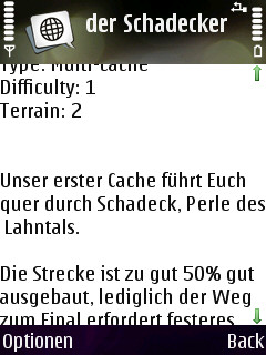
· view cache description
· view cache hints
· can use internal or external GPS receivers
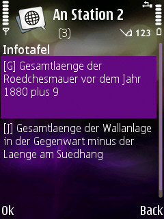
· automate the creation of waypoints based on instructions found in the cache description by the use of a so called "Solver"
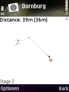
· view an Google Maps image showing the current waypoints
What's New in This Release:
· Can now read new and old Geocaching.com GPX files
Like it? Share with your friends!
Requirements:· Symbian S60 3rd/5th Edition
Supported operating systems:
Java ME, Java Nokia 240x320, Java SE 240x320
Similar Software:
FON Access Points for Palau FON Access Points for Palau - FON offers you a new Points of Interest service (POIs). This allows you to download FONspots directly to your navigation device.
What does that mean? You can download a Points of Interest file directly to your navigation device
Nokia Location Tagger With Nokia Location Tagger, you can automatically tag your location data to your pictures. As you take a picture, your GPS coordinates are saved to the EXIF header of the JPEG file. You can use this data later, for example, to locate your pictures on a map.
In the near future, we hope to make location tagging a seamlessly integrated part of your Nokia experience
Sports Tracker Sports Tracker is a GPS based activity tracker. It collects info such as speed, distance and time and automatically store them to your training diary.
Version 1.85 is of course a free version and works perfectly with the Sports Tracker service so that you can share your workouts with your friends and track your routes
4squick 4squick is a lite and very fast FourSquare app for Symbian. Basically you are able to check-in to places, see who's there, lookup nearby places and see some stats
GPS Calculator GPS Calculator - Recalculate your GPS coordinates into most common formats. It's easy, it's free. A must-have for geocacher.
Contact publisher for issues found in content:http://www.headmade.cz | headmade@ovi.com
For all other issues, please go to support.ovi
RaceChrono RaceChrono is a data logging software for all kinds of sports. It runs on S60 and Windows Mobile smart phones and uses position data from your GPS receiver to determine lap times and performance.
RaceChrono is developed by a team of Finnish sports enthusiasts who have made their careers in the IT-business. RaceChrono is currently a hobby project for it's authors
FON Access Points for Bosnia and Herzegovina FON Access Points for Bosnia and Herzegovina - FON offers you a new Points of Interest service (POIs). This allows you to download FONspots directly to your navigation device.
What does that mean? You can download a Points of Interest file directly to your navigation device
VITO SmartMap UIQ VITO SmartMap for P800/P900/P910 is a GPS moving map application for your SonyEricsson phone.
It uses relatively small vector maps, which are perfect for driving or hiking with it. You can also use VITO SmartMap without maps for recording tracks to find your way back
GeoTag Inserts the current GPS coordinates into your pictures
Other Software by developer «Bjoern Quentin»:
MMS Effects Type in your message and convert it into an animated multimedia message. Choose from seven effects - no more boring text messages
CacheTrack CacheTrack- is a Java application for S60 mobile phones that reads files in the Geocaching.com-GPX-format and helps to find geocaches.
CacheTrack is a free application. You just have to visit a web page containing the latest about CacheTrack on your phone to unlock the application for 24 hours.
· Open GPX files which are compatible with Geocaching
WPAverager WPAverager - WPAverager helps you to create more exact landmarks / waypoints with your mobile device.
You just set how many coordinates it should record and how many of the best ones should be used to average the final location. Then you can save it to the landmarks store. That's it.
You should experiment with the values to get the best results
MTKTuner A little utility for your J2ME phone to turn WAAS/EGNOS on/off on your MTK powered bluetooth GPS receiver (e.g. the Holux M-1000)