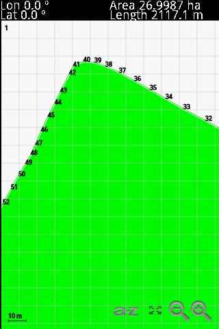
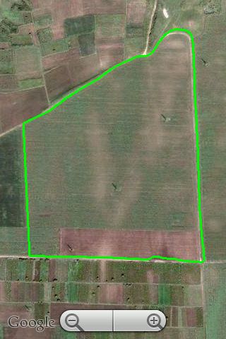
GPS Area Calculation - This program allows you to measure areas of any size, with a precision marked by your own GPS. The larger the area, the better the measure. The perfect tool for field and farm work.
Like it? Share with your friends!
If you got an error while installing Themes, Software or Games, please, read FAQ.
PowerNavigation UIQ PowerNavigation UIQ will let you use your GPS receiver for all kinds of navigation tasks as effectively as possible. You can use custom maps with the help of PowerNavigation.
It will also let you watch direction, movement speed, level of GPS signal and satellites' monitoring, record passed way, create waypoints, tracks and different sound events.
· 15 days trail
GeoLocateDE GeoLocateDE comes with an onboard population center map of 75000 suburbs, towns and cities of Germany. GeoLocateDE allows you to accurately track any vehicle or person carrying a Symbian S60 phone with GeoLocateDE running and connected to a Blue Tooth GPS receiver. You can set tracked contacts with password and then remotely monitor the location of users / vehicles
FON Access Points for Australia FON Access Points for Australia - FON offers you a new Points of Interest service (POIs). This allows you to download FONspots directly to your navigation device.
What does that mean? You can download a Points of Interest file directly to your navigation device
FON Access Points for Guadaloupe FON Access Points for Guadaloupe - FON offers you a new Points of Interest service (POIs). This allows you to download FONspots directly to your navigation device.
What does that mean? You can download a Points of Interest file directly to your navigation device
FON Access Points for Aruba FON Access Points for Aruba - FON offers you a new Points of Interest service (POIs). This allows you to download FONspots directly to your navigation device.
What does that mean? You can download a Points of Interest file directly to your navigation device
Psiloc Where I am Psiloc Where I am is a powerful tool to perform various actions on the Series 60 phones, based on its geographical location.
Locating of the device is based on the GSM network cells. Thanks to the application the GSM network cells ID are not visible for the end user
FON Access Points for Jordan FON Access Points for Jordan - FON offers you a new Points of Interest service (POIs). This allows you to download FONspots directly to your navigation device.
What does that mean? You can download a Points of Interest file directly to your navigation device
FON Access Points for Finland FON Access Points for Finland - FON offers you a new Points of Interest service (POIs). This allows you to download FONspots directly to your navigation device.
What does that mean? You can download a Points of Interest file directly to your navigation device
FON Access Points for Afghanistan FON Access Points for Afghanistan - FON offers you a new Points of Interest service (POIs). This allows you to download FONspots directly to your navigation device.
What does that mean? You can download a Points of Interest file directly to your navigation device
FON Access Points for Czech Republic FON Access Points for Czech Republic - FON offers you a new Points of Interest service (POIs). This allows you to download FONspots directly to your navigation device.
What does that mean? You can download a Points of Interest file directly to your navigation device
Comments on GPS Area Calculation:
Comments not found
If you noted an error or download link is broken, please, report it via this page or use comments.
Please, select device to check if GPS Area Calculation supports it