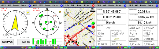
GPS-Navigator is a GPS-based navigation- and positioning- software for the Sony-Ericsson P800/P900/P910. With the program You can navigate to geographical positions. It also shows You informations about the actual position, speed, distances and the satellite-positions. In the actual version it is also possible to navigate along routes.
Program-features:
Navigation to waypoints
Navigation on routes
Compass- and Map-navigation
Download of maps from the internet
Turning of online maps
Map with over 800 worldwide cities
Display of the actual position, time and GPS quality
Statistic of satellites
Statistic of navigation
Statistic of GPS-Data
Plot of GPS-track
Import of maps in bitmap-format (BMP/JPG/GIF)
Import / Export of waypoints, routes and GPS-Tracks in GPX-format
Sound-Output
User defined cities
Coords-format: WGS84 / UTM / Swiss Grid
Danger-waypoints
GoTo - function
New in version 3.02:
- Turning of online maps in 90° steps
- Moving of online maps
Like it? Share with your friends!
If you got an error while installing Themes, Software or Games, please, read FAQ.
Supported operating systems:
UIQ 2.0
Similar Software:
Foreca weather Foreca weather- provides current conditions, 10 day weather forecasts and various weather animations for any location world-wide.
You can choose from over 140.000 hand picked locations or you can retrieve forecasts for your current location using your phone's GPS. You can also use the Landmarks in your phone or you can enter a new location by coordinates
FON Access Points for Martinique FON Access Points for Martinique - FON offers you a new Points of Interest service (POIs). This allows you to download FONspots directly to your navigation device.
What does that mean? You can download a Points of Interest file directly to your navigation device
FON Access Points for Antarctica FON Access Points for Antarctica - FON offers you a new Points of Interest service (POIs). This allows you to download FONspots directly to your navigation device.
What does that mean? You can download a Points of Interest file directly to your navigation device
FON Access Points for Czech Republic FON Access Points for Czech Republic - FON offers you a new Points of Interest service (POIs). This allows you to download FONspots directly to your navigation device.
What does that mean? You can download a Points of Interest file directly to your navigation device
FON Access Points for Madagascar FON Access Points for Madagascar - FON offers you a new Points of Interest service (POIs). This allows you to download FONspots directly to your navigation device.
What does that mean? You can download a Points of Interest file directly to your navigation device
Buddycloud Buddycloud- takes your mobile's address book, mashes it up with our location fingerprint technology and then feeds the results back to your buddies. Buddycloud pushes (and pulls) your location, mood and intended next location to everyone else in your address book
FON Access Points for Algeria FON Access Points for Algeria - FON offers you a new Points of Interest service (POIs). This allows you to download FONspots directly to your navigation device.
What does that mean? You can download a Points of Interest file directly to your navigation device
FON Access Points for Venezuela FON Access Points for Venezuela - FON offers you a new Points of Interest service (POIs). This allows you to download FONspots directly to your navigation device.
What does that mean? You can download a Points of Interest file directly to your navigation device
Nokia Location Tagger With Nokia Location Tagger, you can automatically tag your location data to your pictures. As you take a picture, your GPS coordinates are saved to the EXIF header of the JPEG file. You can use this data later, for example, to locate your pictures on a map.
In the near future, we hope to make location tagging a seamlessly integrated part of your Nokia experience
FON Access Points for United Arab Emirates FON Access Points for United Arab Emirates - FON offers you a new Points of Interest service (POIs). This allows you to download FONspots directly to your navigation device.
What does that mean? You can download a Points of Interest file directly to your navigation device
Other Software by developer «Wohlfahrt EDV»:
Watchdog Watchdog - The "Watchdog" guards Your confidential data in a password-secured database. For data-encryption we use the secure and established Blowfish-Algorithm. The database is encrypted by a user defined access password and is therefor protected against unauthorized access. You can also create a supervisor-password for the database
Star-Roulette Test Your strategy or just have fun!
Main-Features:
Watchdog The watch for Your confidential data and passwords
GPS Navigator GPS Navigator - The GPS-Navigator is a GPS based navigation and positioning software for the Sony-Ericsson P800/P900/910 mobile phone.
For navigation You need a Bluetooth GPS-receiver, that sends the data in the NMEA format (e.g. EMTAC CRUX II/ BTGPS™ Receiver or Falcom Navi-1 Bluetooth GPS Receiver).
With the program you can navigate to geographical positions