CacheTrack- is a Java application for S60 mobile phones that reads files in the Geocaching.com-GPX-format and helps to find geocaches.
CacheTrack is a free application. You just have to visit a web page containing the latest about CacheTrack on your phone to unlock the application for 24 hours.
· Open GPX files which are compatible with Geocaching.com
· record of your tour
· export the recorded tour as a KML file to be viewed with Google Earth
· export waypoints as "Landmarks" e.g. to view them on Nokia Maps or use the "Navigate to" function of your phone
· create new waypoints
· waypoint projection
· view images referenced by the cache description
· view cache logs
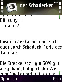
· view cache description
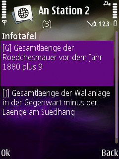
· view cache hints
· can use internal or external GPS receivers
· automate the creation of waypoints based on instructions found in the cache description by the use of a so called "Solver"
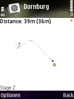
· view an Google Maps image showing the current waypoints
What's New in This Release:
· Can now read new and old Geocaching.com GPX files
Like it? Share with your friends!
If you got an error while installing Themes, Software or Games, please, read FAQ.
FON Access Points for Kuwait FON Access Points for Kuwait - FON offers you a new Points of Interest service (POIs). This allows you to download FONspots directly to your navigation device.
What does that mean? You can download a Points of Interest file directly to your navigation device
CellPos CellPos records the position of GSM/WCDMA network cells automatically.
STARTUP
(0. Start the GPS device)
1. Start the application, select the GPS device (only at the first run)
2. the program works automatically, records each cell you are passing by
3
Locator Locator-
This demo sends the location of the mobile phone to our server (gsm cell identifier or gps information - latitude and longitude). It connects automatically to our server using a predefined GPRS connection, at predefined time periods.
A Bluetooth-capable GPS device is required if you want to send gps information (e.g
FON Access Points for Algeria FON Access Points for Algeria - FON offers you a new Points of Interest service (POIs). This allows you to download FONspots directly to your navigation device.
What does that mean? You can download a Points of Interest file directly to your navigation device
PhoneMap Paris PhoneMap Paris- Full map solution for symbian series 60
View map:Display map,select objects,zoom,pan,...
Search: Search street,location,..by name
Shortest path: Show shortest path and total distance.
GPS: Connect to GPS device by bluetooth,go to location on map
Navitel Navigator for Symbian Navitel Navigator for Symbian - Navitel Navigator is a GPS travel assistant for Symbian. The app turns your phone into a personal navigation system.
Navitel Navigator comes with detailed maps and other useful features, including traffic jams, speedcams, 3D roads and intersections, instant routing and a comprehensive database with points of interest
NMEA Info NMEA Info-A graphical Python program that talks to your GPS, and does useful things with the information. It is able to talk to a Bluetooth GPS (parsing the nmea data strea), or on S60 v3 phones with the LocationRequestor module, an internal GPS
RaceChrono (S60) RaceChrono (S60) is a GPS based lap timing software for Nokia Series 60 smart phones. It can be used to measure lap times on almost any vehicle and track. It can be used to measure laptimes for example for motorbikes, bicycles, cars, water jets and quadbikes.
The main feature is of course the Live Timer, which shows your lap- and sector-times in real-time
NavFun Pro NavFun Pro is the ideal navigation/maps tool that gives you all the goodies of a full featured GPS receiver and Google Maps, Earth, Terrain. Ideal for hiking, geocaching, skiing, mountain biking, and city tours
AFTrack (S60 3rd Edition) AFTrack (S60 3rd Edition) - AFTrack is the display for your GPS mouse and activates the world of hiking, biking, sailing, geocaching or more for your phone. The program handles tracking with smart and fixed logging features.
It sends reports via GPRS or SMS. It receives SMS position messages and show it as a waypoint. It exports and imports waypoints and routes
Other Software by developer «Bjoern Quentin»:
MMS Effects Type in your message and convert it into an animated multimedia message. Choose from seven effects - no more boring text messages
CacheTrack CacheTrack is a Java application for S60 mobile phones that reads files in the Geocaching.com-GPX-format and helps to find geocaches.
CacheTrack is a free application. You just have to visit a web page containing the latest about CacheTrack on your phone to unlock the application for 24 hours.
· Open GPX files which are compatible with Geocaching
MTKTuner A little utility for your J2ME phone to turn WAAS/EGNOS on/off on your MTK powered bluetooth GPS receiver (e.g. the Holux M-1000)
WPAverager WPAverager - WPAverager helps you to create more exact landmarks / waypoints with your mobile device.
You just set how many coordinates it should record and how many of the best ones should be used to average the final location. Then you can save it to the landmarks store. That's it.
You should experiment with the values to get the best results


")

")


