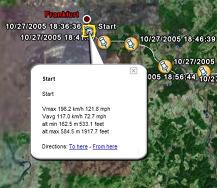
GETrack for UIQ3 - Now you can record tracking data from your bluetooth GPS receiver and send the track via bluetooth to your PC for direct use with "Google Earth". For business, holidays and fun.
There's no need for any conversion software on the PC side. The tracking data is ready to be used with "Google Earth". These files can then be sent by email to your friends or put them on your website.
On the PC side you only need a bluetooth dongle and the ability to receive files from your phone.
You can choose a logging interval from 1,3,5,10,20,30,60 and 300 seconds which covers driving speeds by car and bike and is also suitable for hiking tours.
You can choose to send a file in plain Google Earth format, extended Google Earth format including automatic waypoints including altitude, driving speed and time/date , GPX, IGC and CSV (Microsoft Excel or OpenOffice) format.
Compatible with UIQ3 devices.
You need "Goole Earth" Version 3.0 or better, a NMEA compatible bluetooth GPS receiver and you must be able to receive files via bluetooth from your phone.
Like it? Share with your friends!
If you got an error while installing Themes, Software or Games, please, read FAQ.
Supported operating systems:
UIQ 3.0, UIQ 3.1
Similar Software:
Redpin The aim of the Redpin project is to create an open source system that allows indoor positioning up to room-level description using mobile phones
FON Access Points for South Korea FON Access Points for South Korea - FON offers you a new Points of Interest service (POIs). This allows you to download FONspots directly to your navigation device.
What does that mean? You can download a Points of Interest file directly to your navigation device
nanonavi + Virtual Care 1 Month nanonavi + Virtual Care 1 Month- This application offers users a breakthrough personal tracking and monitoring functionality to care remotely for family members, friends and possessions anywhere in the world
FON Access Points for Guadaloupe FON Access Points for Guadaloupe - FON offers you a new Points of Interest service (POIs). This allows you to download FONspots directly to your navigation device.
What does that mean? You can download a Points of Interest file directly to your navigation device
PyPOIAlert PyPOIAlert is a POI (Points of Interest) alerter.
Installation notes:
Install all sis-files on c:
* Install Python for S60
* Sign the following files:
-> locationrequestor_3rd.sis
-> envy_3rd_1_0_4_unsigned.sis
-> PyPOIAlert_v0_5_2_unsigned.sis
* Install the above sis-files on C:
Using PyPOIAlert:
- Start PyPOIAlert from your programs folder
Trapster Trapster – When you see a trap, report it by pressing a button on your phone, or calling a toll free number. Other user's phones will alert them as they approach the trap. Trapster learns the credibility of traps based on how many users agree. It also learns the credibility of each user, over time
Easy Locator Find the location of a mobile phone and see it on the map! Locate people via their phones or simply find your device if lost or stolen. Try for free!
Psiloc Where I Am Psiloc Where I Am is a powerful tool to perform various actions on the Sony Ericsson P800, P900, based on its geographical location.
Locating of the device is based on the GSM network cells. Thanks to the application the GSM network cells ID are not visible for the end user
NMEA Info NMEA Info-A graphical Python program that talks to your GPS, and does useful things with the information. It is able to talk to a Bluetooth GPS (parsing the nmea data strea), or on S60 v3 phones with the LocationRequestor module, an internal GPS
Other Software by developer «Quentin»:
Series 60 Screensaver Source Code Series 60 Screensaver Source Code - Sourcecode of a Series 60 2nd Edition screensaver plugin. The demoversion only contains the binary SIS installer. Start writing your own screensaver plugins using C++ based on this source code right now. The sourcecode is compatible with the Series 60 SDK 2.0 for Symbian OS
POIXpress POIXpress - Modern location aware applications running on S60 3rd Edition devices like smart2go(TM) aka Nokia Maps use a shared database of POIs (called landmarks).
With POIXpress you can import POI databases in ASC and OV2 format and export landmarks in ASC,GPX and KML format
GETrack GETrack - Now you can record tracking data from your bluetooth GPS receiver and send the track via bluetooth to your PC for direct use with "Google Earth". For business, holidays and fun.
There's no need for any conversion software on the PC side. The tracking data is ready to be used with "Google Earth"
S60 Screensaver Maker Pro S60 Screensaver Maker Pro - Using this PC application you can create custom screensavers for Nokia S60 2nd Edition devices from a GIF file.
The created screensaver will be automatically packaged into a SIS installer and is ready to be installed on a S60 2nd Edition device. The screensaver turns the backlight on (not on 3230,6260,6600,6620,6670,7610) when it starts
TweakME TweakME is used for modifying the security settings of Java midlets on the Nokia 6600 phone.
With TweakME you can set all permissions for a midlet regardless if it's signed or not
GETrack GETrack - Now you can record tracking data from your bluetooth GPS receiver and send the track via bluetooth to your PC for direct use with "Google Earth". For business, holidays and fun.
There's no need for any conversion software on the PC side. The tracking data is ready to be used with "Google Earth"