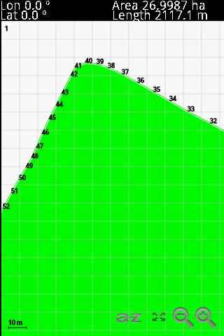
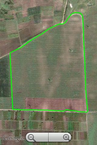
GPS Area Calculation - This program allows you to measure areas of any size, with a precision marked by your own GPS. The larger the area, the better the measure. The perfect tool for field and farm work.
Like it? Share with your friends!
If you got an error while installing Themes, Software or Games, please, read FAQ.
SMap SMap allows you to record and manage your running, hiking, cycling, MTB or sailing routes and easily upload them onto the Sanoodi website live via GPRS or later when you connect your mobile to your desktop computer.
· Two screens: a Pace Screen and a route Summary Screen
MyLocation Script for mShell MyLocation Script for mShell-Use your mobile phone as your location tracker. The software sends an automated reply to anyone who intends to know your location. If your current location cannot be determined, it sends your last recorded known location and its time
Magic Wand Magic Wand is an application for tourists, which makes exploring a foreign city easier. It enables the user to identify a sight without a tourist guide book, but by using the mobile phone. The tourist just has to hold the mobile phone in the direction of the sight to identify it. With a keystroke, the name of the sight is shown on the display
FON Access Points for Afghanistan FON Access Points for Afghanistan - FON offers you a new Points of Interest service (POIs). This allows you to download FONspots directly to your navigation device.
What does that mean? You can download a Points of Interest file directly to your navigation device
GyPSii (S60 3rd Edition) GyPSii (S60 3rd Edition)-is the consumer application for mobile, web & Internet connected devices.
GyPSii allows users to share their real life experiences in the virtual world using mobile devices and the web
Phone2GEarth S80 Phone2GEarth S80 converts GPS data directly to Google Earth® KML files.
Phone2Gearth is an easy Nokia Series 80 GPS aplication that allows to log tracks which are directly saved as Google Earth KML files.
New and usefull features like (Version 1.08):
- English, Spanish, German and French languages.
- Placemarks supported with timestamps in the track
Driving Log Driving Log- Keep track of distances traveled for business by using your mobile device. Driving Log makes entering trips simple and automatically updates your web account the next time you sync from your phone or PDA. The secure online environment allows you to view and maintain trip data for complete and accurate reporting
Endomondo Sports Tracker Endomondo Sports Tracker is your personal trainer for running, cycling, walking and other sports
FON Access Points for Mexico FON Access Points for Mexico - FON offers you a new Points of Interest service (POIs). This allows you to download FONspots directly to your navigation device.
What does that mean? You can download a Points of Interest file directly to your navigation device
Comments on GPS Area Calculation:
Comments not found
If you noted an error or download link is broken, please, report it via this page or use comments.
Please, select device to check if GPS Area Calculation supports it


")


