Rough Guides Map New York City... These guides are a series of fantastic interactive maps.
Produced in conjunction with the premier travel publisher Rough Guides.
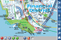
Discover and explore New York City using full colour interactive linked maps, in this simple to use PDA version of The Rough Guides New York City.
Find all the top tourist spots and key attractions with ease, information on the city and its sights can be quickly displayed with links to photographs and map locations. All in a superb easy to use interface.
If you''re travelling to New York City, be sure you don''t leave home without this guide on your PDA.
The Rough Guide city maps includes:
Fully scrollable and interactive maps of the city.
Tap any location to display information and available links.
Intuitive navigation bar meaning you are never more than one click away from the information you require.
Map links allow you to directly link to other maps, photographs, or detailed views.
Categorised Find feature allowing you to quickly find any street, place of interest or station.
Categorised Information feature providing a wealth of information on the city, places of interest, etc.
1-Click Home feature, keeping the Home map always at hand.
Zoom function on all maps.
Special Offer Only $20.00
Hi Res & landscape displays supported.
Like it? Share with your friends!
If you got an error while installing Themes, Software or Games, please, read FAQ.
Supported operating systems:
Pocket PC 2002, Windows Mobile 2003, Windows Mobile 5.0, Windows Mobile 6 Classic, Windows Mobile 6 Professional, Windows Mobile 6.1 Classic, Windows Mobile 6.1 Professional, Windows Mobile 6.5 Professional
Similar Software:
TrackyPro (online GoogleMaps with GPS) TrackyPro - If you have taken your auto navigation system into the woods you probably realized that it becomes more of a paper weight than a navigation device. Without roads most cannot function. That is why you may need off-road navigation software
TwitterGPSer TwitterGPSer uses the GPS on your PocketPC to find your current latitude/longitude/speed and allows you to update Twitter.com. Tap the button to get the GPS lock and when the program gets the lock it will create a Tweet with a Google.com map link. This service is provided by Twitter
CarsMapper CarsMapper - This program allows you to set your home address/city/country. Then enter a local address and tap the button to view a route from or to your home location via Microsoft Live.com Service.
This program requires that you have both the 'BeanDLL.dll' file ** and ** the runtime files for Visual Basic on your PocketPC computer
TerraTrack Recorder 7 Route guidance in 3D view, makes navigation processes very simple and intuitive
iPlotter A comprehensive maritime passage planning and chart plotter navigation aid for Windows Mobile
MapTexterer MapTexterer - MapTexterer allows you to create text based GPS maps. When you get a GPS lock then you can create a new map and enter text for the area. When you save the text the map is downloaded and the text and GPS is appended to the end of the map with current GPS.
This program requires that you have both the 'BeanDLL
Speereo Voice Translator: English-Finnish (WM) Speereo Voice Translator (SVT) is an ideal companion for traveling on business or leisure and also is an excellent aid for business communication. Running on Windows Mobile and Symbian based mobile devices it contains of over 4000 phrases in each of 16+ languages and many other useful features
Travel Europe - A complete Guide, Road maps, and Phrasebook By Rick Steve Travel Europe - Rick Steves doesn't just list where to travel in Europe, he gives travelers inside information on where to stay, what to visit, and how to get there -- economically and hassle-free. With Rick Steves as their guide, travelers can delve into European culture, make friends with the locals, and experience everything Europe has to offer
zhiing - LBS for Everyone zhiing is a location messaging tool that allows you to share your location, or other locations of interest, with your friends, family or co-workers. Even update your location on your favorite social network! Forget about map printouts or scribbling down directions....just zhiing the location! Simply enter the mobile number or email you want to zhiing, and press send
Map of Madrid / Spain for City Advisor Madrid / Spain map for City Advisor.
1. Download the map (zip file)
2. Extract the files in /CityAdvisor/maps
3. Open CityAdvisor -> Maps icon -> Menu -> Refresh
4
Other Software by developer «Visual IT»:
London Underground for iPad by Zuti London Underground 10 is a superb map and route planner for the London Underground, Overground and Docklands Light Railway (DLR) services. So you can make a quick exit when you leave the train we have now added exit information for all stations on the London Underground
Rough Guides Map Barcelona Rough Guides Map Barcelona... These guides are a series of fantastic interactive maps.
Produced in conjunction with the premier travel publisher Rough Guides.
Discover and explore Barcelona using full colour interactive linked maps, in this simple to use PDA version of The Rough Guides Barcelona
Tube Hamburg (Seris 60) Tube Hamburg (Seris 60) - Our highly acclaimed Tube application that guides you around the metro system of Hamburg is now available for your Series 60 Symbian powered phone. An essential addition to your phone for locals and tourists alike.
· A detailed clear colour map of the Hamburg metro (S-Bahn / U-Bahn) system fully scrollable
Tube Chicago Pro (Palm OS) Tube Chicago Pro (Palm OS) - This award winning and highly acclaimed Palm application that guides you around the subway system of Chicago now comes in a pro version with these extra features :
A superb full colour street level map of the downtown Chicago area with a find feature that enables you to quickly find any street, place of interest or station on the map
Berlin Metro by Zuti Berlin Metro by Zuti - The new Berlin Metro map makes it easy to travel in and around the city using the Metro (U-Bahn) Suburban Rail (S-Bahn) and Tram (MetroTram and Straßenbahn) systems
Tube Tokyo (Series 60) Tube Tokyo (Series 60) - Our highly acclaimed Tube application that guides you around the complex subway system of Tokyo City is now available for your Series 60 Symbian powered phone. An essential addition to your phone for locals and tourists alike.
· A detailed clear colour map of the transport system fully scrollable.
· Quick find station utility
Tube 2 Chicago (UIQ) Tube 2 Chicago (UIQ) - This map package for Tube 2 consists of a fully scrollable detailed map of the Chicago metro & commuter rail system.
It includes the rapid transport system of subway and elevated lines, in addition to the many commuter rail lines. The map also indicates how the Amtrak intercity routes intersect with the cities transport network
Tube 2 Melbourne (Palm OS) Tube 2 Melbourne (Palm OS) - This map package for Tube 2 consists of a fully scrollable detailed map of the Melbourne metro & rail system.
Plan journeys on this system, list details of the quickest routes and see a superb animated display of your journey tracking around the system map
Tube Sydney Pro (Palm OS) Tube Sydney Pro (Palm OS) - This award winning and highly acclaimed Palm application that guides you around the complex rail system of Sydney now comes in a pro version with these extra features :
A superb full colour street level map of the central Sydney area with a find feature that enables you to quickly find any street, place of interest or station on the map
Tube 2 Berlin (UIQ) Tube 2 Berlin (UIQ) - This map package for Tube 2 consists of a fully scrollable detailed map of the Berlin Metro (U-Bahn/S-Bahn).
Plan journeys on this system, list details of the quickest routes and see a superb animated display of your journey tracking around the system map.
Berlin is the capital and largest city in Germany

")


 Hi Res & landscape displays supported.
 ")


")


")
")

")
")
")
")
")