TouringNavigation - It is a navigation application program for the motorcycle and the bicycle, etc.
It is a navigation application for the motorcycle and the bicycle, etc.
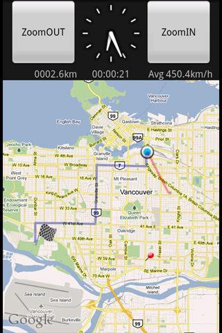
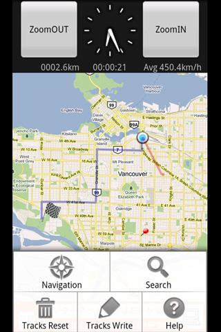
This application displays the route guide, tracks, the mileage that has been passed, the running time , and the mean time velocity.
Tracks that have been passed also provide the function to output to the SD card by the GPX format.(GPS Logger)
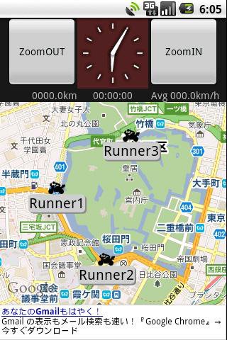
This application provides the location sharing service "Where everyone?".
"Where everyone?" is ability to understand each other, where you are now someone else on the map.
*** Let's try "Where everyone?" ***
Please push Menu button,
and tap the 'Where everyone?' button.
The Input dialog is displayed.
Input keyword 'test' and Tap 'OK' button.
The map is displayed, Please see aroud Tokyo Japan.
you can see 4 test runnners.
Like it? Share with your friends!
Supported operating systems:
Google Android 1.5, Google Android 1.6, Google Android 2.0, Google Android 2.1, Google Android 2.2, Google Android 2.3, Google Android 3.0, Google Android 3.1
Similar Software:
MapMyRIDE GPS Cycling Riding MapMyRIDE GPS Cycling Riding - tracks the route, distance, pace, and more in real-time using GPS.
NEW: iMapMyRIDE+ for Android
iMapMyRIDE+ brings you its mobile app for Android-based devices! Now owners of Android 2
Mobile Spy Track EVERY move your child or employee makes using our POWERFUL cell phone monitoring technology to expose the TRUTH!Mobile Spy is a hybrid software/service which allows you to monitor our child or employee's smartphone in real time
Navitel Navigator for Android Navitel Navigator for Android - Navitel Navigator is a GPS travel assistant for Android. The app turns your phone into a personal navigation system.
Navitel Navigator comes with detailed maps and other useful features, including traffic jams, speedcams, 3D roads and intersections, instant routing and a comprehensive database with points of interest
iMapMyFITNESS+ Fitness App iMapMyFITNESS+ Fitness App - tracks the route, distance, pace, and more in real-time using GPS.
Free new version!
iMapMyFITNESS brings you its mobile app for Android-based devices! Now owners of Android 2.1 or higher devices can track the route, time, distance, speed, pace and calories in real-time for their fitness activities using their GPS enabled mobile device
Track My Mobile Track My Mobile - Your mobile phone can be Tracked by this applicatio after it get lost
AndTripLog AndTripLog allows you to record your trip onto your device. The application displays the current GPS position, time and speed. You can export the trip by email and store it onto your sdcard in GPX format
GeoBeagle GeoBeagle is a free, open source application for the Android platform to aid users in finding geocaches and letterboxes. It enables the user to do paperless geocaching.
Geocaches and letterboxes are objects that have been hidden in the real world; the game of geocaching/letterboxing is finding these objects around you
Locate My Family Locate My Family - Why do you need Locate My Family application?
1. Locate My Family tracks, monitors and manages an individual or group of people for operational and safety security reasons.
How to start?
1. Install the application on your Android phone.
2. Create your account by providing your email id, phone number of the device, name, country and submit it.
3
amAze (Samsung) AmAze is a first of its kind free navigation and local search service. It is free to download and use and it contains wide coverage of maps including aerial photo in Europe, North America, Australia and parts of Asia and Africa
TripComputer TripComputer is a personal off-road GPS navigation utility software for Android phones, that has been created for active people, who love travel by hike or bike.
The application does not use Internet connection or Google Maps for navigation or track recording, but you can share your data to others, or store your data on server
Other Software by developer «kazuhito kawabe»:
not found
Comments on TouringNavigation:
Comments not found
If you noted an error or download link is broken, please, report it via this page or use comments.
TouringNavigation is compatible with your device T-Mobile Pulse (Huawei U8220)

")


")
