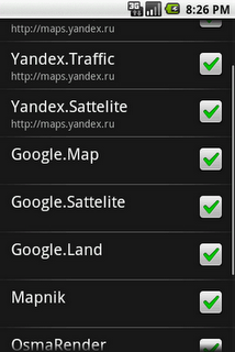
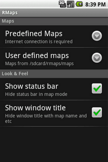
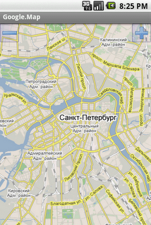
RMaps is a navigation tool. You can use RMaps as an online map viewer for some popular maps. And as an offline map viewer for your own maps created on the PC.
· Auto rotate map in driving direction.
· Auto rotate map in the northern direction.
· Compass on the map.
· Auto-follow function.
· Online search.
· Full screen mode.
· GPS and wireless network mode.
· Indicator accuracy like on Google map.
What's New in This Release:
· Dashboard. Long press on dashboard to add or change value
· I am here: Long press on the screen to point your location without GPS
· Target point (use the map context menu)
· Ability to use volume controls to zoom map
· Ability to export import POI category with the POI
· Ability to use custom cursors
· Ability to download online map directly to online cache
· Updated URLs
· Improving downloader service, Track writer service
· Fixed some GPX importing bugs
What's New in 0.9.3.1:
· Fixed add POI, search bugs
What's New in 0.9.3:
· Been improved measure tool
· Ability to use the app on a devices without GPS
· Long press on the map now shows the coordinates etc. Clicking on a black bubble shows the context menu
· Coordinates formatting preference
· Ability set Zoom controls at the right
· Ability download to offline a layers
· Build-in ability to download Geology and Geophysics offline maps from www.dpi.nsw.gov.au/minerals
· Fix scale bar bug
· Fix some POI bug
What's New in 0.9.2:
· Opened Google Community RMaps on Google+ (users support, beta testing)
· Measuring distances (Menu - Tools - Measure)
· Distance circles around current location
· Joining multiple tracks into one
· New Relief map
· Reload/update tiles tool on the screen online map (Menu - Tools - Reload screen tiles)
· OSGB 36 for offline Ordnance Survey Map
· Compass fix
· Loading circles after download fix
· White POI on SONY fix
· Google.Land, Google.Satellite fix
What's New in 0.9.1:
· BING maps (Road, Aerial, Hybrid)
· USA Topo maps, ArcGIS USA maps, USGS Topo maps
· Improve usability of POI category list
· Improve usability of maps list in settings
· Line between current GPS location and center of screen
· Share POI function
· Altitude field in POI activity
· Map offset function (useful for Chinese users)
· Stretch factor of map, ability to enlarge picture of any map
· Offline maps bug fix
What's New in 0.9.0.1:
· Debug bug fix
· Correct translation
What's New in 0.8.9:
· Crosshair on center of the map
· Added new map maps.refuges.info
· Bug fix
What's New in 0.8.7.3:
· New preference Directory
· Now RMaps stores tiles of online maps on sdcard in sqlite format
What's New in 0.8.6.1:
· Bug fix
What's New in 0.8.6:
· New maps: VFR (avcharts.com), MyTopo, OSM MTB Mapa Česká republika
· Error report
· Bug fix: Multitouch, Scale bar, more
What's New in 0.8.5:
· Scale bar, Units property
What's New in 0.8.4.1:
· Multitouch zooming
· Zoom buttons settings: top, bottom, hide
What's New in 0.8.3.1:
· Fix export track to GPX, KML file
Like it? Share with your friends!
Supported operating systems:
Google Android 1.0, Google Android 1.5, Google Android 1.6, Google Android 10.x, Google Android 2.0, Google Android 2.1, Google Android 2.2, Google Android 2.3, Google Android 3.0, Google Android 3.1, Google Android 3.2, Google Android 4.0, Google Android 4.1, Google Android 4.2, Google Android 4.3, Google Android 4.4, Google Android 5.x, Google Android 6.x, Google Android 7.x, Google Android 8.x, Google Android 9.x
Similar Software:
iMapMyRUN Run GPS Running Jog iMapMyRUN Run GPS Running Jog - iMapMyRUN+ tracks the route, distance, pace, and more in real-time using GPS.
Free new version!
iMapMyRUN+ brings you its mobile app for Android-based devices! Now owners of Android 2
eGPS Lite eGPS Lite has full GPS capabilities, showing latitude and longitude, altitude, speed, and heading. This makes it useful for all kinds of activities where you would usually want a GPS device - hiking, cycling, geocaching and letterboxing, running, location-based social networking activities, and more
AntipodalPoint AntipodalPoint retrieves you position from the network provider or GPS and calculates and shows you antipodal point - the place exact opposite of you on Earth.
AntipodalPoint Pro enables you to browse the entire world and find antipodal points
Naver Maps Naver Maps - Smarter than ever! Experience Naver Map for Android. You can find the shortest way to get to your destination, using public transportation even it is far away. You can also search the information on the area around you easily and check whether you are heading to your destination correctly with GPS and compass
InstaMapper (Android) InstaMapper is a free service that allows you to track a person or vehicle online in real time using a GPS-enabled mobile phone.
To use InstaMapper, you create a free account. Registration takes only a minute or two. All it is asked for is a username, password, and a valid email address.
Next, you install a small application on your GPS-enabled phone
Send My Position Send My Position is an application which shows your current location using GPS and allows you to send the coordinates using SMS as Google Maps links.
· Shows your current location using GPS
· Allows you to send your location coordinates to anyone using SMS
· Google Maps link send using SMS (Android, iPhone..
GPS Status & Toolbox GPS Status & Toolbox - Be a GEEK: Get the most out of your phone. Raw GPS data at your fingertips.
Display your GPS and sensor data: position and signal strength of satellites, accuracy, speed, acceleration, bearing.
Tools included: compass with magnetic and true north, leveling tool, mark or share your location and navigate back later
Satsports Log Satsports Log is your general sport app. Ideal for running, cycling, mountain biking, hiking and walking. It also has some fun visual features such as maps and graphs of your elevation, speed and pace. Real time Statistics: Satsports-log has all the stats you could wish
SportsTracker (by STL) SportsTracker (by STL) - Share, compare, train and compete in your sport on
http://sportstracklive.com
Live sports tracking from your android phone
http://sportstracklive.com
Beat your personal bests!
Superior GPS sports tracking app. Running, cycling, mountain biking, skiing, snowboarding, sailing, biking, flying, gliding
VGPS (Vietnamese GPS) for Android VGPS (Vietnamese GPS) for Android was designed to use city street map on your ordinary mobile phone without the need of having GPS receiver or internet connection. VGPS does not require internal or external GPS receiver. However, if you have internal GPS receiver or external bluetooth GPS receiver, VGPS can work with your GPS receiver as well
Other Software by developer «RobertK506»:
not found
Comments on RMaps:
Matt Murphy:
Cool I want to give this a shot.
Date: 23 Jul 10
If you noted an error or download link is broken, please, report it via this page or use comments.
RMaps is compatible with your device T-Mobile Pulse (Huawei U8220)