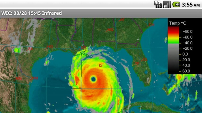
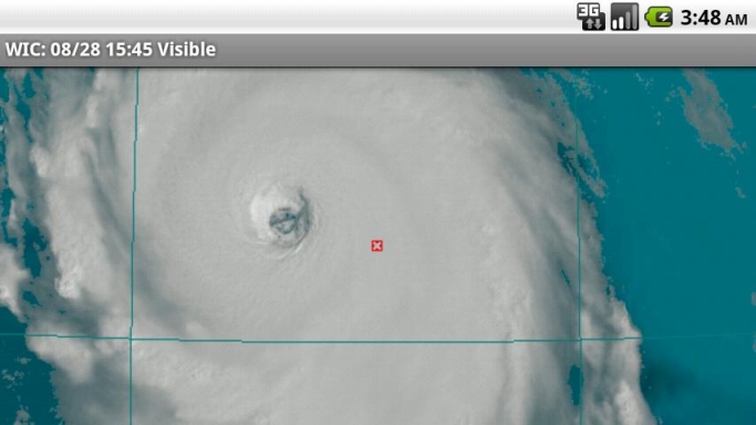
Where's It Cloudy is an Android application that shows real-time satellite data from the American Geostationary Weather Satellites. As a mobile phone application, you may access it to find out where it's cloudy in the vicinity of where you are located, or anywhere in the eastern and central United States and southern Canada. Most other weather apps do not show satellite imagery; they only show radar data. Radar data is effective at showing where there is rain and snow, but it doesn't show where clouds are located. Currently the App will NOT show imagery covering the West Coast.
The satellite data shown in Where's It Cloudy? is ideal for several purposes including:
· showing cloudy regions
· detecting the likelihood of precipitation
· helping track moderate to severe storms and hurricanes
· showing the movement, rotation, and structure of storms
· display of images in a time-lapsed loop.
Traditional weather applications show imagery covering only predefined areas at predefined resolutions. Where's It Cloudy? goes beyond this to allow the user to choose a default viewing point anywhere in North America, and a viewing altitude that determines the area the image will cover. A cloud computing platform renders the data based on your selections. The Cloud for Clouds!!
Once you set your default location and altitude, the image loops are dynamically generated at the maximum possible resolution from a 3D model of the Earth with the real time satellite imagery overlaid on this realistic model. This provides stunning and accurate visuals, especially in the Visible channel of satellite data.
Unlike other programs that may show the satellite imagery in a few shades at a reduced level of detail Where's it cloudy shows satellite imagery in full detail and in as many shades as are possible on your device. We also do not use lossy compression to preserve as much detail as possible.
If you select Tru-Sat Image it will show the raw satellite image as it was imaged from the satellite which in many cases can show much more detail. Give it a try you will be impressed.
What's New in This Release:
· Image Times are now in local time as determined by your devices time zone setting.
Like it? Share with your friends!
Supported operating systems:
Google Android 1.5, Google Android 1.6, Google Android 10.x, Google Android 2.0, Google Android 2.1, Google Android 2.2, Google Android 2.3, Google Android 3.0, Google Android 3.1, Google Android 3.2, Google Android 4.0, Google Android 4.1, Google Android 4.2, Google Android 4.3, Google Android 4.4, Google Android 5.x, Google Android 6.x, Google Android 7.x, Google Android 8.x, Google Android 9.x
Similar Software:
Weather timeline Weather timeline - is a simple weather forecast application which will sum up weather statistics for the next week. Expanded and detailed weather forecast you can always use! Weather information is marked with color depending on the situation, thanks to this you can see the coming weather at once
Weather Weather mobile download is a weather widget and calendar
Weather for Switzerland Weather forecast LIVE detailed and updated several times a day for Switzerland. Find quickly and easily every day the weather forecast LIVE detailed and updated several times a day for Switzerland. - Temperature - Limit of snowfall
Earthquake! Earthquake! - Get a head start on the apocalypse! 24h of quakes mapped.
Get a head start on the apocalypse with Earthquake!
Last 24hrs of earthquakes, with damage and rumble areas shown on an interactive map. Features notifications and vibration to indicate quake magnitude, and a dynamic widget
WeatherBug Elite for Android Get current conditions, extended forecast, temperature and satellite maps, radar animation, severe weather alerts and more from WeatherBug ? the world’'s largest weather network
14FirstAlert Weather TriState 14FirstAlert Weather TriState - Get the power of 14NEWS for Tri-State weather. Download our local weather app, 14 First Alert, right to your Android phone!
The local forecast, radar, and current weather conditions for Indiana, Kentucky and Illinois are all within this app, including Evansville, Henderson, Owensboro, Newburgh, Jasper, Madisonville, Princeton, Mt
Radioactive Cloud Radioactive Cloud - This animation displays a potential dispersion of the radioactive cloud (Caesium 137 Isotope) after the nuclear accident in reactor Fukushima
Hurricane Software Hurricane Software - Hurricane Tracking application to give you the most up to-date and reliable hurricane coordinates data and high resolution maps.
Satellite Images, Warning Information, Storm Tracks and More
Meteoprog: Dressed by weather Meteoprog: Dressed by weather - is an application which reflects the information about weather change all over the world. You can observe weather by hours in your clock. The application reflects temperature, wind, humidity indicators as well as avatars which can help you put on appropriate clothes according to the weather conditions
Flipboard Flipboard - electronic news journal. Set up news categories according to the interests and get notifications on the latest important events in the world. Connect your favorite blogs or feeds of news sites in order to gather all information in one application
Other Software by developer «Aquila Systems»:
not found
Comments on Where's It Cloudy:
Comments not found
If you noted an error or download link is broken, please, report it via this page or use comments.
Where's It Cloudy is compatible with your device TCL Optus X Start TD-LTE AU (TCL U3A)

")