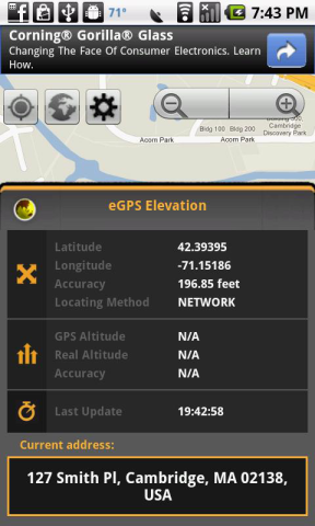
eGPS Elevation has greatly improved altitude and elevation readings. In a typical Android GPS, altitude readings are notoriously inaccurate. eGPS Elevation will even show how deep is the nearest water area.
!!!Works with GPS feature turned off!!!
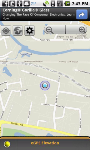
eGPS Elevation will come in handy for any fan of outdoor activities such as hiking, cycling, camping or any location-based social networking activities. It also uses the most advanced map technology to give you precise directions and pinpoint your destination address down to the zip code. Anyone who has ever found themselves on a road trip in an unfamiliar city will be able to appreciate the ability to receive such accurate directions whenever they want to find a restaurant, gas station or hotel.
eGPS Elevation app is sure to please fans of our eGPS Lite. Like the eGPS Lite, this app has all the GPS capabilities you could ask for and shows your destination or location down to the latitude and longitude, speed and heading.
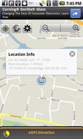
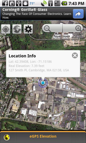
The biggest difference between this app and the eGPS Lite is that this app has greatly improved altitude and elevation readings. In a typical Android GPS, altitude readings are notoriously inaccurate. People don't always think about things such as altitude and elevation when they are deciding on where they want to go when they travel, but it is a bigger factor that many realize. High altitude can have an effect on a person's health if he isn't used to it. The thinner air can result in issues such as shallower breathing, insomnia and decreased appetite. These are by no means severe, but they can be bothersome. Knowing a location's real altitude and real elevation can indeed come in handy, and with this app you can be sure that your GPS altitude and GPS elevation will be far more accurate than what can be found on any other Android GPS app on the market. Just touch any part of the map screen on the app's easy-to-read interface to know the exact altitude and elevation of that location.
Like it? Share with your friends!
Supported operating systems:
Google Android 1.0, Google Android 1.5, Google Android 1.6, Google Android 10.x, Google Android 2.0, Google Android 2.1, Google Android 2.2, Google Android 2.3, Google Android 3.0, Google Android 3.1, Google Android 3.2, Google Android 4.0, Google Android 4.1, Google Android 4.2, Google Android 4.3, Google Android 4.4, Google Android 5.x, Google Android 6.x, Google Android 7.x, Google Android 8.x, Google Android 9.x
Similar Software:
CompassPro CompassPro - Best Compass application for Android! Two fantastic compass styles to choose from.
You can have a compass icon always showing on your phone screen! The size and display area can be easily configured.
Note: You need to Calibrate the Sensor Compass first: Rotating your phone around all axes in a continuous movement
SharpSol Pedometer Free SharpSol Pedometer Free - Adjust settings first.
Air Push ads completely removed in this update.
Facebook posting bug removed
resting values dialog added.
Speach API working 100% accurate now.
No popup ads.
absolutely free with charts support.
Welcome to SharpSol Pedometer
How Tall Pro How Tall Pro - Attention! Only play on soft area or with a nice catcher!
Sound may scare others!
How-To
Thumb on screen and drop your Android phone VERTICALLY. The droid will find out the height, and then analyze who you are
Point Lite Point Lite Want to know where you are relative to specific places important to you? Or where to go?Point shows it to you in one glance!Add your own points of interest. Mark your current spot before taking a stroll to easily find your way back.Or ask Point to give you a sign when you are near an important spot
3D Compass (AR Compass) 3D Compass (AR Compass) - 3D compass with augmented reality view, Auto rotate map, Big heading degrees
This is a compass app with augmented reality view and real time map update, and provides real time location information
Surveyor Surveyor - Measure distances with a single click on your Android phone!
All you need to do is point your phone to the object you want to measure, and select the point where it touches ground from the screen.
What's New in This Release:
· Use gyroscope to improve accuracy and smoothness of Augmented Reality result
Smart Tools Smart Tools is a complete package of 6 app sets. I
Compass Professional Compass Professional - Compass is easy to use; just use it like a real compass. Compass app is more than just showing degrees and north, south, east and west. I have designed Compass with user experience in mind, large numbers and easy to read design. Compass also allows you to set your directions by rotating the bezel for easier and professional navigation
GeoLog GeoLog saves the sensors data (gps, accelerometer, magnetometer data, etc.) of your device to a log file and calculates the coverage of the site. The coverage is a ratio of the track covering area to the area of the site (expressed in percents)
Naver Maps Naver Maps - Smarter than ever! Experience Naver Map for Android. You can find the shortest way to get to your destination, using public transportation even it is far away. You can also search the information on the area around you easily and check whether you are heading to your destination correctly with GPS and compass
Other Software by developer «Exetik Systems, LLC»:
eGPS Lite eGPS Lite has full GPS capabilities, showing latitude and longitude, altitude, speed, and heading. This makes it useful for all kinds of activities where you would usually want a GPS device - hiking, cycling, geocaching and letterboxing, running, location-based social networking activities, and more


")


