Categories: Business & Profession, Travel & Navigation
Upload date: 2 Jan 12
Developer: Garmin
License: Freeware
Downloads: 13705
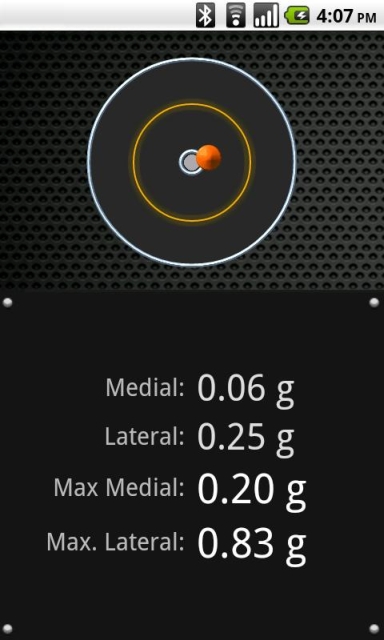
Garmin Mechanic - Get insight into how your car is performing with the free Garmin Mechanic application. Use the Skidpad to measure lateral acceleration, and track your speed and distance using GPS.
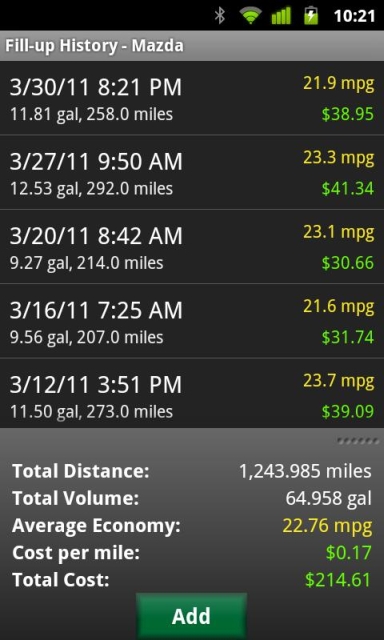
Taking a trip? Garmin Mechanic tracks your trips and calculates total distance, average speed, and estimated mileage to help increase fuel savings. Got more than one vehicle? You can track and collect data on multiple vehicles.
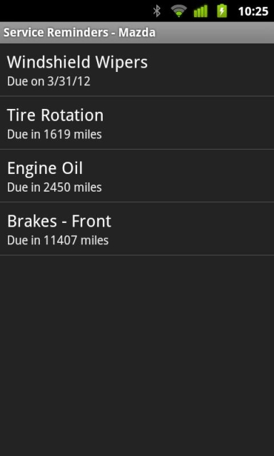
At the pump, enter your fill-up data and track average mileage, total fuel used, fuel cost, cost per mile and more. Set up service schedules for maintenance on all your vehicles, and get notifications when service is due.
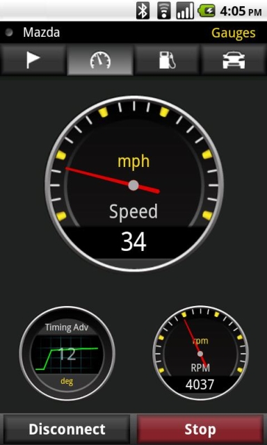
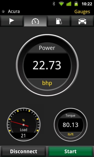
Expand your toolbox by pairing the Garmin Mechanic app with our ecoRoute HD module (sold separately) and gain access to real-time performance data, including live gauges showing RPM, throttle position, intake pressure, manifold vacuum, boost, instant economy, battery voltage, real-time estimated power and torque, and more. Evaluate your driving style with the Eco Score gauge.
Create gauge sets and save them as Dashboards, and instantly recall them for different driving modes (e.g. towing, economy, racing).
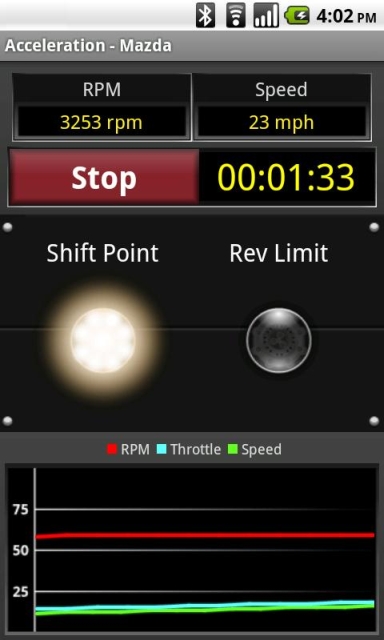
Measure your vehicle's performance with the Acceleration/Dyno feature. Measure 0-30, 0-60 and 1/4-mile times, torque and horsepower.
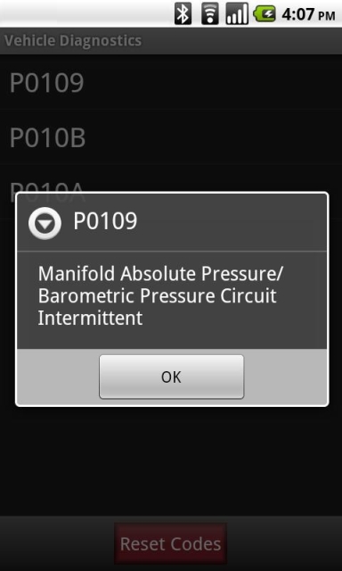
With the ecoRoute HD module, Garmin Mechanic also calculates your instant and average fuel economy, and checks your vehicle’s self-test status for emissions certification. The vehicle diagnostics feature reads and provides descriptions for over 6500 error codes and resets your vehicle’s Check Engine light.
Export all your vehicle information (including fill-ups, service schedule, service history, sensor data, diagnostic data, acceleration runs and more) to view on your computer.
· Tablet support -- works with 7" and 10" tablets (all Android versions)
· Move to SD Card option
· Track average mileage and service history on multiple vehicles Features (when paired with ecoRoute HD module):
· View diagnostic codes and reset your vehicle's Check Engine light
· View and record real-time sensor data
· Calculate real-time and average fuel consumption
· Measure acceleration and calculate 0-30, 0-60, A¼-mile times, torque and horsepower.
· Record OBD sensor data from your vehicle and view it on your computer
What's New in This Release:
· Update to support Android 4.0 (Ice Cream Sandwich) on small devices.
What's New in 1.2:
· New Gauges: Boost, Eco Score, Battery Voltage, Instant Economy
· Dashboard support: Save gauge sets for instant recall
· Trigger acceleration runs with device accelerometer
· Fuel-economy readings available in MPG, km/Liter, and Liter/100km
· Tablet support -- Works on 7" and 10" tablets (all Android versions)
Like it? Share with your friends!
Supported operating systems:
Google Android 10.x, Google Android 2.1, Google Android 2.2, Google Android 2.3, Google Android 3.0, Google Android 3.1, Google Android 3.2, Google Android 4.0, Google Android 4.1, Google Android 4.2, Google Android 4.3, Google Android 4.4, Google Android 5.x, Google Android 6.x, Google Android 7.x, Google Android 8.x, Google Android 9.x
Similar Software:
Compass XL Compass XL - Compass XL is a tool to search bearings (azimuth) using the device built-in magnetic sensors and the device GPS. You can also easy switch from true North and magnetic North. The compass accuracy depends on the performance of your device. If it works perfectly, this means your sensors are perfect, too
Smart compass Smart compass - turn your device into a smart compass which will easily define your direction and location. This compass will be useful while travelling. Send current coordinates of your location via sms or email
Smart Tools Smart Tools is a complete package of 6 app sets. I
Compass (Android) Compass is a navigational instrument for determining direction relative to the Earth's magnetic poles
Analog Compass Analog Compass is an Android application that simulates the physical behavior of a real compass
GPS Status & Toolbox GPS Status & Toolbox - Be a GEEK: Get the most out of your phone. Raw GPS data at your fingertips.
Display your GPS and sensor data: position and signal strength of satellites, accuracy, speed, acceleration, bearing.
Tools included: compass with magnetic and true north, leveling tool, mark or share your location and navigate back later
Smart Compass 360 Smart Compass 360 - Smart Compass 360 is a basic compass application that shows you which direction your phone is pointed. You can use Compass in all outdoor activities as you can think about - walking, sailing, hiking, climbing, camping, flying, reading a map and so much more. Smart Compass 360 is a traveler's best friends
GPS Map Search Compass & Track An app for all the purpose so what you're waiting for....!!! Yes.... creatiosoft proudly introduced an awesome GPS Toolbox where you can do anything whatever you desired. Lets track all the locations of yourself via GPS where you are expedition
Outdoor Speedometer for Android Outdoor Speedometer for Android - The Outdoor Navigation software is your best friend through your adventures in the wild.
Go into the outdoors with confidence and enjoy your activities without worrying about the tools to help you navigate. Your Outdoor Navigation app is made by the people who have been developing this software since 2003 across multiple platforms
GeoLog GeoLog saves the sensors data (gps, accelerometer, magnetometer data, etc.) of your device to a log file and calculates the coverage of the site. The coverage is a ratio of the track covering area to the area of the site (expressed in percents)
Other Software by developer «Garmin»:
Garmin viago for Android Garmin viago for Android - Garmin viago turns your Android smartphone or tablet into a fully featured personal GPS navigator. The app can safely guide you to your destination with clear turn-by-turn directions, lane assistance to help you navigate complex junctions and speed limit indicators to help you avoid getting speeding tickets
Garmin GTN Trainer Garmin GTN Trainer - The Garmin GTN 750 Trainer allows you to experience the pilot interface and provide an on-the-ground environment to learn the basic operation of the avionics
BaseCamp Mobile BaseCamp Mobile - BaseCamp Mobile is a companion app for the Garmin fenix GPS watch. It allows you to wirelessly download data from your watch to the iPhone.
Downloaded data can be used to view routes and tracks on a map. Very useful for recording and reviewing your outdoor activities
Whereis Navigator Whereis Navigator turns your Telstra Android device into an easy to use & full-featured GPS navigation unit, powered by Garmin and available for use in Australia only
Garmin Mobile for BlackBerry Garmin Mobile for BlackBerry - Turn your BlackBerry into a savvy navigator with Garmin Mobile. Includes everything you need - maps, millions of POIs and easy-to-use navigation software.
Get Premium Map Data
With spoken turn-by-turn directions that speak street names and millions of points of interest (POIs), Garmin Mobile puts robust content right at your fingertips
Garmin GTN Trainer Garmin GTN Trainer - The Garmin GTN 750 Trainer allows you to experience the pilot interface and provide an on-the-ground environment to learn the basic operation of the avionics
Garmin Fit Garmin Fit - Turn your iPhone into a powerful training tool with the Garmin Fit application. See your current walking, running or cycling stats at one glance, or review and share them later thanks to automatic uploading to Garmin Connect. It even allows you select the perfect soundtrack for your workout
Garmin Taiwan Garmin Taiwan - Garmin StreetPilot is a powerful GPS navigation solution for iOS devices. It comes preloaded with the latest map of Taiwan, including over 250,000 points of interest.
Garmin Street offers many useful features, such as turn-by-turn directions, photo-realistic junction views, 3D buildings, exit services, speed cameras, and more
Garmin Thailand Garmin Thailand - Garmin StreetPilot is a powerful GPS navigation solution for iOS devices. It comes preloaded with the latest map of Thailand.
Garmin Street offers many useful features, such as turn-by-turn directions, photo-realistic junction views, 3D buildings, exit services, speed cameras, and more


")


