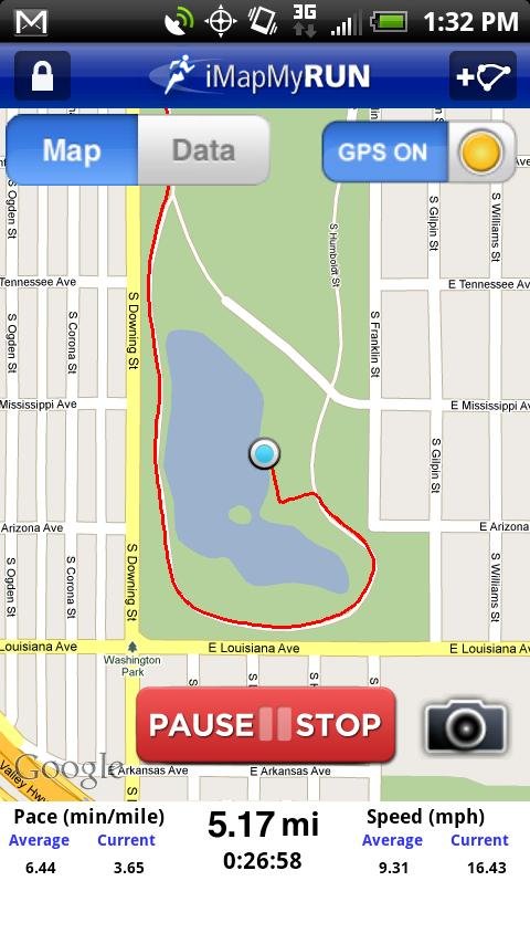
iMapMyRUN Run GPS Running Jog - iMapMyRUN+ tracks the route, distance, pace, and more in real-time using GPS.
Free new version!
iMapMyRUN+ brings you its mobile app for Android-based devices! Now owners of Android 2.1 or higher devices can track the route, time, distance, speed, pace and calories in real-time for their fitness activities using their GPS enabled mobile device.
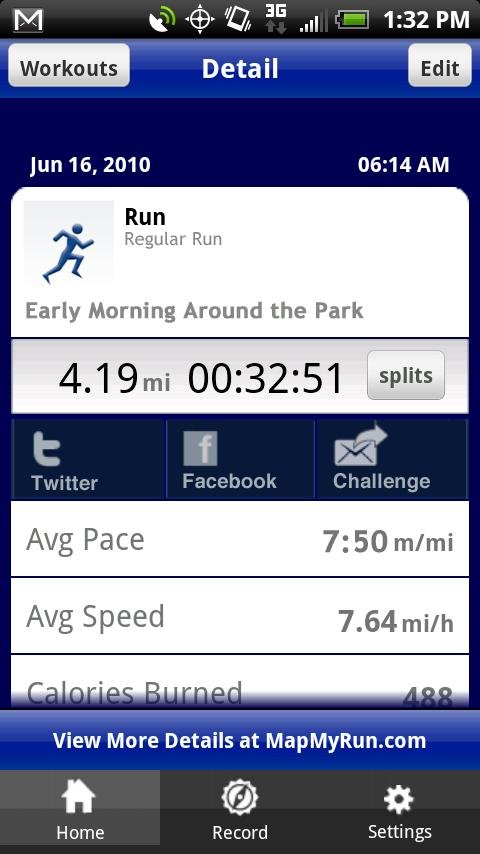
Your results sync with
www.mapmyrun.com
!
iMapMyRUN+ is great for fitness, jogging, weight loss, calorie counting, training, and more, and is an integral part of the MapMyRUN platform, by MapMyFITNESS.
Like it? Share with your friends!
Supported operating systems:
Google Android 1.5, Google Android 1.6, Google Android 10.x, Google Android 2.0, Google Android 2.1, Google Android 2.2, Google Android 2.3, Google Android 3.0, Google Android 3.1, Google Android 3.2, Google Android 4.0, Google Android 4.1, Google Android 4.2, Google Android 4.3, Google Android 4.4, Google Android 5.x, Google Android 6.x, Google Android 7.x, Google Android 8.x, Google Android 9.x
Similar Software:
geo-localise.fr Partage en temps réel de votre position GPS sur le site web geo-localise.fr
Fini les « allo, t’es ou » !
EV Speedo EV Speedo is a GPS based speedometer with gadgets to provide g-force and other GPS information.
A built in map is also provided and any of the gauges provided can be overlayed upon the map, for example use the map to show your location with a speedometer to show your current speed
JTrip JTrip - Create your own trip in Thailand. JTrip recommends attractions and directions that you need. Let's get to know Thailand together.
· select places.
· select hotel.
· show map location.
· route path form src to dest.
· taxi, time remaining.
· suggest bus number
Hunting the Snark Hunting the Snark - Inspired by Lewis Carrol's poem, The Hunting of the Snark, Hunting the Snark is an action game played on both your GPS-enabled Android device and in the real world. In it, you hunt a Snark (the creature on the map in blue.) If you invade its physical location before the game time has expired, you win. Otherwise, you lose
ViewRanger GPS ViewRanger is a unique mapping, navigation, tracking, and information tool for mobile phones that provides fully featured outdoor gps and trail navigation through a natural and intuitive display. ViewRanger transforms a Nokia or other Symbian S60 smartphone into a fully featured trail navigation system
SOS App SOS App - This app sends a text message with your GPS position (address from google maps, latitude, longitude and accuracy).The use is simple. You have to choose a contact (with the search button) and then touch the picture
NearMe NearMe application gives you a fast and easy way to find places near you. In addition, you can set the area (in Km) where to search. With every found place you have some useful options:
* Call
* Add To Contacts
* Open In Maps
* Get Directions
And other option is History: it keeps for you all places you have searched for
CoPilot Live Europe (Android) CoPilot Live Europe (Android) - CoPilot Live is full-featured voice-guided GPS navigation with Western and Eastern Europe street maps stored on your phone. Includes 3D guidance, lane assist, speed limit warnings, safety camera alerts, planning mode.
Download maps via WiFi after purchase. Unlimited use after 10 days once Google order verified
OpenGPSTracker OpenGPSTracker adds the capability to store and review where you and your Android device have been. Basically you press record at the start of your trip and your phone stores the route you take. This route is drawn real-time on the Maps functionality of Android or in the background with an idle device. The route is stored on your phone for review and further use
Geopaparazzi Geopaparazzi is a tool developed to do fast qualitative technical and scientific surveys. Its strength is its direct connection to the BeeGIS GIS, that can be used to further process the collected data.
Even if the main aim is in the field of surveying, it contains tools that can be of great use also to tourists that want to keep a geo-diary
Other Software by developer «MapMyFitness Inc.»:
MapMyRIDE GPS Cycling Riding MapMyRIDE GPS Cycling Riding - tracks the route, distance, pace, and more in real-time using GPS.
NEW: iMapMyRIDE+ for Android
iMapMyRIDE+ brings you its mobile app for Android-based devices! Now owners of Android 2
iMapMyWALK+ iMapMyWALK+ - tracks the route, distance, pace, and more in real-time using GPS.
Free new version!
iMapMyWALK+ brings you its mobile app for Android-based devices! Now owners of Android 2.1 or higher devices can track the route, time, distance, speed, pace and calories in real-time for their fitness activities using their GPS enabled mobile device
iMapMyRIDE Riding Cycling GPS iMapMyRIDE Riding Cycling GPS - iMapMyRIDE+ tracks the route, distance, pace, and more in real-time using GPS.
NEW: iMapMyRIDE+ for Android
iMapMyRIDE+ brings you its mobile app for Android-based devices! Now owners of Android 2
iMapMyFITNESS+ Fitness App iMapMyFITNESS+ Fitness App - tracks the route, distance, pace, and more in real-time using GPS.
Free new version!
iMapMyFITNESS brings you its mobile app for Android-based devices! Now owners of Android 2.1 or higher devices can track the route, time, distance, speed, pace and calories in real-time for their fitness activities using their GPS enabled mobile device


")


