Wayfinder Earth (Pocket PC) - The world in your hand! Welcome to the ultimate experience of discovering the earth on your mobile phone, for free…
How does it all work?
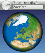
It's simple. Wayfinder Earth presents you with a 3D globe representing the planet earth, visible on the display of your mobile phone. You are able to spin the globe manually, selecting an area or city, and zoom in for a closer look. The maps of Europe and North America are detailed and you can easily zoom to street level, making any tourist map obsolete.
Thanks to Wayfinder's technology maps of the world are constantly updated and occupy limited memory space on your mobile phone. Additionally, Wayfinder Earth includes more than three million Points of Interest (POIs), such as restaurants, train stations, bars, museums, gas stations or hospitals represented as icons on the maps of Europe and North America. Simply click on an icon and get instant interactive information such as addresses, opening hours, phone numbers and more.
Together with MyWayfinder.com, the on-line route planning tool to plan your journeys, you can find POIs and share destinations with friends and family.
Like it? Share with your friends!
If you got an error while installing Themes, Software or Games, please, read FAQ.
Supported operating systems:
Windows Mobile 2003, Windows Mobile 5.0, Windows Mobile 6 Classic, Windows Mobile 6 Professional, Windows Mobile 6.1 Classic, Windows Mobile 6.1 Professional, Windows Mobile 6.5 Professional
Similar Software:
Travel Rocky Mountain National Park Travel Rocky Mountain National Park is a comprehensive travel guide illustrated with maps and photographs. Indulge Yourself with a personal tour guide on Your PDA. FREE General Information chapter and a map in the trial version.
Features
Fully illustrated.
Geology, Flora, Fauna and more.
Interesting facts.
Trail Maps and more
GPSed Pro GPSed - Mapping Your Impressions
GPSed is a service for trip tracking from mobile. In real time tracks are traced on Google maps and stored in an online archive. With a simple geotagging feature it is possible to pin photos to a map precisely at a place they were taken
Map Creator for City Advisor Map Creator for City Advisor - Create public transportation maps for use with City Advisor.
What's New in This Release:
· Enable Special TimeTable editing.
· Enable customize peeks.
· Enable CAX format map generation.
· Enable Language-Code Selection for accent insensitive search.
· Accent insensitive station search
amAze (Motorola) AmAze is a first of its kind free navigation and local search service. It is free to download and use and it contains wide coverage of maps including aerial photo in Europe, North America, Australia and parts of Asia and Africa
CarsMapper CarsMapper - This program allows you to set your home address/city/country. Then enter a local address and tap the button to view a route from or to your home location via Microsoft Live.com Service.
This program requires that you have both the 'BeanDLL.dll' file ** and ** the runtime files for Visual Basic on your PocketPC computer
BackCountry Navigator BackCountry Navigator is fun-filled navigation software for the outdoor adventurer. Use it in a variety of outdoor adventures, from kayak touring to geocaching. This is a summary of what you can do with the product.
BackCountry uses free topo and aerial maps for the United States, downloaded directly from Terraserver-USA
A-Z Mini London Street Atlas A-Z Mini London Street Atlas From the publishers of London''s best selling paperback street atlas comes this publication designed for a Windows® Mobile-based Pocket PC (version 2002 or later) and Pocket A-Z Viewer (included)
PathAway GPS SE PathAway GPS SE - GPS Navigation using your own maps! Convert any digital map, for use on your Pocket PC. Then, attach a compatible GPS (via bluetooth, cable, snap-on, or card) to your handheld, and you have a powerful GPS Moving Map navigation system
Sms My Position Sms My Position - How many times have you spend ages trying to explain somebody where to meet up, and finally not finding them? With this application you can just say: I''''ll send you an SMS with my location and we meet there SMS my Position is a very simple application that allows you to SMS your position in 3 clicks
MapBook MapBook - MapBook - store and view various maps on your Pocket PC.
MapBook requires that you have both the 'BeanDLL.dll' file ** and ** the runtime files for Visual Basic on your PocketPC computer. Simply unzip the file for your processor and place the DLL file in the 'Windows' folder of your PocketPC computer. For free support on installing, email the author
Other Software by developer «Wayfinder Systems»:
Wayfinder SpeedAlert Wayfinder SpeedAlert gives you speed camera warnings and speed alerts in your mobile with over 22.000 speed cameras in 22 countries
Wayfinder Earth (S60 2nd Edition) Wayfinder Earth (S60 2nd Edition) - The world in your hand! Welcome to the ultimate experience of discovering the earth on your mobile phone, for free.
How does it all work?
It's simple. Wayfinder Earth presents you with a 3D globe representing the planet earth, visible on the display of your mobile phone
Wayfinder Earth (S60 3rd Edition) Wayfinder Earth (S60 3rd Edition) - The world in your hand! Welcome to the ultimate experience of discovering the earth on your mobile phone, for free.
How does it all work?
It's simple. Wayfinder Earth presents you with a 3D globe representing the planet earth, visible on the display of your mobile phone
Wayfinder Earth (UIQ3) Wayfinder Earth (UIQ3) - The world in your hand! Welcome to the ultimate experience of discovering the earth on your mobile phone, for free.
How does it all work?
It's simple. Wayfinder Earth presents you with a 3D globe representing the planet earth, visible on the display of your mobile phone
Wayfinder Active (Java) Wayfinder Active (Java) is a free GPS service for mobile phones with a unique combination of maps, GPS recording and statistics, all designed for active people. With this service on your mobile, you get access to a world wide map and terrain maps for selected countries.
You record your route or training trail with just a click
Wayfinder Navigator (UIQ) Wayfinder Navigator (UIQ) - transform your mobile phone to something more useful than the ordinary GPS. With millions of points of interest and even social networking features you have a real guide that you can take with you everywhere - wherever you travel in your everyday life
Wayfinder Earth (UIQ) Wayfinder Earth (UIQ) - The world in your hand! Welcome to the ultimate experience of discovering the earth on your mobile phone, for free.
How does it all work?
It's simple. Wayfinder Earth presents you with a 3D globe representing the planet earth, visible on the display of your mobile phone
Wayfinder Navigator Wayfinder Navigator transform your mobile phone to something more useful than the ordinary GPS. With millions of points of interest and even social networking features you have a real guide that you can take with you everywhere - wherever you travel in your everyday life
Wayfinder Earth (BlackBerry) Wayfinder Earth (BlackBerry) - The world in your hand! Welcome to the ultimate experience of discovering the earth on your mobile device, for free.
How does it all work?
It's simple. Wayfinder Earth presents you with a 3D globe representing the planet earth, visible on the display of your mobile phone

")
")
")


")


")
")
")
")
")
")

")