|
WinSportsTracker is an intuitive easy to use application with powerful capabilities for touch screen Windows mobile professional phones. It is for everyone who enjoy outdoor sport activities like running, cycling, skiing, sailing, riding, hiking, rollerblading...It logs your activity speed, distance, altitude, position and many more and show on dashboard, graph or map (up to 7 views). You can save track logs for later review or export on PC (view on Google Earth, etc). WinSportsTracker helps you to improve your performance in sports. It will not affect normal operation of your mobile phone during use.
Why buy expensive sport tracking gear if you can install FREE program on your windows mobile phone?
Main program features:
-Up to 7 different tracking views
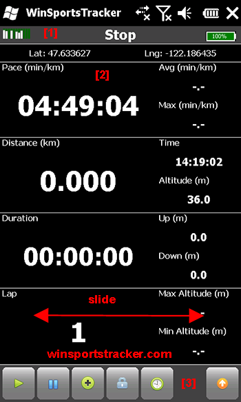
· Display speed, altitude, distance, duration, laps, calorie burn, laps statistics (current, average, max, graph display...)
· Upload to website winsportstracker.com. You can share workout with friends on Facebook
· Support different activities (running, cycling, skiing, riding, sailing,...)
· Off-road navigation. You can import route in GPX format and follow route (bearing or direction to selected point).
· Offline maps, you can download maps (OpenStreetMaps, Google maps,…) in advance on computer no need for internet connection on phone or data plan. Read FAQ on website how to download maps.
· GPX import track or route
· Activity (sport)dependent settings
· Auto lap, manual lap, lap sound
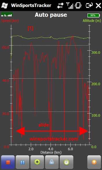
· Auto pause, manual pause, new lap on auto pause
· Add free defined way points
· Graphic display speed and altitude vs. time, altitude display relative or absolute
· Graphic display speed and altitude vs. distance, altitude display relative or absolute
· Track view on offline map (you do not need data plan on your phone)
· Measuring units: metric, imperial, nautical
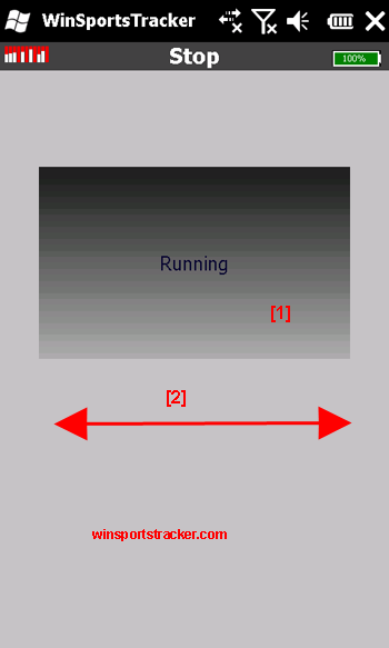
· Slide display, scroll list
· Power management long battery life
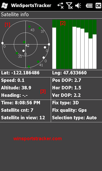
· GPS signal info (satellites, signal strength)
· Auto save track in case if battery runs out
· History of tracks
· Export track in GPX format (you can view track in Google Maps or some different app.)
· Translations
· Normal/full screen mode
· Supported resolutions: WVGA, VGA, square, WQVGA, QVGA, portrait and landscape orientations
What's New in This Release:
· Altitude display on map view
· Minimum battery settings
What's New in 3.17
· Greek translation
|
Similar Software:
|
 | Manila GPS Tracker
GPS tracker for Windows Mobile |  | trackr!
Use trackr! to let people know where you are and where you have been. All you need is the Internet, a GPS receiver and your mobile phone (or a mobile phone with an internal GPS receiver) |  | bLADE Locate
bLADE Locate - A Fire Eagle client for Windows Mobile |  | Glopus
Glopus is a program for the Pocket PC that delivers information from a GPS receiver |  | Sunset GPS Logger
Sunset GPS Logger-allows you to capture your activities (walking, running, cycling, snowboarding, hiking trails .etc) for later visualisation on Google maps. Combined with your existing digital camera it becomes an indispensable tool to simplify the process of geo-tagging those precious photos and memories |
|
 | Locify
With Locify you can explore interesting places near you from Wikipedia, seek for geocaches, display map where you are (or you want to go), twitter your location, save interesting places from phone or web sync them and even navigate to them... and much more.
Locify is free application for common mobile phone |  | TravelCompasses
TravelCompasses - TravelCompasses uses the GPS on your PocketPC to find a "Home" position. Then the program displays a compass that rotates to your current GPS. The program also displays your current compass degrees.
This program requires that you have both the 'BeanDLL.dll' file ** and ** the runtime files for Visual Basic on your PocketPC computer |  | SMSGPSing
SMSGPSing allows you to send your GPS location readings and a Google.com map link to a person via SMS |  | TravelGoogling
TravelGoogling allows you to use the GPS on your PocketPC to find 5,451 local stores and services in sorted via distance. Tap the button to start the GPS and when you get the lock tap the button to view the business directory. Tap on a business category to view local business listings. The GPS street information is from GeoNames |  | RulerGPS
RulerGPS - This program allows you to calculate the distance in Miles, Feet, Inches, KM, Meters and CM based on two latitude and longitude points. This can be used as a ruler for construction etc. with GPS.
This program requires that you have both the 'BeanDLL.dll' file ** and ** the runtime files for Visual Basic on your PocketPC computer |
|
|

")
