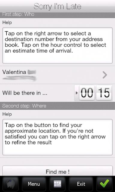
Sorry I'm Late - People are always in a hurry to get somewhere. A common issue is to inform someone waiting for us that we are, let’s say, a bit late and maybe reassure him that we will be there in some time. It would be great if we could send a message to that someone telling him our approximate location and an estimate time to reach the destination (maybe along with some excuses).
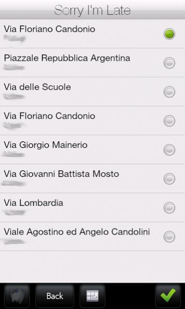
Sorry I'm Late was developed to achieve this task. This application allows a user to get his approximate location and then send it to someone else through an SMS. It has a friendly user interface and uses CellID localization instead of GPS. Also, it sends a more human readable message, unlike other similar applications which use GPS positioning to get a precise localization but then they send Latitude and Longitude coordinates or Google Maps links. This application uses street names instead of coordinates.
· Doesn't require GPS antenna
· Finger friendly UI thanks to SenseSDK from Steady Software
· Call history access to guess the most probable recipients
· Native SMS application used to send message to allow last minute changes
· Currently localized in English and Italian
What's New in This Release:
· added compression support on network calls to reduce bandwidth usage
Like it? Share with your friends!
If you got an error while installing Themes, Software or Games, please, read FAQ.
Supported operating systems:
Windows Mobile 5.0, Windows Mobile 6 Classic, Windows Mobile 6 Professional, Windows Mobile 6.1 Classic, Windows Mobile 6.1 Professional, Windows Mobile 6.5 Professional
Similar Software:
GPS4PPC GPS4PPC is an open source application, written with Basic4ppc that includes a set of tools for navigation and GPS data.
GPS4PPC supports:
- Converting coordinates between UTM and Lat / Lon.
- Converting coordinates in different datums.
- Calculating the distance and course between two coordinates.
- Show GPS data.
- Animated compass
MapSpeedometer MapSpeedometer - MapSpeedometer uses the GPS on your PocketPC to measure your speed in Km/h and says it in a computerized voice at a selectable interval. The program displays your speed in Km/h and reads it at a customizable interval rate.
This program requires that you have both the 'BeanDLL.dll' file ** and ** the runtime files for Visual Basic on your PocketPC computer
ppc PhotoGeoTag ppc PhotoGeoTag - Take pictures with your mobile phone and incorporate the data of the geographical location. The application allows you to include in the photographs, data from the GPS receiver, along with a brief note. If you know the coordinates, not having the GPS receiver, you can also handwrite geographic data
GPSMaperer GPSMaperer is a full featured map downloader. You can enter the lat/long coordinates or use your current GPS to download a map. You can download in GIF, PNG or JPEG format. The program has several options to customize the map. The map service is provided by Google
GPSLoggerer GPSLoggerer logs and displays the data that comes from your GPS unit in your device in NMEA sentences. You can select the output to a NMEA extension or or text file extension. When you select save all logs after the save will be saved to the file. When you select close the logging will stop
Mobile Speedometer Mobile Speedometer - This application is part of the author's "30 Days of .NET" initiative to develop 30 mobile applications in 30 days. The source code of the application is included in order to help programmers new to Windows Mobile development write applications in .NET
Pocket PC Geocaching Tools Pocket PC Geocaching Tools - Many tools in one program to help you while you are geocaching.
What's included?
* Open GSAK databases directly
* HTML view
* Field Notes
* Hint decoder and decryption
* Several coordinate functions
* Solver
* Transformer (Text to Digits, etc
SportsGPSer SportsGPSer - SportsGPSer can be used in a sports game to track the GPS of the players in real time via FTP server. Every second the program re-FTP's the players position to the FTP server.
This program requires that you have both the 'BeanDLL.dll' file ** and ** the runtime files for Visual Basic on your PocketPC computer
CopanMobile for PocketPC Copan for the Pocket PC - is a very functional and easy-to-use geomatics engineering tool for computing and managing plane surveying and mapping coordinates
CalculatorGPSed CalculatorGPSed - CalculatorGPSed is a GPS distance calculator and location finder. You can use the GPS or custom entry on your PocketPC to view and download GPS marked satellite camera pictures and calculates distance between two points specified by the latitude/longitude using "The Vincenty inverse formula for ellipsoids" (accuracy to within 0.5mm, or 0
Other Software by developer «ste09»:
Mobile First Aid Mobile First Aid - According to a recent study (Gray, 2008) there are abount 1.8 mobile phones per person around the world. Since everyone of us can find himself in the need to give some first aid assistance to someone injured, it is simple to merge these two data and say "why don't give these people a first aid application to be installed on their mobile phones