Tyne & Wear Metro for iPad by Zuti - The new Tyne & Wear Metro map makes it easy to travel in and around the city using the Nexus Metro system. Unlike old fashioned schematic style maps this product contains a geographically accurate central area showing major streets, parks and places of interest etc, allowing the user to easily get their bearings.
MAP
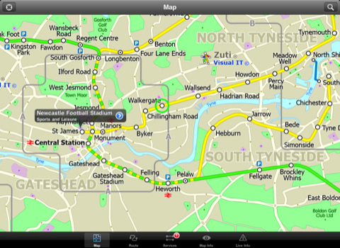
The map is hand drawn by Visual IT and provides a unique geographically based view of Tyne & Wear with many places of interest drawn directly on the background so you can easily get your bearings when traveling around the area. You can also use your inbuilt GPS to accurately locate and track yourself within the city centre and see the nearest transportation stop and distance to it. This is the only public transportation route planner with this ability.
Tap on the map for location information, use the inbuilt search feature or choose from a list of locations. Places of interest, museums, hotels, parks, restaurant, shops, hospitals, streets, etc, are also included. The route planner will automatically suggest the nearest station to any place of interest you select.
MINUTE MAP
Another great feature is the “Minute Map” option which allows you to see the travel times from a start point to all other locations on the map. This is a unique way to view the topology of an area and gauge traveling times.
ROUTING
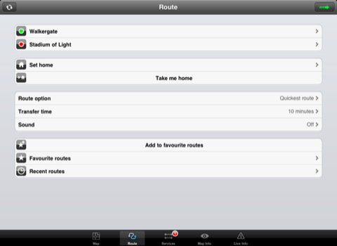
The application does not require an internet connection and will always be available to display a clear and detailed view of the city transport systems, plus list and animate the optimum route for your journey. This product provides the fastest route calculations of any mobile routing application (virtually instantaneous) using actual published journey times with the ability to select the quickest route or the route with the least changes.
LIVE INFO
When an internet connection is available, optional "Live Information" on the current state of the transport services can be viewed, allowing you to plan your journeys in advance and avoid any potential delays. Unique to this application is the ability to turn off services that are out of action and automatically calculate an alternative route.
· Full offline map and routing, no internet connection required.
· Colourful clear custom drawn geographically accurate mapping.
· Animates the route and allows tracking of the journey using GPS
· Instantly see the route of any transport service drawn on the map.
· Save and recall favourite and recent journeys.
· Take me home feature.
· Unique "Minute Map" feature allows quick view of all journey times from a start location.
· Services can be turned on or off, routing round problems.
· GPS location and tracking.
· Streets, Places of interest etc built into the application.
· Access to live service information.
What's New in This Release:
· Completely new map and routing.
· Many enhancements and added features.
Like it? Share with your friends!
If you got an error while installing Themes, Software or Games, please, read FAQ.
Supported operating systems:
Apple iOS 10.x (iPad), Apple iOS 11.x (iPad), Apple iOS 12.x (iPad), Apple iOS 4.2.x (iPad), Apple iOS 4.3.x (iPad), Apple iOS 5.0 (iPad), Apple iOS 6.0 (iPad), Apple iOS 7.0 (iPad), Apple iOS 8.x (iPad), Apple iOS 9.x (iPad), Apple iPhone OS 3.2.x (iPad)
Other Software by developer «Visual IT»:
Tube 2 Munich (Palm OS) Tube 2 Munich (Palm OS) - This map package for Tube 2 consists of a fully scrollable detailed map of the Munich metro, rail & tram system.
Plan journeys on this system, list details of the quickest routes and see a superb animated display of your journey tracking around the system map.
Munich is the capital city of Bavaria, the southern most German federal state
Tube 2 Brussels (UIQ) Tube 2 Brussels (UIQ) - This map package for Tube 2 consists of a fully scrollable detailed map of the Brussels tram, metro & bus system.
Plan journeys on these systems, list details of the quickest routes and see a superb animated display of your journey tracking around the system map
Barcelona Metro for iPad by Zuti Barcelona Metro for iPad by Zuti - This Zuti application contains a visually unique map of the Barcelona transport system and a superb animated journey planner to help you get around the TMB (Transports Metropolitan de Barcelona), FGC (Ferrocarrils de la Generalitat de Catalunya) Metro and Tram services
Washington Metro for iPad by Zuti The new Washington Metro 10 map makes it easy to travel in and around the city using the WMATA Metro, MARC and VME systems. Also included are the Potomac river taxi routes and the DC Circulator bus routes
Rough Guides Map Paris Rough Guides Map Paris... These guides are a series of fantastic interactive maps.
Produced in conjunction with the premier travel publisher Rough Guides.
Discover and explore Paris using full colour interactive linked maps, in this simple to use PDA version of The Rough Guides Paris
Tube 2 Paris Pro (UIQ) Tube 2 Paris Pro (UIQ) - This map package for Tube 2 consists of a fully scrollable detailed map of the Paris metro & RER system and linked high quality street maps of central Paris.
Plan journeys on the metro & RER system, list details of the quickest routes and see a superb animated display of your journey tracking around the system map
Tube Sydney Pro (UIQ) This award winning and highly acclaimed application that guides you around the Sydney rail system is now available for your Sony Ericsson P800 / P900 / P910 in a pro version
Tube 2 Milan (UIQ3) Tube 2 Milan (UIQ3) - This map package for Tube 2 consists of a fully scrollable detailed map of the Milan metro & rail system.
Plan journeys on this system, list details of the quickest routes and see a superb animated display of your journey tracking around the system map
Tube 2 Dublin (UIQ) Tube 2 Dublin (UIQ) - This map package for Tube 2 consists of a fully scrollable detailed map of the Dublin rail system.
Plan journeys on this system, list details of the quickest routes and see a superb animated display of your journey tracking around the system map
Tube 2 New York Geo (UIQ3) Tube 2 New York Geo (UIQ3) - This superb map package for Tube 2 is the ideal map for anyone who needs to get around New York City using the MTA subway system and would like to know just exactly where they are.
The map geographically accurately locates all of Manhattans central stations, overlaid onto a street map


")
")


")
")
")
")
")