JTrip - Create your own trip in Thailand. JTrip recommends attractions and directions that you need. Let's get to know Thailand together.
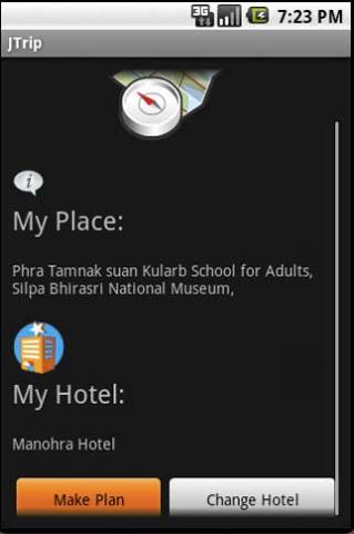
· select places.
· select hotel.
· show map location.
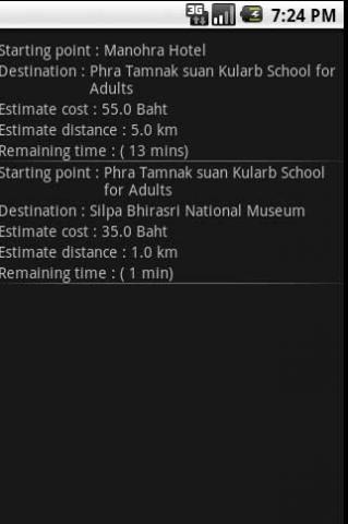
· route path form src to dest.
· taxi, time remaining.
· suggest bus number.
· suggest mrt/bts stations with gps current location.
· open facebook.
Like it? Share with your friends!
Supported operating systems:
Google Android 1.0, Google Android 1.5, Google Android 1.6, Google Android 10.x, Google Android 2.0, Google Android 2.1, Google Android 2.2, Google Android 2.3, Google Android 3.0, Google Android 3.1, Google Android 3.2, Google Android 4.0, Google Android 4.1, Google Android 4.2, Google Android 4.3, Google Android 4.4, Google Android 5.x, Google Android 6.x, Google Android 7.x, Google Android 8.x, Google Android 9.x
Similar Software:
LocationFinder LocationFinder is a LBS application. Through this application you can search any location in map. Click anywhere in map and you find the area, nearest city and country. Apart from this, user can edit any location for search and can see the location in map
Outdoor Share for Android Outdoor Share for Android - The Outdoor Navigation software is your best friend through your adventures in the wild.
Go into the outdoors with confidence and enjoy your activities without worrying about the tools to help you navigate. Your Outdoor Navigation app is made by the people who have been developing this software since 2003 across multiple platforms
TomTom U.S.A. for Android TomTom U.S.A. for Android - The TomTom app allows you to enjoy smart turn-by-turn navigation on your Android device. The application includes accurate offline maps, so you can find your way anywhere, even without an internet connection
Location Barcoder Location Barcoder is a tool for creating geocoded barcodes based on your location. Barcodes are stored on the SDCard in a folder named LocationBarcodes
InstaMapper (Android) InstaMapper is a free service that allows you to track a person or vehicle online in real time using a GPS-enabled mobile phone.
To use InstaMapper, you create a free account. Registration takes only a minute or two. All it is asked for is a username, password, and a valid email address.
Next, you install a small application on your GPS-enabled phone
meet-me FREE meet-me With only a few fingertips you can find your friends in the biggest crowd. Their location is presented by a stylish arrow and distance. Awesome: the positions are dynamically updated
Digital Dashboard GPS Digital Dashboard GPS - Features included
- Save your track info,Record gpx file(it will be saved in "sdcard/DigitalDashboardGPS/gpx/")..
- Switch between car speedometer and bike cyclometer.
- Switch between mph or km/h mode.
- Display satellites status.
- Speed chart.
- Map integration,get your location.
……
Facebook:https://www.facebook
GPSbySMS (Android) GPSbySMS is an application that reads navigation data from GPS and sends it to any user via SMS or email.
Purpose:
1) Read navigation data from GPS and send it to any user via SMS or email.
2) View current position on Maps (need Internet connection).
3) Save navigation data in database using data transfer via GPRS Internet.
4) Alarm Function
Gistory Analytics Gistory Analytics - Gistory is a powerful app that allows you to record the places you have been. In addition, you can also use the built-in analytics tool to allow you to discover how often and where you spend your time the most. Just save your current location in the app, and Gistory will take care of the rest
AlpineQuest AlpineQuest - AlpineQuest turns your Android device into an off-road GPS using offline topo maps. It is a complete solution for all outdoor activities and sports, including hiking, running, trailing, hunting, sailing, geocaching and much more
Other Software by developer «Annop Kobkij»:
not found
Comments on JTrip:
Comments not found
If you noted an error or download link is broken, please, report it via this page or use comments.
JTrip is compatible with your device uleFone Armor X Dual SIM LTE


")

")

