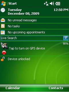
GPS2day is a today screen plug-in showing your current GPS coordinates, speed, satellite info, etc... Languages: English, Czech, Dutch, French, German, Hungarian, Italian, Japanese, Polish, Russian, Spanish.
Currently GPS2day program works as GPS informer. It supports both metric and U.S. (Imperial) units and shows a various types of information for users, such as:
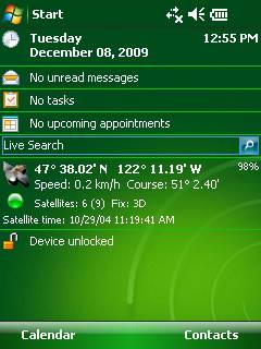
Current geographical coordinates (latitude, longitude);
Course and speed;
Some information about satellites and fix type;
Altitude followed by the fix 3D value;
Exact current date and time from the satellite atomic clock;
And battery life state which is important when you using GPS device.
What's New in This Release:
· Translation to Japanese was added
Like it? Share with your friends!
If you got an error while installing Themes, Software or Games, please, read FAQ.
Supported operating systems:
Windows Mobile 5.0, Windows Mobile 6 Classic, Windows Mobile 6 Professional, Windows Mobile 6.1 Classic, Windows Mobile 6.1 Professional, Windows Mobile 6.5 Professional
Similar Software:
e-Mobile GPS Tracker e-Mobile GPS Tracker -
System Requirements
Internet enabled Windows mobile Pocket PC with GPS.
Requires WM5 and WM6 mobile devices
PictureGPSer PictureGPSer - PictureGPSer checks the camera storage folder for new pictures/videos and when detected places the current GPS tag at the end of the image/video. You can also view the images via a distance file viewer. You can also view and download a map of the pictures from Google.com.
This program requires that you have both the 'BeanDLL
GPSBot GPSBot - This small application seems to solve the problem with TomTom navigator 7, iGO8 and other navigation programs, that shows a position of several meters back from the real one in some new devices.
Simply copy the file to the folder where the navigation program executable resides and launch this application instead of the real program
GPS Tuner Essentials Full Version with Germany, Austria, Switzerland Basic Map Content GPS Tuner Essentials Full Version with Germany, Austria, Switzerland Basic Map Content is designed specifically for off-road use: its large buttons, selectable tool window size, multiple Compass views and the built-in Tele Atlas map makes it extremely user-friendly and reliable
PictureGPSed PictureGPSed - PictureGPSed checks the camera storage folder for new pictures/videos and when detected places the current GPS tag at the end of the image/video and sends it via email with a Google.com map link. You can also view the images via a distance file viewer. You can also view and download a map of the pictures from Google.com
TextMapperer TextMapperer - TextMapperer allows you to create named text based GPS maps. When you get a GPS lock then you can create a new map and enter text for the area. When you save the text the map is downloaded and the text and GPS is appended to the end of the map with current GPS
TrakPal PitStop TrakPal PitStop - Analyse your performance using NMEA compliant GPS data recorded on your Pocket PC - the perfect complement to your GPS navigation software.
Compare data from different runs to find where those important seconds were lost, whether on the track, training, commuting or just for fun
GPS Tuner Essentials GPS Tuner Essentials is designed specifically for off-road use: its large buttons, selectable tool window size, multiple Compass views make it extremely user-friendly and reliable
TaxiAddresser TaxiAddresser uses the GPS on your PocketPC to find your current latitude/ longitude/ speed/ altitude and Googles the Address/City and allows you to send it to a preset Taxi or shuttle service via email. Tap the button to get the GPS lock and when the program gets the lock it will send the email
ShellSwitcher ShellSwitcher was implemented as a Windows Mobile system utility for fast switching between well known shells: Spb Mobile Shell, Titanium (WM6.5 default shell), Touch Flo 3D, HTC Sense and classic Today screen. This application is based on UI Switcher knowledge with some additional features