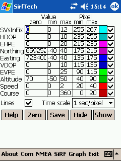
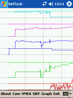
SirfTech is a Pocket PC program for checking and setting practically all SiRF GPS settings and evaluating changes.
Like it? Share with your friends!
If you got an error while installing Themes, Software or Games, please, read FAQ.
Supported operating systems:
Windows Mobile 2003, Windows Mobile 5.0, Windows Mobile 6 Classic, Windows Mobile 6 Professional, Windows Mobile 6.1 Classic
Similar Software:
DocumentGPSs DocumentGPSs - DocumentGPSs can be used to make Pocket Word documents with a GPS tag as the sheet file name. Each time you make a sheet the document it is named the latitude and longitude of your GPS. You can store your files on the storage card. You can also view the Documents with Google maps.
This program requires that you have both the 'BeanDLL
TwitterGPSes TwitterGPSes allows you to view the current GPS and status of your Twitter contacts. Enter the name of each contact to assign to a button. When you tap on the button the persons Twitter page will be downloaded and a Google.com map will display the location. This service is provided by Twitter
PouchHiker Drivers see hitchhikers and carpoolers and their destination. Hitchhikers/carpoolers can make themselves visible to drivers
uTrack uTrack - uTrack can be used to track mobile devices in a passive, non-intrusive way.
It can be used to publish the location of a Windows Mobile powered device to a widget that can be included in numerous websites including you're own. If a widget is not possible or more flexibility is required, uTrack can also be configured to publish directly to any website or webservice
Where I Am Where I Am - a small program using GPS and copies the coordinates in clipboard or builds a link for map in Google pointing to where you are now and saves it into clipboard again. Later all you have to do is only send this link. After installation you have to go to the folder containing this program, open settings
Mobitee Lite Mobitee is a mobile application intended for both skilled and beginning golfers with the purpose to diversify the game and make it accessible simultaneously allowing to raise game level
Navigation BE-ON-ROAD USA Q2/2011 Navigation BE-ON-ROAD USA Q2/2011 - The new major version of be-on-road presents new features and is based on new platform which brings high level of reliability, portability and speed on almost any kind of device. The new be-on-road brings high value voice guided door-to-door navigation
GPS Mod Driver GPS Mod Driver - This Driver installs between your GPS application and the GPSID driver that reads the hardware GPS data. Lag is compensated, by guessing your position 'some number' of milliseconds in the future, current course and speed changes are included in the guess
RulerGPS RulerGPS - This program allows you to calculate the distance in Miles, Feet, Inches, KM, Meters and CM based on two latitude and longitude points. This can be used as a ruler for construction etc. with GPS.
This program requires that you have both the 'BeanDLL.dll' file ** and ** the runtime files for Visual Basic on your PocketPC computer
Sunset GPS Logger Sunset GPS Logger-allows you to capture your activities (walking, running, cycling, snowboarding, hiking trails .etc) for later visualisation on Google maps. Combined with your existing digital camera it becomes an indispensable tool to simplify the process of geo-tagging those precious photos and memories
Comments on SirfTech:
Comments not found
If you noted an error or download link is broken, please, report it via this page or use comments.
SirfTech is compatible with your device Unitech PA968II