NaviPOWM is a car navigation system capable of running on a variety of operating systems. Only OSM based map data is supported. Realtime routing engine is planned in a later version. Geocaching and city guide functionality are also planned. other:
· more POI types
· more way types
· support more targets at once
· switch between targets by clicking on target display
· coastlines bugfixing
What's New in This Release:
fixed bugs:
· crash under Windows XP when displaying areas with holes
· areas with holes not drawn properly on Windows mobile
implemented feature requests:
· Support for gpsd
What's New in 0.2.5:
fixed bugs:
· TrackLog must show real GPSCoor
implemented feature requests:
· No aygshell.dll on PNA systems
· Show oneway arrow on streets
· Visibility of speed-pos box adjustable
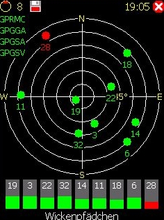
· Save received data also as GPX file
other:
· area display (sea) speedup
· reorganized directories
· support for CMake
Like it? Share with your friends!
If you got an error while installing Themes, Software or Games, please, read FAQ.
Supported operating systems:
Windows Mobile 2003, Windows Mobile 5.0, Windows Mobile 6 Classic, Windows Mobile 6 Professional, Windows Mobile 6.1 Classic, Windows Mobile 6.1 Professional, Windows Mobile 6.5 Professional
Similar Software:
Navigation BE-ON-ROAD UK and Eire Q2/2011 Navigation BE-ON-ROAD UK and Eire Q2/2011 - The new major version of be-on-road presents new features and is based on new platform which brings high level of reliability, portability and speed on almost any kind of device. The new be-on-road brings high value voice guided door-to-door navigation
FON Access Points for Martinique FON Access Points for Martinique - FON offers you a new Points of Interest service (POIs). This allows you to download FONspots directly to your navigation device.
What does that mean? You can download a Points of Interest file directly to your navigation device
PictureGPSer PictureGPSer - PictureGPSer checks the camera storage folder for new pictures/videos and when detected places the current GPS tag at the end of the image/video. You can also view the images via a distance file viewer. You can also view and download a map of the pictures from Google.com.
This program requires that you have both the 'BeanDLL
Leaf Locate Leaf Locate - Navigation in the palm of your hand
CellGPSer CellGPSer uses the cellular signal on your device to instantly find your approximate GPS. Tap the button while your phone is on and the program will send your cellular tower information to OpencCellID.org. The program will then display the approximate GPS. This service is provided by OpenCellID
BT747 MTK GPS Datalogger Device Control BT747 MTK GPS Datalogger Device Control - i-Blue 747 / i-Blue 757 / Qstarz BT-Q1000 / i.Trek Z1 / Konet BGL-32 / Holux M-241 / ... control SW (for PalmOS, WinCe (PPC), Java platform, Windows, Linux, and MacOS). Compatible with most MTK GPS based loggers
ppc PhotoGeoTag ppc PhotoGeoTag - Take pictures with your mobile phone and incorporate the data of the geographical location. The application allows you to include in the photographs, data from the GPS receiver, along with a brief note. If you know the coordinates, not having the GPS receiver, you can also handwrite geographic data
GPSSMSerer GPSSMSerer uses the GPS on your PocketPC to find your latitude/longitude/altitude and speed and creates a single blank SMS template. When the program gets its first lock then it creates an SMS with your GPS update location and a link to the Google.com mobile online street map
GeoFence MASPware GeoFence is a GPS-based surveillance tool for Windows Mobile devices. This program loads a virtual fence (GPX/KML) and starts alerts, if the current position is out of bounds.
This program can use any kind of GPX (GPS Exchange Format) data files and can also use Google KML files. You can easily record tracks with e.g
FON Access Points for South Korea FON Access Points for South Korea - FON offers you a new Points of Interest service (POIs). This allows you to download FONspots directly to your navigation device.
What does that mean? You can download a Points of Interest file directly to your navigation device
Other Software by developer «Julian Bugariu»:
not found
Comments on NaviPOWM:
Comments not found
If you noted an error or download link is broken, please, report it via this page or use comments.
NaviPOWM is compatible with your device Unitech PA968II