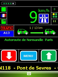
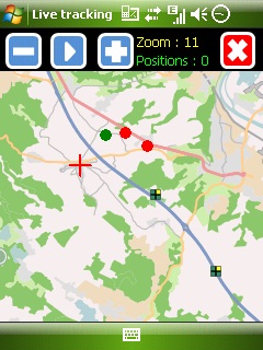
Mobbyway - Based on both internet mobile technologies and GPS, Mobbyway allows you to know easily, at any time, your relatives’ exact position on a map if they have accepted it and if they are connected to the network.
Mobbyway is also a help on the road network with a local alert system of a dangerous zone which is carried out with the network of members. Finally, Mobbyway will reference all the fixed radars in the countries where it is used and Mobbyway will indicate them to you.
Mobbyway was developed to allow:
- you to stay connected with your relatives wherever they are.
- your relatives to follow you visually and in real time.
- you to go back at any time to a place where you have already been on a specific date.
- you to travel safely on the road network thanks to the network members: The Mobbynautes.
- you to have a part in the world cartography OpenStreet Map
Like it? Share with your friends!
If you got an error while installing Themes, Software or Games, please, read FAQ.
Supported operating systems:
Windows Mobile 6 Classic, Windows Mobile 6 Professional, Windows Mobile 6.1 Classic, Windows Mobile 6.1 Professional, Windows Mobile 6.5 Professional
Similar Software:
Run.GPS Trainer UV Run.GPS Trainer is the perfect tool for sports like running, skiing and walking. It uses the Global Positioning System (GPS) to record all of your training parameters like speed, distance and altitude.
Run.GPS Trainer UV is the successor of of the award-winning Run.GPS Trainer software and has tons of new features
hdSpeedo hdSpeedo is a speedometer that is driven from a GPS signal.
· User configurable background colours
· Day/Night colour schemes (Choose by clicking on the top status bar)
· Rotatable (Portrait or Landscape)
· Gesture enabled (Move between screens)
· Point and Track logging now available as
OfficeGPSeds OfficeGPSeds - OfficeGPSeds is a full-featured Pocket Office GPS editor/viewer. When you create a new office file the current GPS is appended to the end of the file. You can view the files and edit them or edit the file and update it with your new GPS location.
This program requires that you have both the 'BeanDLL
GPSSateliter GPSSateliter displays the GPS satellite listings and strength as a graph. When you tap the 'Start GPS' button the program will look for GPS satellites and graphically display the decibel of each. The more bars the better your GPS coverage
WSpeedmeter Car speedometer for your windows mobile
TravelGPSes TravelGPSes uses the GPS on your PocketPC to find your current latitude/ longitude/ speed and altitude and looks up the Tixik.com GPS listings and displays them. Tap the button to start the GPS and when you get the lock tap the button again to view the Tixik.com listings for the area. This service is provided by Tixik
TravelGoogling TravelGoogling allows you to use the GPS on your PocketPC to find 5,451 local stores and services in sorted via distance. Tap the button to start the GPS and when you get the lock tap the button to view the business directory. Tap on a business category to view local business listings. The GPS street information is from GeoNames
3dtracking 3dtracking has revolutionized the tracking industry through the launch of it's PDA tracking software. Any Windows-based PDA (with access to an internal or external GPS receiver) can be tracked using the 3dtracking PDA software
MapDrawerer MapDrawerer allows you to download a Google.com map of your current GPS and edit it with a full-featured drawing tool. You can draw on the map and also insert text into the maps as well as use the drawing tools. The JPEG libraries are from Independent JPEG Group. The map service is provided by Google
uTrack uTrack - uTrack can be used to track mobile devices in a passive, non-intrusive way.
It can be used to publish the location of a Windows Mobile powered device to a widget that can be included in numerous websites including you're own. If a widget is not possible or more flexibility is required, uTrack can also be configured to publish directly to any website or webservice
Other Software by developer «Mobbyway»:
Mobbyway Mobbyway based on both internet mobile technologies and GPS, Mobbyway allows you to know easily, at any time, your relatives’ exact position on a map if they have accepted it and if they are connected to the network.Mobbyway is also a help on the road network with a local alert system of a dangerous zone which is carried out with the network of members


")
")