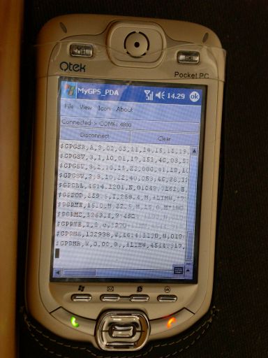
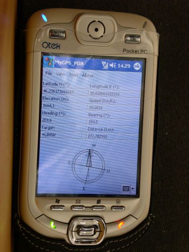
MyGPS_PDA - MyGPS_PDA is a light MyGPS version for PocketPC systems. It reads the NMEA sentences coming from a GPS antenna connected to the PocketPC and shows your position on a MyGPS calibrated map. The program can also store on a file the track log together with specific waypoints created by the user.
Like it? Share with your friends!
If you got an error while installing Themes, Software or Games, please, read FAQ.
Supported operating systems:
Windows Mobile 2003, Windows Mobile 5.0, Windows Mobile 6 Classic, Windows Mobile 6 Professional, Windows Mobile 6.1 Classic, Windows Mobile 6.1 Professional, Windows Mobile 6.5 Professional
Similar Software:
FilesGPSs FilesGPSs - FilesGPSs allows you to browse the GPS Picture/Video/Voice/Text etc. tagged files that are on your PocketPC. You can create and download a Google.com map of the folder or view each file on Google.com maps.
This program requires that you have both the 'BeanDLL.dll' file ** and ** the runtime files for Visual Basic on your PocketPC computer
FON Access Points for Estonia FON Access Points for Estonia - FON offers you a new Points of Interest service (POIs). This allows you to download FONspots directly to your navigation device.
What does that mean? You can download a Points of Interest file directly to your navigation device
FON Access Points for Czech Republic FON Access Points for Czech Republic - FON offers you a new Points of Interest service (POIs). This allows you to download FONspots directly to your navigation device.
What does that mean? You can download a Points of Interest file directly to your navigation device
Glopus Glopus is a program for the Pocket PC that delivers information from a GPS receiver
Navigation BE-ON-ROAD Central Europe Q2/2011 Navigation BE-ON-ROAD Central Europe Q2/2011 - The new major version of be-on-road presents new features and is based on new platform which brings high level of reliability, portability and speed on almost any kind of device. The new be-on-road brings high value voice guided door-to-door navigation
FON Access Points for Andorra FON Access Points for Andorra - FON offers you a new Points of Interest service (POIs). This allows you to download FONspots directly to your navigation device.
What does that mean? You can download a Points of Interest file directly to your navigation device
GPSPicturer GPSPicture allows you to create GPS stamped JPEG files and displays them in an easy to use explorer interface. When you get a GPS lock the program will display the JPEG files in order of distance to your current GPS. To view the image file simply tap on it. The map service is provided by Google
FON Access Points for Belgium FON Access Points for Belgium - FON offers you a new Points of Interest service (POIs). This allows you to download FONspots directly to your navigation device.
What does that mean? You can download a Points of Interest file directly to your navigation device
WMGpsShow Simple utility that shows/hides the GPS icon in Settings -> Connections
VirtualGPS Virtual GPS is a free, small utility, which fully emulates GPS module and returns your location (by using cellular towers).
Accuracy of coordinates is about 200m in urban area and up to 5km in countryside. Screenshots are explaining how to use VirtualGPS with navigation software (e.g. "Google Maps")
Other Software by developer «Paolo Faure Ragani, Pier Paolo Colombo»:
not found
Comments on MyGPS_PDA:
Comments not found
If you noted an error or download link is broken, please, report it via this page or use comments.
MyGPS_PDA is compatible with your device UTStarcom PPC6700 (HTC Apache)

")