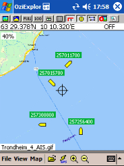
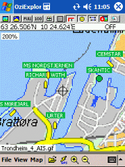
AIS2OZI - AIS2OZI tracks ship positions. It is a logger/decoder/plotter for PocketPC.
Ship positions are plotted directly in OziExplorer Download AIS2OZI (Make backup of Shiplist.txt when reinstalling.)
Decodes AIVDM sentences of types 1, 2, 3 and 5, i.e. position reports for class A shipborne equipment plus vessel information.
Like it? Share with your friends!
If you got an error while installing Themes, Software or Games, please, read FAQ.
Supported operating systems:
Windows Mobile 5.0, Windows Mobile 6 Classic, Windows Mobile 6 Professional, Windows Mobile 6.1 Classic, Windows Mobile 6.1 Professional, Windows Mobile 6.5 Professional
Similar Software:
WMGpsShow Simple utility that shows/hides the GPS icon in Settings -> Connections
SmartCaddie Pro SmartCaddie Pro with GPS
Thousands of courses, if your course is not there we will simply add it for you
12 players or more, special versions are available for leagues.
Includes enrolment for one user in the Nova Golf Internet Network (NGIN) providing further features and functions
BoatOdometers BoatOdometers - BoatOdometers uses the GPS on your PocketPC to measure your boat's speed and displays it in real time in Knots/hr, KM/hr and Miles/hr. The program also displays your latitude and longitude.
This program requires that you have both the 'BeanDLL.dll' file ** and ** the runtime files for Visual Basic on your PocketPC computer
FON Access Points for Cape Verde FON Access Points for Cape Verde - FON offers you a new Points of Interest service (POIs). This allows you to download FONspots directly to your navigation device.
What does that mean? You can download a Points of Interest file directly to your navigation device
TaxiGPSer TaxiGPSer - TaxiGPSer uses the GPS on your PocketPC to find your current latitude/longitude/speed and allows you to send it to a preset Taxi or shuttle service via email. Tap the button to get the GPS lock and when the program gets the lock it will send the email.
This program requires that you have both the 'BeanDLL
GPSRulerer GPSRulerer uses GPS to find two points and uses the "The Vincenty inverse formula for ellipsoids." (accuracy to within 0.5mm, or 0.000015"). Select 'Start GPS' to start the GPS and when you get a lock you can view your current GPS. Tap the button to save it and measure your distance. The map service is provided by Google
FON Access Points for Antarctica FON Access Points for Antarctica - FON offers you a new Points of Interest service (POIs). This allows you to download FONspots directly to your navigation device.
What does that mean? You can download a Points of Interest file directly to your navigation device
DrinkGoogler DrinkGoogler uses the GPS on your PocketPC to find the 50 closest local bars sorted via GPS distance. Tap the button to start the GPS and when you get a lock tap on it to view the list of local bars. You can also dial the bar. The GPS maps and business search service is provided by Google
WM MiniGPS WMMiniGPS is a Windows Mobile 5/6 software which gets your GPS data in a really simple gui, showing you latitude, longitude, laltitude and speed.
It can log all to file and it can export your paths to Google Earth's kml format, letting you to see where you've been, with different time intervals
GeoFence MASPware GeoFence is a GPS-based surveillance tool for Windows Mobile devices. This program loads a virtual fence (GPX/KML) and starts alerts, if the current position is out of bounds.
This program can use any kind of GPX (GPS Exchange Format) data files and can also use Google KML files. You can easily record tracks with e.g
Other Software by developer «Frank Dahlslett»:
not found
Comments on AIS2OZI:
Comments not found
If you noted an error or download link is broken, please, report it via this page or use comments.
AIS2OZI is compatible with your device UTStarcom PPC6700 (HTC Apache)

")