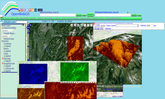
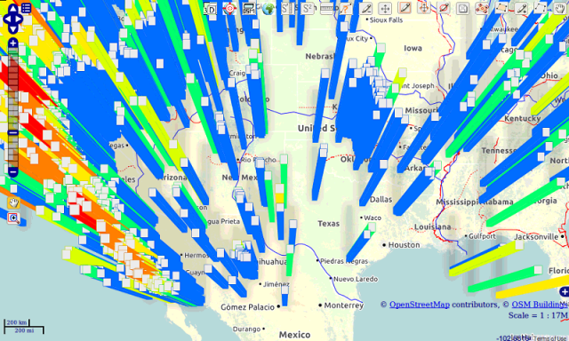
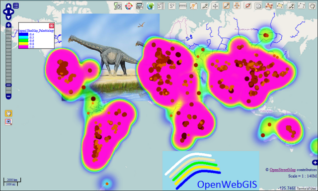
OpenWebGIS - OpenWebGIS is created for everyone who wishes to see and use a new free&open Geographic Information System(GIS). Please make your comments and suggestions. In this GIS you can use the extensive mathematical functionality to calculate and analyze your data. Using OpenWebGIS you will get a GIS at your disposal, it may be similar in functionality to some desktop GIS. Please support this project. The OpenWebGIS for Android has online and local version. In local version, you can use OpenWebGIS without having to connect to the server of OpenWebGIS and even without Internet connection. In local version, some functions do not work, but in future there will be the modification of these functions for the local version. The OpenWebGIS blog (http://openwebgisystem.blogspot.com/) provide a lot of information about possibilities for users' data operating. Full list of articles about OpenWebGIS: http://openwebgisystem.blogspot.com/2015/08/list-of-articles-about-openwebgis-in.html
Like it? Share with your friends!
Supported operating systems:
Google Android 10.x, Google Android 3.0, Google Android 3.1, Google Android 3.2, Google Android 4.0, Google Android 4.1, Google Android 4.2, Google Android 4.3, Google Android 4.4, Google Android 5.x, Google Android 6.x, Google Android 7.x, Google Android 8.x, Google Android 9.x
Similar Software:
learn QuickTest P ro learn QuickTest P ro - Learn HP QuickTest Professional (Learn HP - QTP), an automated functional testing tool that helps testers to perform automated regression testing in order to identify any gaps, errors/defects in contrary to the actual/desired results of the application under test
Learn ASP Net Learn ASP Net - ASP.NET is a web application framework developed and marketed by Microsoft to allow programmers to build dynamic web sites. It allows you to use a full featured programming language such as C# or VB.NET to build web applications easily. This tutorial covers all the basic elements of ASP.NET that a beginner would require to get started
Learn WCF Learn WCF - WCF stands for Windows Communication Foundation. It is a framework for building, configuring, and deploying network-distributed services. Earlier known as Indigo, it enables hosting services in any type of operating system process. This tutorial explains the fundamentals of WCF and is conveniently divided into various sections
Learn DOM Learn DOM - Application is divided into sections such as XML DOM Basics, XML DOM Operations and XML DOM Objects. Each of these sections contain related topics with simple and useful examples
Signals and Systems Signals and Systems - This tutorial is designed for students and all enthusiastic learners, who are willing to learn signals and systems in simple and easy steps. This tutorial will give you deep understanding on Signals and Systems concepts
Learn Data Mining Learn Data Mining - This tutorial has been prepared for computer science graduates to help them understand the basic-to-advanced concepts related to data mining. Data Mining is defined as the procedure of extracting information from huge sets of data. In other words, we can say that data mining is mining knowledge from data
Deadly Computer Viruses Deadly Computer Viruses - Getting a computer virus has happened to many users in some fashion or another. To most, it is simply a mild inconvenience, requiring a cleanup and then installing that antivirus program that you’ve been meaning to install but never got around to
Virtual/Augmented Reality Package Virtual/Augmented Reality Package - The virtual reality package is a library for virtual/augmented reality applications.
The library is currently under development and at the current stage, there is much work left to be done
Learn ebXML EbXML stands for Electronic Business XML
Comments on OpenWebGIS:
Comments not found
If you noted an error or download link is broken, please, report it via this page or use comments.
OpenWebGIS is compatible with your device ViewSonic ViewPad e70