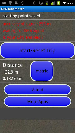
GPS Odometer - A simple and easy to use odometer. There is no maze of menus and no mysterious settings. GPS Odometer only does one thing, and does it well: measure distance traveled.
Note: Intended to measure relatively short distances, the application does not run in the background.
Like it? Share with your friends!
Supported operating systems:
Google Android 1.6, Google Android 10.x, Google Android 2.0, Google Android 2.1, Google Android 2.2, Google Android 2.3, Google Android 3.0, Google Android 3.1, Google Android 3.2, Google Android 4.0, Google Android 4.1, Google Android 4.2, Google Android 4.3, Google Android 4.4, Google Android 5.x, Google Android 6.x, Google Android 7.x, Google Android 8.x, Google Android 9.x
Similar Software:
amAze (Samsung) AmAze is a first of its kind free navigation and local search service. It is free to download and use and it contains wide coverage of maps including aerial photo in Europe, North America, Australia and parts of Asia and Africa
CoPilot Live Premium UK + IRE (Android) CoPilot Live Premium UK + IRE (Android) - Now there’s a better way to navigate.
CoPilot Live Premium is the essential voice-guided sat navigation app to get you where you need to go, by the way that suits you best.
Detailed street maps of one single European region (e.g
TomTom U.K. & Ireland for Android TomTom U.K. & Ireland for Android - The TomTom app lets you enjoy smart turn-by-turn navigation on your Android device. The application includes accurate offline maps, so you can find your way anywhere, even without an internet connection
Locate Resources Locate Resources - Why do you need Locate Resources application?
1. Locate Resources tracks, monitors and manages an individual or group of people for operational and safety security reasons.
How to start?
1. Install the application on your Android phone.
2. Create your account by providing your email id, phone number of the device, name, country and submit it.
3
InstaMapper (Android) InstaMapper is a free service that allows you to track a person or vehicle online in real time using a GPS-enabled mobile phone.
To use InstaMapper, you create a free account. Registration takes only a minute or two. All it is asked for is a username, password, and a valid email address.
Next, you install a small application on your GPS-enabled phone
Modern Compass Modern Compass this compass does what the compass always was intended to do, it helps you locate the destination of your choice.
Using GPS technology and Google maps, this application lets you mark a destination of choice and then shows in what direction that destination lies, as well as how far away it is from your current location
TomTom Italy for Android TomTom Italy for Android - TomTom Italy is a turn-by-turn GPS navigator for Android devices. The app includes accurate offline maps, so you can find your way anywhere, even without an internet connection
Speedometer GPS HD Speedometer GPS HD - Speedometer GPS HD can display more info on one screen.
Speedometer GPS HD can track your speed,distance,time,location and also can get start time,time elapased,avg speed,max speed,altitude...
Features included
- Save your track info,Record gpx file(it will be saved in "sdcard/SpeedometerGPSHD/gpx/")
CAT Scale Locator Now you can access CAT Scale locations from anywhere on your Android device! Easily Locate and Save locations based on your current GPS location or custom search!
AndNav2 (Android) AndNav2 is a navigation system for Android-powered phones. AndNav2 is based on free mapdata by OpenStreetMap.org. AndNav2 will provide full audible turn-by-turn realtime route-guidance. AndNav2 has unique features, like Text-2-Speech, an accessibility-study (aka 'Where can I get in 30 minutes') or avoiding customizable areas, i.e
Other Software by developer «TappiApps»:
My GPS Coordinates and Location My GPS Coordinates and Location - A simple application with crude, but adequate, support for 40 languages. Allows you to share your position via email, text message, twitter, etc, and displays your current GPS location in both decimal format and in sexagesimal (degrees minutes seconds) format. Internet access is not required to send your location with a text message
Name That Plane Name That Plane - Test your knowledge of aircraft. The app features over 300 aircraft images. Compete with your friends and the world via a global score board provided by Scoreloop.
How score is calculated:
score = (percentage_correct * 10) / sqrt(sqrt(time_in_seconds))
Note that only thinking time is considered
GPS Tape Measure GPS Tape Measure - GPS Tape Measure is a virtual tape measure for your Android device. Perfect for when you want to easily find the distance between two points on earth and you forgot to bring your laser rangefinder. Simple and easy to use


")
")


")


")

