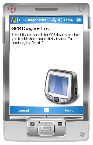
GPS Diagnostics 1.0 - These are the problems which users typically face when they're trying to get their GPS device to work:
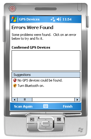
1. Users' Windows Mobile 5.0+ devices frequently have incorrect GPS Intermediate Driver settings.
2. Users are unaware that Bluetooth is turned off, or do not know how to configure a virtual serial port for their GPS device.
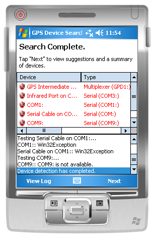
Built using GPS.NET 3.0, the utility will scan the local machine for GPS devices then make suggestions on what could be improved. Suggestions are in clear English and can be clicked to attempt a fix. This utility can:
1. Configure the GPS Intermediate Driver to correct COM: port and baud rate settings.
2. Detect when Microsoft Bluetooth is installed but turned off.
3. Suggest ideal COM: port and baud rate settings to use.
4. Recommend one device as "most reliable" when multiple devices are detected.
5. Generate log files which can (with some tweaking of code) be sent to you for further study.
Like it? Share with your friends!
If you got an error while installing Themes, Software or Games, please, read FAQ.
Supported operating systems:
Windows Mobile 2003, Windows Mobile 5.0, Windows Mobile 6 Classic, Windows Mobile 6 Professional, Windows Mobile 6.1 Classic, Windows Mobile 6.1 Professional, Windows Mobile 6.5 Professional
Similar Software:
OakLogMobile OakLogMobile - Logger application for your Windows Mobile device. Records GPS and sensor information on your phone.
The log files (*.olg) can later be loaded into TrackView.NET and viewed in all their 3D-glory.
Just copy the .exe-file onto your device manually and run it via the file explorer.
· Logs GPS position, altitude, speed, etc
ExcelGPSs ExcelGPSs - ExcelGPSs can be used to make Excel sheets with a GPS tag as the sheet file name. Each time you make a sheet the sheet is named the latitude and longitude of the file. You can store your files on the storage card. You can also view the Excels with Google maps.
This program requires that you have both the 'BeanDLL
VoicePOIer VoicePOIer - VoicePOIer is a full-featured named voice recorder with GPS location tagger. You can make named voice recordings and the GPS location is appended to the end of the file. You can browse the files via GPS distance. Tap on the wave file to play it back.
This program requires that you have both the 'BeanDLL
Mobile Altimeter Mobile Altimeter -Altimeter for windows mobile devices. We have a background that symbolizes "altitude" which is appealing to end users. Plus it gives the program a lot of style and class
ActiveStealth Safety Camera Alert software ActiveStealth Safety Camera Alert software - If you have ever found yourself thinking ?I don't remember driving that last stretch of road,? then Cheetah's brand-new driver safety software could be just the product to help your PDA or Pocket PC Phone keep you safe and ticket-free on the road
Gippos Gippos is an application for mobile devices allowing the user to locate his or her position on the map, share the location with friends and see other users on the same map. Users can also exchange instant messages with their friends
NavIt NavIt is a car navigation system with routing engine.
It's modular design is capable of using vector maps of various formats for routing and rendering of the displayed map. It's even possible to use multiple maps at a time.
Modular, touch screen friendly car navigation system with GPS tracking, realtime routing engine and support for various vector map formats
GPSDisplayer GPSDisplayer is and educational tool that displays the NMEA data that comes from your GPS unit in your device. Select the program port for your GPS and tap the start button to view the NMEA logs from your GPS. The program displays the data on viewable list
BeBack BeBack - A GPS tracking and voice navigation utility economizing the battery charge for Windows Mobile 5 or newer
Route Tracker Route Tracker - With Route Tracker you can create routes and add several route points containing text and/or images from your current position. If GPS is available it will take the current longitude, latitude and altitude. Without a GPS module information of the current cell id and the location area code are saved
Other Software by developer «Jon Person»:
GPS.NET GPS.NET is a formerly commercial .NET component maintained by GeoFrameworks, LLC from 2004 to 2009. In 2009, Jon Person decided to release the full source code of GPS.NET to the public domain for the benefit of the open source development community. This version (3.0) is the latest release
GeoFramework GeoFramework - This project was formerly a commercial library maintained by the company "GeoFrameworks" for two components it sold (GPS.NET and GIS.NET) from 2004 to 2009. In 2009, Jon Person decided to release the source code for this library in order to assist the open source community