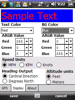
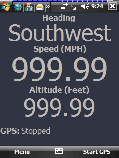
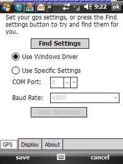
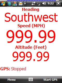
GudenSoft GPS Info An application which shows information from the GPS receiver. It uses both, the Windows Driver, and OpenNETCF's library, so if you have a GPS device, and a Windows Mobile Device, this should work
Like it? Share with your friends!
If you got an error while installing Themes, Software or Games, please, read FAQ.
Supported operating systems:
Windows Mobile 5.0, Windows Mobile 6 Classic, Windows Mobile 6 Professional, Windows Mobile 6.1 Classic, Windows Mobile 6.1 Professional, Windows Mobile 6.5 Professional
Similar Software:
FilesGPSed FilesGPSed - FilesGPSed is a file explorer for files that are GPS-tagged. You can view the distance of each file from your current GPS location ascending distance order in real time. The program updates the distance of all files every 5 seconds based on your current GPS location.
This program requires that you have both the 'BeanDLL
amAze (LG) AmAze is a first of its kind free navigation and local search service. It is free to download and use and it contains wide coverage of maps including aerial photo in Europe, North America, Australia and parts of Asia and Africa
GPRS Connection Manager This application allows you to enable/disable your GPRS connection settings
NoteGPSs NoteGPSs - NoteGPSs can be used to make voice/drawing notes with a GPS tag as the note file name. Each time you make a note the note is named the latitude and longitude of the file. You can store your files on the storage card. You can also view the note entries with Google maps.
This program requires that you have both the 'BeanDLL
FON Access Points for Philippines FON Access Points for Philippines - FON offers you a new Points of Interest service (POIs). This allows you to download FONspots directly to your navigation device.
What does that mean? You can download a Points of Interest file directly to your navigation device
Astrolabe Astrolabe uses your PDA to acquire your GPS position and send it through an SMS.
The GPS position is update every 5 seconds (in order to conserve energy).
SMSs can be sent automatically at regular time intervals
DocumentGPSs DocumentGPSs - DocumentGPSs can be used to make Pocket Word documents with a GPS tag as the sheet file name. Each time you make a sheet the document it is named the latitude and longitude of your GPS. You can store your files on the storage card. You can also view the Documents with Google maps.
This program requires that you have both the 'BeanDLL
CellGPSing CellGPSing uses the cellular signal on your device to instantly find your approximate GPS and display on a Google.com map. Tap the button while your phone is on and the program will send your cellular tower information to OpencCellID.org. The program will then display the approximate GPS. This service is provided by OpenCellID
FON Access Points for Slovakia (Slovak Republic) FON Access Points for Slovakia (Slovak Republic) - FON offers you a new Points of Interest service (POIs). This allows you to download FONspots directly to your navigation device.
What does that mean? You can download a Points of Interest file directly to your navigation device
bliinGPSXS bliinGPSXS is a free and easy software that sends your GPS-location to the bliin servers so you can be positioned Live! on the map in real-time. On bliin, users can locate and follow friends on a map in real-time, upload media: "Shares" - photos, videos, audio and text to Google Maps or other mapping services. Shares are geo-tagged to the location of capture
Other Software by developer «GudenSoft»:
Email Scheduler Email Scheduler is a simple service program for Windows Mobile devices that will automatically change your email polling settings. This means that just like ActiveSync, you can now have a schedule for all of your email accounts to check for messages
Email Scheduler Email Scheduler is a simple service program for Windows Mobile Devices that will automatically change your email polling settings. This means that just like ActiveSync, you can now have a schedule for all of your email accounts to check for messages
RadarLove! RadarLove is a simple Radar image engine that pulls all the image data from the National Weather Service RIDGE system, including most of the overlays.
A few pointers:
* you can click on a location, and it will zoom in on that location. When you do this, the map must not move, otherwise the zoom will not work


")


")


