JTrip - Create your own trip in Thailand. JTrip recommends attractions and directions that you need. Let's get to know Thailand together.
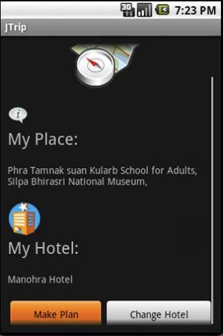
· select places.
· select hotel.
· show map location.
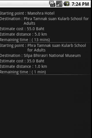
· route path form src to dest.
· taxi, time remaining.
· suggest bus number.
· suggest mrt/bts stations with gps current location.
· open facebook.
Like it? Share with your friends!
Supported operating systems:
Google Android 1.0, Google Android 1.5, Google Android 1.6, Google Android 10.x, Google Android 2.0, Google Android 2.1, Google Android 2.2, Google Android 2.3, Google Android 3.0, Google Android 3.1, Google Android 3.2, Google Android 4.0, Google Android 4.1, Google Android 4.2, Google Android 4.3, Google Android 4.4, Google Android 5.x, Google Android 6.x, Google Android 7.x, Google Android 8.x, Google Android 9.x
Similar Software:
GPShake Lite With GPShake you can track your GPS location, create GPX files, whenever you want with a shake of your phone! This means battery life saving! A great usage example could be when you want to geotagging your photo made with an external camera
SatTracx Mobile Locator SatTracx Mobile Locator helps to know your location or the whereabouts of your family, friends or your assets at anytime.
You can locate your loved ones – your children, elderly or patients at any given moment. You can also find where your buddies are and connect with them
GpsTicker Gpsticker is a program for outdoor orientation and navigation with GPS, it is best for hiking and biking. Maps are downloaded automatically from OpenStreetMaps, provided the Phone has an active internet connection
POSIT POSIT (Portable Open Search and Identification Tool) is a Humanitarian Free and Open Source Software project to use the Google Android phone as a platform for mobile disaster management applications
AntipodalPoint AntipodalPoint retrieves you position from the network provider or GPS and calculates and shows you antipodal point - the place exact opposite of you on Earth.
AntipodalPoint Pro enables you to browse the entire world and find antipodal points
ParkLeitSystem ParkLeitSystem is a car-park-routing system. It shows you, according to your GPS position, the nearest city with a car-park-routing system and gives you a list with all available car-parkings and shows how many free places there are. With a click on the parking it switches to google maps and shows you the position of the parking
GPS Tweet GPS Tweet - Share your location with a Tweet, it's easy... download and install this app, after opening it, write a message, press the Twitter logo for sharing your position on Twitter, your friend sees a link, when he clicks the link he sees your position and your message on Google Maps
Pocket Caddy Pocket Caddy - #1 Golf GPS app: 3D flyover of holes, yardage to greens, shot recording, stats, scorecard, hazard carry or lay up position. Positioning is shot to hole, not cart to hole. Free PC Analytics inc. 3D Google Earth replay with stats, and Free DIY Course Mapping software both available from www.satsportsna
MileageLedger 2.0 MileageLedger 2.0 - New features include resume trip, filtered reports, auto data export, data export via e-mail or SD card, improved GUI, increased reliability & accuracy, fault tolerance, & trip categories
Mileage Ledger is a GPS powered mileage logging application designed for Android enabled smart phones

")


")