Metro LX is a comprehensive guide to the Lisbon Subway providing:
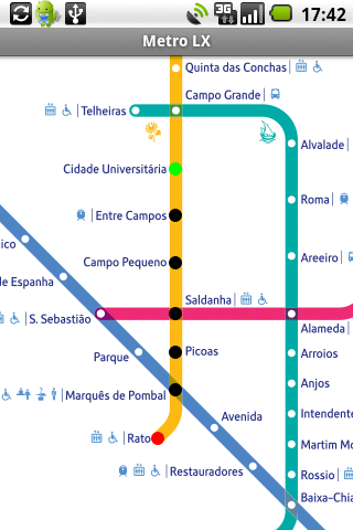
A map of Lisbon Metro (subway) in landscape and portrait modes;
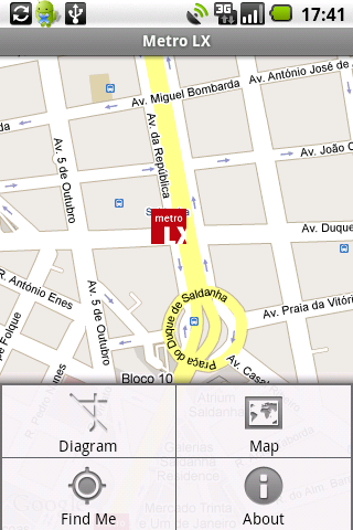
A route planner between stations;
A map route to station from your position;
And detailed information per Station.
What's New in This Release:
· Updated tariff (February 2012);
· Minor bugs fixed on tablets.
What's New in 2.8:
· Improved route to station planner;
· Updated tariff (August 2011);
· 3 new translations (Korean, Chinese and Romanian);
· Minor bugs fixed.
What's New in 2.6:
· Added preferences panel to disable/enable the use of GPS current location;
· Switch orientation crashes fixed.
What's New in 2.4:
· Minor bugs solved.
What's New in 2.3:
· Support for multiple screen sizes and resolutions.
· Layouts slightly restyled.
Like it? Share with your friends!
Supported operating systems:
Google Android 1.5, Google Android 1.6, Google Android 10.x, Google Android 2.0, Google Android 2.1, Google Android 2.2, Google Android 2.3, Google Android 3.0, Google Android 3.1, Google Android 3.2, Google Android 4.0, Google Android 4.1, Google Android 4.2, Google Android 4.3, Google Android 4.4, Google Android 5.x, Google Android 6.x, Google Android 7.x, Google Android 8.x, Google Android 9.x
Similar Software:
CoPilot Live South Africa (Android) CoPilot Live South Africa (Android) - Get a CoPilot! The onboard GPS navigation app that makes every journey better
OS Map OS Map is a tool to turn your Android phone into a handy Ordnance Survey map, with your GPS position pinpointed on it!
· Nearly all OS Map scales available (including 250,000 and 50,000).
· Touch-scrolling - simply use your finger to drag the map around.
· Fast resume from standby and fast position updates
Las Vegas DK Eyewitness Top 10 Travel Guide & Map (BlackBerry) Las Vegas DK Eyewitness Top 10 Travel Guide & Map(BlackBerry)- Save time, discover the 10 best of everything to see, buy, taste AND avoid in the Sin City Las Vegas. Plus easily make your way through the city with the included maps
Wi-Fi Map Maker - Free Wi-Fi Map Maker is application makes a map of Wi-Fi access points as you walk around.
· Maps out the actual coverage of each access point!
· Access point names are displayed on the map
· See street address and area of access points
· You can select the criteria for inclusion on your map
CopsAlarm No more tickets Show where the hiding police are on Google Map As well as speed cam,red light locations Lite shows police,red lights only
ClapCard ClapCard is a free social network for creating and sharing animated cards directly from Android based phones
Locus - addon AR This is BETA version of simple addon for Locus mapping application (version 1.1.0 and higher). Allow to show actual POI's visible on map, in Augmented reality view. In Locus Free, usage is limited to 1 minute. This addon do not have any screen or widget
Android FindMyCar Android FindMyCar - Innovative software for Android devices that uses the GPS signal to show signs that allow to reach a geographic location.
Suitable for various uses (eg. find car parked in a parking area or in an unknown city, finding a person (who has sent their coordinates) in a lovely beach, in a fair, in another boat, find an area of sea fishing, etc..)
OpenStreetMapViewer OpenStreetMapViewer provides Tools / Views to interact with OpenStreetMap-Data
AugSatNav Walk AugSatNav is an augmented reality navigation system which overlays walking directions upon a live video feed of the path or road ahead.
With AugSatNav there is no need to follow instructions or interpret maps - you can simply find your way by walking along the route highlighted by a bright white line
Other Software by developer «DFX»:
not found
Comments on Metro LX:
Comments not found
If you noted an error or download link is broken, please, report it via this page or use comments.
Metro LX is compatible with your device WellcoM A66


")

")


