TouringNavigation - It is a navigation application program for the motorcycle and the bicycle, etc.
It is a navigation application for the motorcycle and the bicycle, etc.
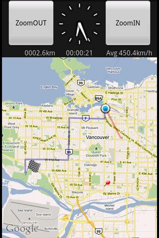
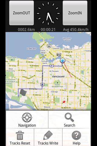
This application displays the route guide, tracks, the mileage that has been passed, the running time , and the mean time velocity.
Tracks that have been passed also provide the function to output to the SD card by the GPX format.(GPS Logger)
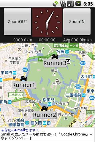
This application provides the location sharing service "Where everyone?".
"Where everyone?" is ability to understand each other, where you are now someone else on the map.
*** Let's try "Where everyone?" ***
Please push Menu button,
and tap the 'Where everyone?' button.
The Input dialog is displayed.
Input keyword 'test' and Tap 'OK' button.
The map is displayed, Please see aroud Tokyo Japan.
you can see 4 test runnners.
Like it? Share with your friends!
Supported operating systems:
Google Android 1.5, Google Android 1.6, Google Android 2.0, Google Android 2.1, Google Android 2.2, Google Android 2.3, Google Android 3.0, Google Android 3.1
Similar Software:
TapIn Places TapIn Places - its all about your daily check-in places by tap.
- View nearby places around your location.
- Shared Facebook wall posting.
- Search your favorite places simply.
- Manage recent and favorite places.
- Bookmarks your favorite places simply.
- Long click item list to view action detail.
- On map press 'S' satellite view, press 'Z' zoom control
Send My Position Send My Position is an application which shows your current location using GPS and allows you to send the coordinates using SMS as Google Maps links.
· Shows your current location using GPS
· Allows you to send your location coordinates to anyone using SMS
· Google Maps link send using SMS (Android, iPhone..
Fleet Activity Logger Fleet Activity Logger - Why do you need Fleet Activity Logger application?
- Track your fleet to increase your productivity
- View entire fleet on a single map screen
How to start?
1. Install the application on your Android phone.
2. Create your account by providing your email id, phone number of the device, name, country and submit it.
3
GPS Tweet GPS Tweet - Share your location with a Tweet, it's easy... download and install this app, after opening it, write a message, press the Twitter logo for sharing your position on Twitter, your friend sees a link, when he clicks the link he sees your position and your message on Google Maps
Mileage (Android) Mileage is a mileage tracker for an Android-powered phones. Allows importing and exporting of data in various formats, so it is easy to sync with your existing logs. Supports GPS recording
jFireEagle (Android) JFireEagle is an Android application that connects to Yahoo Fire Eagle
VGPS (Vietnamese GPS) for Android VGPS (Vietnamese GPS) for Android was designed to use city street map on your ordinary mobile phone without the need of having GPS receiver or internet connection. VGPS does not require internal or external GPS receiver. However, if you have internal GPS receiver or external bluetooth GPS receiver, VGPS can work with your GPS receiver as well
Satski Lite Satski Lite - The #1 ski/snowboard app. Real time ski navigation on 3D trail/piste maps. Imagine seeing your live GPS position, tracking & stats (speed, dist, alt). Use buddy tracking, get resort info, live weather, SOS
Pocket Caddy Pocket Caddy - #1 Golf GPS app: 3D flyover of holes, yardage to greens, shot recording, stats, scorecard, hazard carry or lay up position. Positioning is shot to hole, not cart to hole. Free PC Analytics inc. 3D Google Earth replay with stats, and Free DIY Course Mapping software both available from www.satsportsna
Other Software by developer «kazuhito kawabe»:
not found
Comments on TouringNavigation:
Comments not found
If you noted an error or download link is broken, please, report it via this page or use comments.
TouringNavigation is compatible with your device WellcoM A69


")
")
 for Android")

