Athens Transportation - Information and tracking of buses, trolleys, tram, subway and trains lines/stops in Athens, Greece. English description at the end.
Η εφαρμογή περιέχει τις γραμμές και τις στάσεις όλων των μέσων αστικών συγκοινωνιών της Αθήνας (λεωφορεία, τρόλεϊ, τραμ, μετρό, ηλεκτρικός και προαστιακός).
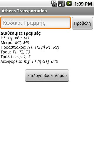
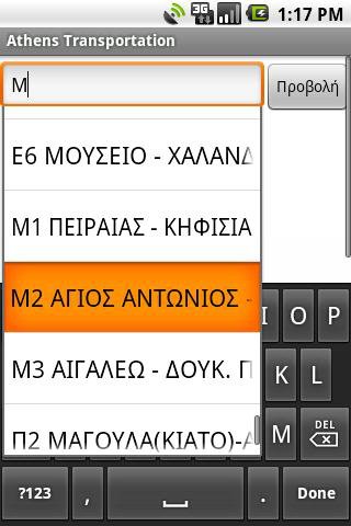
Δίνει την δυνατότητα στο χρήστη να επιλέξει τη γραμμή που επιθυμεί γράφοντας απευθείας τον κωδικό ή το όνομα της, είτε επιλέγοντάς την από τη λίστα βάσει του Δήμου που εξυπηρετεί.
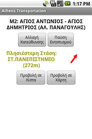
Στη συνέχεια μπορεί να δει ποια είναι η πιο κοντινή στάση στην τωρινή τοποθεσία του, με υπολογισμό της απόστασης από αυτή και ένδειξη της κατεύθυνσης, κάνοντας χρήση του ενσωματωμένου GPS και πυξίδας της συσκευής. (Απαιτεί να βρίσκεται σε απόσταση έως 1.5 χιλιόμετρο περίπου από την κοντινότερη στάση).
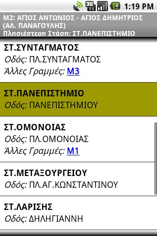
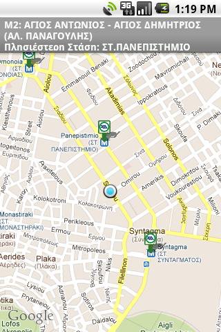
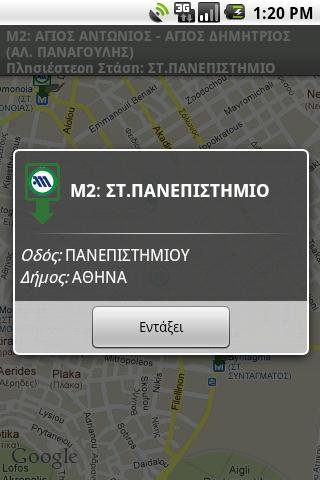
Οι στάσεις της επιλεγμένης γραμμής εμφανίζονται σε λίστα ή σε Χάρτη Google (απαιτεί σύνδεση στο Διαδίκτυο). Στη συνέχεια υπάρχει ενημέρωση σε πραγματικό χρόνο του ποια στάση βρίσκεται αυτή τη στιγμή και ποια είναι η επόμενη.
Επιπλέον Χαρακτηριστικά:
* Λειτουργεί χωρίς πρόσβαση στο Διαδίκτυο (εκτός των Χαρτών Google)
* Πολύ μικρό μέγεθος στη συσκευή, 200kb+, αν επιλεχτεί ως σημείο μεταφόρτωσης της βάσης η κάρτα μνήμης
Προσοχή:
* Η εφαρμογή περιέχει λάθη και παραλείψεις. Όταν συναντάτε κάποιο, επικοινωνήστε μαζί μου ώστε να το διορθώσω!
* Τα δεδομένα προέρχονται από την ιστοσελίδα του ΟΑΣΑ και περιέχουν επιπλέον διορθώσεις.
* Ο προγραμματιστής και η εφαρμογή ΔΕΝ έχουν καμία σχέση με τον ΟΑΣΑ.
* Ουδεμία ευθύνη φέρω για... αγνοούμενους στην Αθήνα :)
ENGLISH DESCRIPTION
The application contains the Lines and Stops off all public transports of Athens, Greece (busses, trolleys, tram, subway, electric railway and suburbian railway).
It lets user choose the Line they want, either by writing directly it's code or name, or selecting it from the list of municipalities it crosses.
Next they can see which is the closest stop to their current location, with calculation of distance and direction towards it, by using the embedded GPS and compass of the device. (It requires to be within a distance of about 1.5km (1 mile) from the closest stop).
The stops of the selected line can be displayed in a list or on Google Map (requires Internet connection). Then realtime information is displayed about which stop they are currently in and which stop comes next.
Additional Features:
* Works without Internet access (except for Google Maps)
* Very small installation footprint in device, 200kb+, if the External Storage is selected as the save point for the Database.
Note:
* The application contains errors and lacks information. When you come across any of them, contact me so I can fix them!
* The data originate from the website of OASA
http://www.oasa.gr
and contain additional fixes.
* The programmer and the application are NOT affiliated to OASA in any way.
* I can't be held liable for any... missing persons in Athens :)
Like it? Share with your friends!
Supported operating systems:
Google Android 1.5, Google Android 1.6, Google Android 2.0, Google Android 2.1, Google Android 2.2, Google Android 2.3, Google Android 3.0, Google Android 3.1
Similar Software:
Yandex.Metro Yandex.Metro - Find the quickest metro route.
Stand-alone interactive metro map.
Quickly navigate the metro systems of Moscow, Saint Petersburg, Kiev, Kharkiv and Minsk.
Get an estimation of your journey time and even find out which carriage to sit in to avoid lengthy walks to the other end of the platform.
The Yandex
TraffiCam TraffiCam will allow Android phone users to snap traffic picture using traffic cameras which have been installed in Malaysia
Trafikanten Offisiell Trafikanten Offisiell - Trafikanten provides real-time departures deviation messages and travel planner for boats, bus, subway and trams in Oslo and Akershus. It also provides real-time departures and deviations for train in Eastern Norway. Stations can be found using the position of the phone or by search for the name of the station
Hotelbooklet.com - Compare Hotel Rates - Firefox Addon Hotelbooklet.com - Compare Hotel Rates - Firefox Addon - A free hotel comparison tool which compares hotel offers of more than 30 top reservation sites and shows all available rates. It is the easiest way to find the cheapest hotel room rates over the Internet and make a direct booking
SYNC® Destinations SYNC® Destinations • Turn-by-Turn Route Guidance via SYNC® Traffic, Directions and Information Services • Destination Management (download destinations, access contacts, conduct business searches)
Transportoid WARNING! Polish language only! Public transport routes and schedules for Warszawa, Kraków, Wrocław and 49 other polish cities - more are coming! Application works offline, shows data in a very convenient way
Reisplanner Reisplanner is a (Dutch) public transport schedule application for Android devices
TripIt TripIt Travel Organizer puts all your travel plans right on your Android
NYCMate (NYC Bus & Subway) NYCMate (NYC Bus & Subway) - Real subway times, Bus, NJT, MetroNorth and LIRR schedules.
Tweet questions, compliments, complaints and support requests @nycmate
UPDATED APPLICATION
The wait is over!! We have been hard at work here at Densebrain and we are so excited to release our newest update to NYCMate
MonTransit MonTransit brings STM buses and subways information in your pocket. Please, if the app doesn't work on your Android device, contact us via email, Twitter or Facebook. This app is open-source and not related with the Societe de Transport de Montreal. The app is ads supported
Other Software by developer «Kostas Tzounopoulos»:
not found
Comments on Athens Transportation:
Comments not found
If you noted an error or download link is broken, please, report it via this page or use comments.
Athens Transportation is compatible with your device WellcoM A69


")
