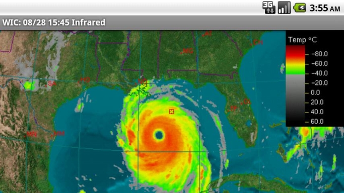
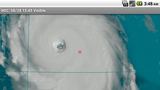
Where's It Cloudy is an Android application that shows real-time satellite data from the American Geostationary Weather Satellites. As a mobile phone application, you may access it to find out where it's cloudy in the vicinity of where you are located, or anywhere in the eastern and central United States and southern Canada. Most other weather apps do not show satellite imagery; they only show radar data. Radar data is effective at showing where there is rain and snow, but it doesn't show where clouds are located. Currently the App will NOT show imagery covering the West Coast.
The satellite data shown in Where's It Cloudy? is ideal for several purposes including:
· showing cloudy regions
· detecting the likelihood of precipitation
· helping track moderate to severe storms and hurricanes
· showing the movement, rotation, and structure of storms
· display of images in a time-lapsed loop.
Traditional weather applications show imagery covering only predefined areas at predefined resolutions. Where's It Cloudy? goes beyond this to allow the user to choose a default viewing point anywhere in North America, and a viewing altitude that determines the area the image will cover. A cloud computing platform renders the data based on your selections. The Cloud for Clouds!!
Once you set your default location and altitude, the image loops are dynamically generated at the maximum possible resolution from a 3D model of the Earth with the real time satellite imagery overlaid on this realistic model. This provides stunning and accurate visuals, especially in the Visible channel of satellite data.
Unlike other programs that may show the satellite imagery in a few shades at a reduced level of detail Where's it cloudy shows satellite imagery in full detail and in as many shades as are possible on your device. We also do not use lossy compression to preserve as much detail as possible.
If you select Tru-Sat Image it will show the raw satellite image as it was imaged from the satellite which in many cases can show much more detail. Give it a try you will be impressed.
What's New in This Release:
· Image Times are now in local time as determined by your devices time zone setting.
Like it? Share with your friends!
Supported operating systems:
Google Android 1.5, Google Android 1.6, Google Android 10.x, Google Android 2.0, Google Android 2.1, Google Android 2.2, Google Android 2.3, Google Android 3.0, Google Android 3.1, Google Android 3.2, Google Android 4.0, Google Android 4.1, Google Android 4.2, Google Android 4.3, Google Android 4.4, Google Android 5.x, Google Android 6.x, Google Android 7.x, Google Android 8.x, Google Android 9.x
Similar Software:
Tokyo Amesh This application shows the real-time rainfall data provided by Tokyo Metropolitan Government Bureau of Sewerage. The data is updated in every 10 minutes automatically. Version 1.2.1: fixed time range of images Version 1.2.0: supports zoom control, pre-load and caching images
Earthquake Alert! Earthquake Alert! - See the latest Magnitude 1.0 and higher earthquakes from all over the World.
Features
- Tab between map and list
- Latest quakes in the World
Weather for Switzerland Weather forecast LIVE detailed and updated several times a day for Switzerland. Find quickly and easily every day the weather forecast LIVE detailed and updated several times a day for Switzerland. - Temperature - Limit of snowfall
WeatherEye Get Weather Forecast,Severe Weather Alerts.Multiple City Access+submit photos. 14 day trend for Canadian cities Submit photos to The Weather Network, for display on TV and Online Includes:Wx Widgets, Radar Maps, GPS locator
Swiss Weather Radar Swiss Weather Radar - This application allows to show the radar animation of the rainfalls in Switzerland.
The coverage is limited to SWIZERLAND AND ITS BORDER AREAS
EmWeather EmWeather is a free, open-source, Canadian weather application for Android that uses Environment Canada weather feeds for its data.
It displays the current conditions as well as 8 forecasted conditions with the ability to quickly read the full details for each forecast. Very detailed extra forecast information is available through the menu
Aix Weather Widget Detailed 24-hour weather forecast in a 4x1 widget. Detailed weather forecast for the following 24 hours in a 4x1 widget. Temperature, maximum/minimum rain, weather conditions and sun rise/set times are shown
GO Weather Widget Skin HTC GO Weather Widget Skin HTC - A new theme of widget skin designed for GO Weather, HTC Style.
This is not a standalone app, you need to download latest amazing GO Weather v1.9.1 (or above) in order to apply this theme;You can check GO Weather out by searching "GO Weather" in google market
Hava Durumu Türkiye Hava Durumu Türkiye - Hava Durumu uygulamasında tüm şehirlerin hava durumunu detaylı inceleyebilir, basınç, rüzgar ve nem miktarını anlık olarak görüntüleyebilirsiniz. Gününüzü havaya göre planlayabilirsiniz
Datos Meteo Galiza Datos Meteo Galiza - Fai frío? Onde chove? O tempo en Galicia.
Os datos das estacións meteorolóxicas de Meteogalicia.
Podes ver a previsión dos próximos días por localidades ou toda Galicia
Other Software by developer «Aquila Systems»:
not found
Comments on Where's It Cloudy:
Comments not found
If you noted an error or download link is broken, please, report it via this page or use comments.
Where's It Cloudy is compatible with your device WellcoM A69