VGPS (Vietnamese GPS) for Android was designed to use city street map on your ordinary mobile phone without the need of having GPS receiver or internet connection. VGPS does not require internal or external GPS receiver. However, if you have internal GPS receiver or external bluetooth GPS receiver, VGPS can work with your GPS receiver as well. VGPS does not require internet connection so you no need to worry about connection charge.
· Offline map (totally offline application. VGPS only uses internet to validate your purchase when you activate demo version become full version. Other than that the application will never use internet)
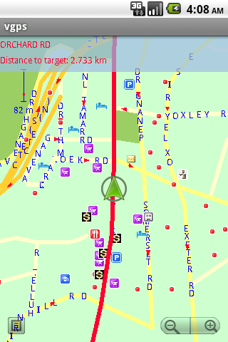
· Map data from Garmin and OpenStreetMap
· Zoom in/Zoom out/Pan
· Search point by name,type,distance or mix type+name, type+distance
· Can touch any object on the map
· GPS real-time tracking
· Routing point to point
· Rotate map so the driving direction (heading) is always up
· Voice guidance (turn left/turn right)
What's New in This Release:
· User can take screenshot and save to memory card
What's New in 7.0:
· Supports all android phones and tablets screen sizes and densities (android 1.5 to android 3.2+)
What's New in 6.9:
· pinch to zoom in/out
Like it? Share with your friends!
Supported operating systems:
Google Android 1.5, Google Android 1.6, Google Android 10.x, Google Android 2.0, Google Android 2.1, Google Android 2.2, Google Android 2.3, Google Android 3.0, Google Android 3.1, Google Android 3.2, Google Android 4.0, Google Android 4.1, Google Android 4.2, Google Android 4.3, Google Android 4.4, Google Android 5.x, Google Android 6.x, Google Android 7.x, Google Android 8.x, Google Android 9.x
Similar Software:
AlpineQuest AlpineQuest - AlpineQuest turns your Android device into an off-road GPS using offline topo maps. It is a complete solution for all outdoor activities and sports, including hiking, running, trailing, hunting, sailing, geocaching and much more
ViewRanger GPS ViewRanger is a unique mapping, navigation, tracking, and information tool for mobile phones that provides fully featured outdoor gps and trail navigation through a natural and intuitive display. ViewRanger transforms a Nokia or other Symbian S60 smartphone into a fully featured trail navigation system
My Tracks My Tracks - Use My Tracks while you run, bike, hike, or do anything else outdoors, and it will use the GPS sensor in your Android phone to record the path you took. It will also gather useful statistics such as time, speed, distance, and elevation. You can review all of this data live, or you can save it for use later
Open GPS Tracker Open Source recording, storing and accessing of your routes: Open GPS TrackerAn application that can track your travels of your Android by storing your GPS locations. Draws the route real-time on either Google or OSM maps
Red Panic Button (Android) Red Panic Button - When you are in trouble press the Red Panic Button! You just have to set a panic number and the mobile phone will send a sms which contains a link to Google Maps with your fine GPS based or coarse GSM based coordinates.
What's New in This Release:
· New Feedback button!
· QVGA and WVGA screen layout improvements!
What's New in 2
Glympse Glympse - Safely share your location in real-time via email, SMS, Facebook, or Twitter.
"Glympse: The Coolest Thing Your Smartphone Can Do"
-FastCompany
Glympse is the easy way to safely share your location in realtime. No sign-up needed. No social network to manage. Just send a Glympse to anyone via email, SMS, Facebook, or Twitter
MapMyHike+ for Android MapMyHike+ for Android - MapMyHike is a mobile assistant designed to allow hikers to track their activities using their phone's built-in GPS.
With the app you can view your route on a map and record your trip details, including duration, distance, pace, speed and elevation.
You can also share the details of your activity with friends via Facebook, Twitter or email
Navitel Navigator Android “Navitel Navigator” is a unique and accurate navigation system. Detailed Russia map. Free traffic jams information service. SPEEDCAMs. The most detailed map of Russia: more than 118 000 cities and towns, 1500 of them contain address search information. The most detailed Moscow and Saint-Petersburg map
Android FindMyCar Android FindMyCar - Innovative software for Android devices that uses the GPS signal to show signs that allow to reach a geographic location.
Suitable for various uses (eg. find car parked in a parking area or in an unknown city, finding a person (who has sent their coordinates) in a lovely beach, in a fair, in another boat, find an area of sea fishing, etc..)
Other Software by developer «Vietnamese GPS»:
VGPS (Vietnamese GPS) VGPS (Vietnamese GPS) - was designed to use city street map on your ordinary mobile phone without the need of having GPS receiver or internet connection. VGPS does not require internal or external GPS receiver. However, if you have internal GPS receiver or external bluetooth GPS receiver, VGPS can work with your GPS receiver as well
VGPS (Vietnamese GPS) for Android VGPS was designed to use city street map on your ordinary mobile phone without the need of having GPS receiver or internet connection. VGPS does not require internal or external GPS receiver. However, if you have internal GPS receiver or external bluetooth GPS receiver, VGPS can work with your GPS receiver as well


 for Android")
 for Android")


")


")
 for Android")