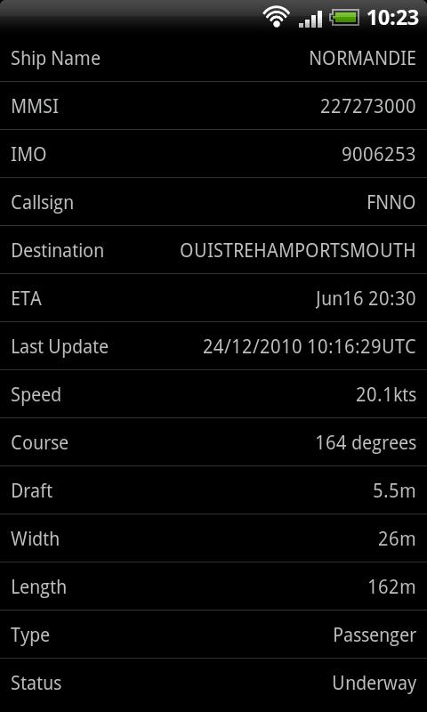
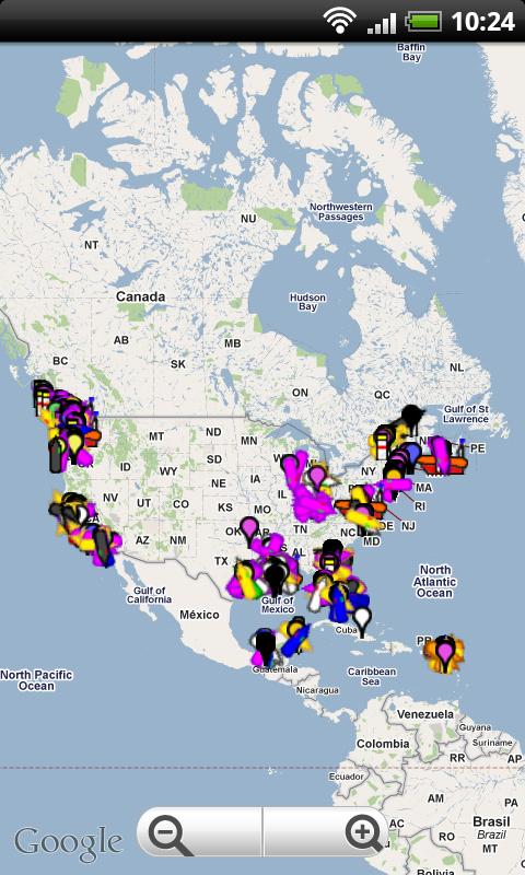
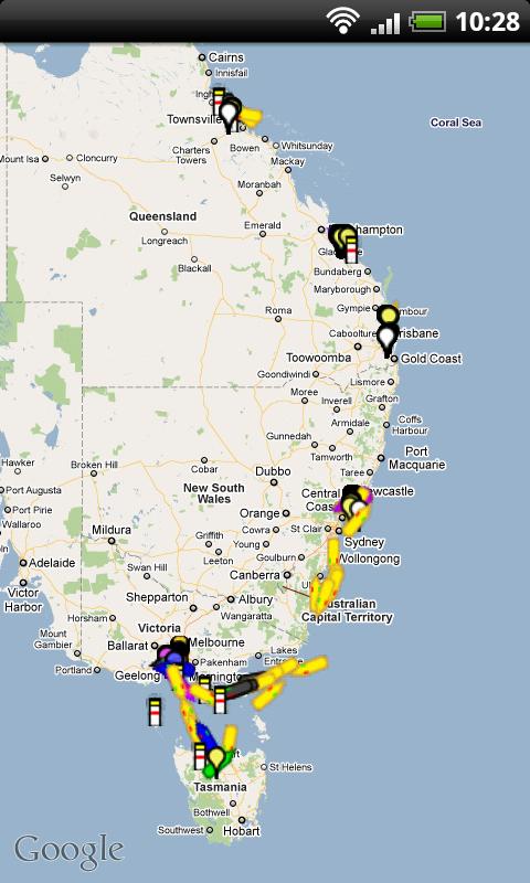
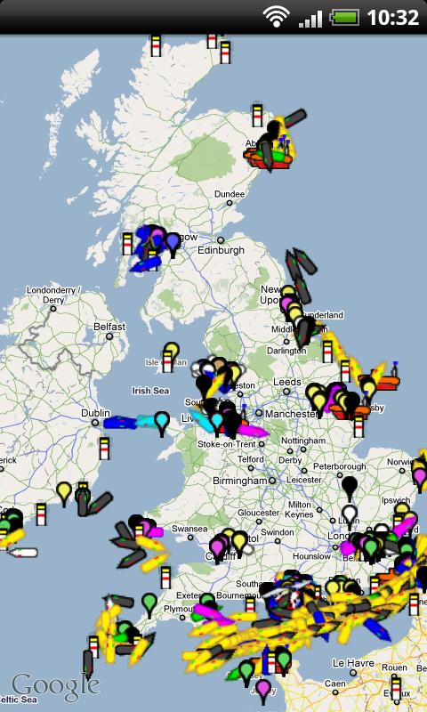
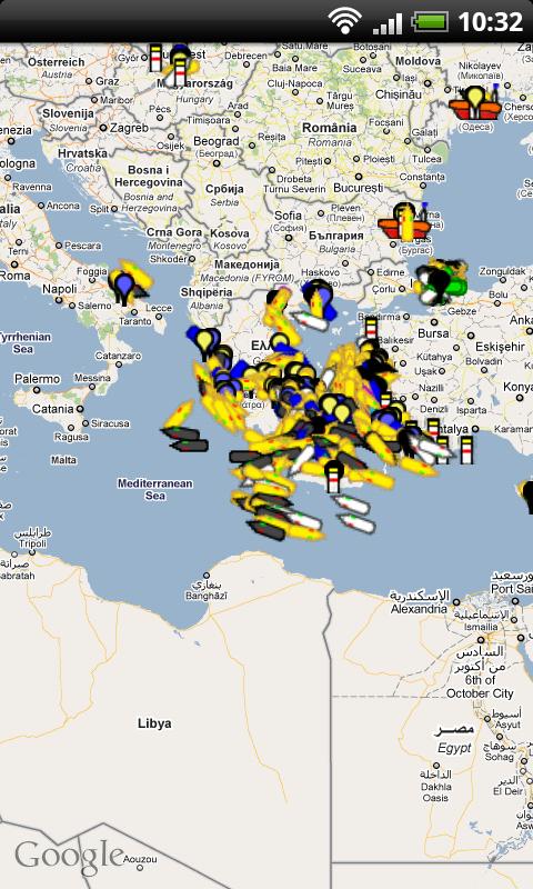
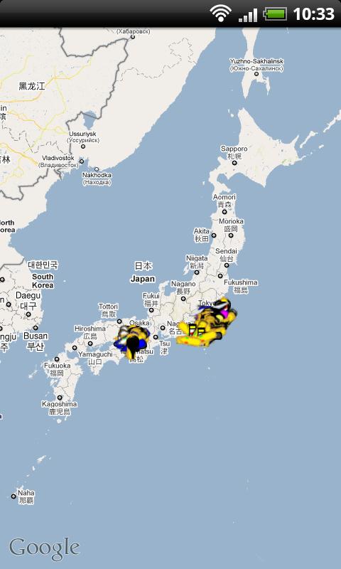
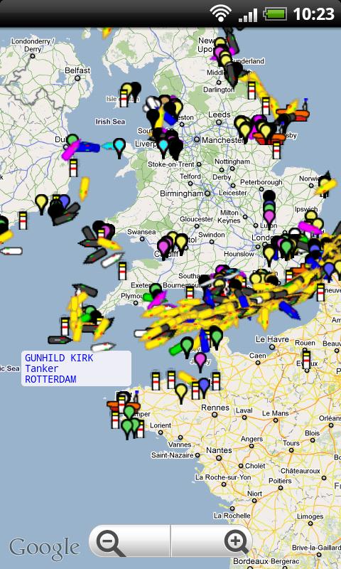
Ship Finder for Android - Ship Finder is a useful application that allows you to track ships in near real-time on a 2D map.
Tap on a ship to view its name, port of registration, destination, ETA, location, MMSI, IMO, callsign , heading, length, width, draft, etc.
The app works by picking up AIS feeds used by the ships for safety and navigation purposes.
What's New in This Release:
· Fixed the crashing when low/no signal
Like it? Share with your friends!
Supported operating systems:
Google Android 1.6, Google Android 10.x, Google Android 2.0, Google Android 2.1, Google Android 2.2, Google Android 2.3, Google Android 3.0, Google Android 3.1, Google Android 3.2, Google Android 4.0, Google Android 4.1, Google Android 4.2, Google Android 4.3, Google Android 4.4, Google Android 5.x, Google Android 6.x, Google Android 7.x, Google Android 8.x, Google Android 9.x
Similar Software:
GPS Share GPS Share Have you ever been trying to meet friends in a large public space, but been unable to find each other? GPS Share was created for just such a scenario.
Use GPS Share to share your location how you want, whether it’s SMS, Email, Twitter, or something else. Because GPS Share uses no external services besides Google Maps, your privacy isn’t a concern
SatTracx Mobile Locator SatTracx Mobile Locator helps to know your location or the whereabouts of your family, friends or your assets at anytime.
You can locate your loved ones – your children, elderly or patients at any given moment. You can also find where your buddies are and connect with them
GPS Essentials Turn your phone into a fully-featured GPS receiver!
LAS MobileTracker LT LAS MobileTracker LT - The LAS MobileTracker LT is an easily configured app to read GPS coordinates from an Android OS phone or tablet. Every five minutes, the coordinates and user ID are uploaded to our website from anywhere on the planet that has internet access. A GeoTag button also takes a ''snapshot'' of your location
CoPilot Live UK + Ireland (Android) CoPilot Live UK + Ireland (Android) - CoPilot Live is full-featured voice-guided GPS navigation with street maps of 1 European region stored on your Android phone. Includes 3D guidance, lane assist, speed limit warnings, safety camera alerts, planning mode.
Download maps via WiFi after purchase. Unlimited use after 10 days once Google order verified
Polaris Navigation System Polaris Navigation System - The Polaris Navigation System is a powerful navigation software for Android. It includes all the standard GPS functionality, including an odometer, altimeter, speedometer and directional compasses.
The app also allows you to record trails and view them on a map
GeoBeagle GeoBeagle is a free, open source application for the Android platform to aid users in finding geocaches and letterboxes. It enables the user to do paperless geocaching.
Geocaches and letterboxes are objects that have been hidden in the real world; the game of geocaching/letterboxing is finding these objects around you
uWho Find Me uWho Find Me will send a text message with your current location to help people find you.Simply have your friend or family member send you a text with your uWho Find Me Access code as the body of the text and your current location will be sent back.
Notes:
Application runs on phone boot up
Weather Forecast USA Weather Forecast USA- Displays 7-day forecast for any location in US (Alaska, Puerto Rico, Hawaii and Guam included). Location is determined via GPS on your device, so don''t forget to turn it on. Forecast is obtained from NOAA web services where it is refreshed hourly
Mobilex GPS Logger Mobilex GPS Logger - Overview ========================== The Android GPS Logger application captures GPS updates, and saves latitude and longitude coordinate fixes to text files on micro SD card. Supported Features inlcude: ============================== Google Maps. Satellite, Traffic and Street Views
Other Software by developer «pinkfroot»:
Plane Finder 3D for iPhone/iPad Plane Finder 3D for iPhone/iPad - Plane Finder 3D is a flight tracker that shows live air traffic in beautiful 3D.
With simple touch controls you can pan and zoom to fly around the planes, and can even get on board a plane for a captain's eye view from the cockpit
Plane Finder for iPhone Plane Finder for iPhone - Plane Finder is a flight tracker that shows real-time air traffic on a 2D map.
Tap on a plane to view airline, flight number, route, speed and altitude, aircraft information, departure and arrival data, etc.
The app allows you to search for more than 12,000 aircraft, which are tracked in real-time using ADS-B data
Plane Finder for Android Plane Finder for Android - Plane Finder is a flight tracker that shows real-time air traffic on a 2D map.
Tap on a plane to view airline, flight number, route, speed and altitude, aircraft information, departure and arrival data, etc.
The app allows you to search for more than 12,000 aircraft, which are tracked in real-time using ADS-B data
Plane Finder Free for iPhone Plane Finder Free for iPhone - Plane Finder Free is a flight tracker that shows real-time air traffic on a 2D map.
Tap on any plane to view flight number and plane registration / tail number.
The app can show the location of more than 12,000 aircraft, which are tracked in real-time using ADS-B data
Plane Finder 3D for Android Plane Finder 3D for Android - Plane Finder 3D is a flight tracker that shows live air traffic in beautiful 3D.
With simple touch controls you can pan and zoom to fly around the planes, and can even get on board a plane for a captain's eye view from the cockpit.
The app allows you to search for more than 12,000 aircraft, which are tracked in real-time using ADS-B data
Plane Finder HD for iPad Plane Finder HD for iPad - Plane Finder is a flight tracker that shows real-time air traffic on a 2D map.
Tap on a plane to view airline, flight number, route, speed and altitude, aircraft information, departure and arrival data, etc.
The app allows you to search for more than 12,000 aircraft, which are tracked in real-time using ADS-B data
Ship Finder HD for iPad Ship Finder HD for iPad - Ship Finder is a useful application that allows you to track ships in near real-time on a 2D map.
Tap on a ship to view its name, port of registration, destination, ETA, location, MMSI, IMO, callsign , heading, length, width, draft, etc.
The app works by picking up AIS feeds used by the ships for safety and navigation purposes


")


