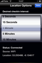
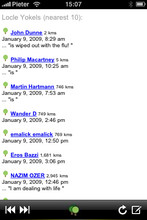
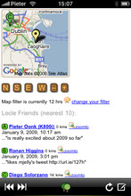
Locle is a mobile application that lets users see where their friends and family are without the need for GPS. Wherever you are, always find out where people are and meet them for lunch, drinks or whatever you want to do. Just make sure you don't miss out on anything.
Like it? Share with your friends!
If you got an error while installing Themes, Software or Games, please, read FAQ.
Supported operating systems:
Google Android 1.0, Google Android 1.5, Google Android 1.6, Google Android 10.x, Google Android 2.0, Google Android 2.1, Google Android 2.2, Google Android 2.3, Google Android 3.0, Google Android 3.1, Google Android 3.2, Google Android 4.0, Google Android 4.1, Google Android 4.2, Google Android 4.3, Google Android 4.4, Google Android 5.x, Google Android 6.x, Google Android 7.x, Google Android 8.x, Google Android 9.x, Java ME, Java Nokia 240x320, Java SE 240x320, Palm OS 3.x, Palm OS 4.x, Palm OS 5.x, Pocket PC 2002, RIM BlackBerry OS 4.0, RIM BlackBerry OS 4.1, RIM BlackBerry OS 4.2, RIM BlackBerry OS 4.3, RIM BlackBerry OS 4.5, RIM BlackBerry OS 4.6, RIM BlackBerry OS 4.7, RIM BlackBerry OS 5.0, RIM BlackBerry OS 6.0, Windows Mobile 2003, Windows Mobile 5.0, Windows Mobile 6 Classic, Windows Mobile 6 Professional, Windows Mobile 6.1 Classic, Windows Mobile 6.1 Professional, Windows Mobile 6.5 Professional
Similar Software:
TTC Subway Rider Efficiency Guide TTC Subway Rider Efficiency Guide - This application has maps of all TTC (Toronto Transit Commission) subway stations so you can see where the stairs/etc are... and plan where to stand on the platform.
Based on ttcrider.ca
Useful for handicapped people too
Madrid DK Eyewitness Top 10 Travel Guide & Map (BlackBerry) Madrid DK Eyewitness Top 10 Travel Guide & Map (BlackBerry)- From the Palaciao Real to the green Retiro park - the 10 best of everything to see, buy, do, taste and avoid in Madrid, plus maps and Metro map
MAPS.ME for Android MAPS.ME for Android - MapsWithMe allows you to access maps of all the countries in the world while on the go. The maps are based on OpenStreetMap data and work completely offline, without requiring an internet connection
Osmand: Maps and Navigation Osmand: Maps and Navigation - is a navigation utility. Support of electronic maps gives you a chance to get new updates all the time. The map has marks which will help tourists. Embedded satellite navigation allows you to make the shortest route fast
OSMTracker for Android OSMTracker stands for OpenStreetMap Tracker. It allows you to track your journey and mark significant way points. Way points can be marked with a tag using a button, with a quick voice record, a text note or by taking a picture. The various button pages and layouts can be customized to suit your OpenStreetMap activities
CopsAlarm No more tickets Show where the hiding police are on Google Map As well as speed cam,red light locations Lite shows police,red lights only
Map Locate Ad This app is not created to replace Google Maps or other feature rich mapping apps. What this app does is to serve a simple need for certain group of users. Use case is you own jpg,png image files of tradeshow,house,store,apartment,garden etc floorplan and you want to draw pins on different location
Latitude Launcher Latitude isn't enabled in the UK, and some other countries, on the T-Mobile G1, however it is enabled on many other phones e.g. Nokia N95. This is frustrating, a Google phone without Google Latitude.
Latitude Launcher can enable Latitude for you if you have 'Rooted' your phone
Waze Waze is a free, 100% user-generated, social navigation application that allows drivers to build and use live maps & real-time traffic updates to improve their daily commute
OSM Android Android program that renders OpenStreetMap maps and calculates routes
Other Software by developer «Leprecian»:
not found
Comments on Locle:
Comments not found
If you noted an error or download link is broken, please, report it via this page or use comments.
Locle is compatible with your device Wiko Robby Dual SIM M1150


")


