Strava - this application is for people who like running, cycling or just spend time outside. Try it, you will surely like it!
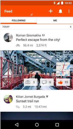
Millions of runners, cyclists and just active people use Strava to have a data record of their trainings, follow their progress, communicate with like-minded people as well as share pictures, stories and best moments of sports adventures with friends.
Game features:
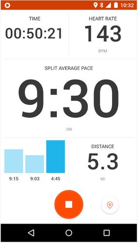
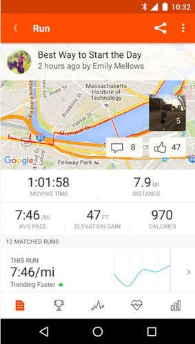
Free tracking of races, rounds and other trainings
Keep in touch with your friends and like-minded fellows
Synchronization with any devices
Like it? Share with your friends!
Supported operating systems:
Google Android 10.x, Google Android 4.0, Google Android 4.1, Google Android 4.2, Google Android 4.3, Google Android 4.4, Google Android 5.x, Google Android 6.x, Google Android 7.x, Google Android 8.x, Google Android 9.x
Similar Software:
OSMTracker for Android OSMTracker stands for OpenStreetMap Tracker. It allows you to track your journey and mark significant way points. Way points can be marked with a tag using a button, with a quick voice record, a text note or by taking a picture. The various button pages and layouts can be customized to suit your OpenStreetMap activities
Metosphere (Android) Metosphere Explore and create virtual objects around your physical location like messages, emergency alerts, events, news, reviews, games. View geospatial data from Wikipedia, Eventful, and Upcoming. Start a GeoBlog on your GPS-enabled phone.
This is the core Metosphere Android app
Yandex navigator Yandex navigator - is a useful application which will easily make the best route for you by means of GPS, taking into consideration traffic jams and other road situations. Voiced hints are available which will inform you on accidents or roads under repair. The application will offer several routes. During the dark part of a day night mode is available
Android Photo GeoTag Android Photo GeoTag - Take pictures with your mobile phone and incorporate the data of the geographical location. The application allows you to include in the photographs, data from the GPS receiver, along with a brief note. If you know the coordinates, not having the GPS receiver, you can also handwrite geographic data
Maps In My Pocket (MIMP) Maps In My Pocket - The main goal of this application is to allow its users to view maps, locate themselves, follow KML or GPX formatted tracks and getting directions from place to place.
What's New in This Release:
· New Icon
What's New in 1.4.3:
· Long press and long pinch concurrency on info bubble solved
Gps Toggle Widget Gps Toggle Widget - Gps Toggle Widget is a simple home screen widget that toggles Gps on/off very easily.
Widget Feature:
- Simple Gps- toggle widget (1x1).
- Select color as you wish. Color changes with state changes on the phone - when enabling or disabling
Location Manager Location Manager - This unique location app is best described with the following scenarios:
Scenario 1:
I live in an area where the Oregon, California, and Santa Fe Trails all passed through. There are signs everywhere saying, "The trails crossed here"
GPS Status GPS Status is an application which displays the information received from the phone's GPS receiver. In addition to the basic location information it can extract and display the state and location of each visible GPS satellite which is displayed on a simple sky view. The outer circle represents the horizon while the center corresponds to the zenith right above your head
GPSHunt GPSHunt - GPS application like a handheld GPS designed by hunters for hunters. You can use it in a hunting game where you use a GPS to hide and seek containers with other participants in the activity.
What's New in This Release:
· support APP2SD
What's New in 4.0:
· minor optimization
What's New in 3
Comments on Strava running and cycling GPS:
Comments not found
If you noted an error or download link is broken, please, report it via this page or use comments.
Strava running and cycling GPS is compatible with your device Xiaomi Black Shark 2 Dual SIM TD-LTE CN 128GB SKW-A0 (Xiaomi Skywalker)

")


")


")


