GPS Status & Toolbox - Be a GEEK: Get the most out of your phone. Raw GPS data at your fingertips.
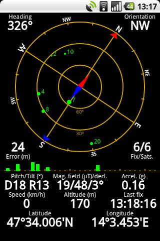
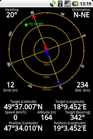
Display your GPS and sensor data: position and signal strength of satellites, accuracy, speed, acceleration, bearing.
Tools included: compass with magnetic and true north, leveling tool, mark or share your location and navigate back later.
Keep your GPS fast: reset it or download A-GPS data regularly for faster fixes.
What's New in This Release:
· Workaround for Nexus S issues.
· aGPS age is correctly displayed (in hours / days).
· Fixed a rounding error in location formatting.
· More instruments for Nexus 7.
· Enhanced landscape layout. All instruments are available in landscape mode, too!
Like it? Share with your friends!
Supported operating systems:
Google Android 1.0, Google Android 1.5, Google Android 1.6, Google Android 10.x, Google Android 2.0, Google Android 2.1, Google Android 2.2, Google Android 2.3, Google Android 3.0, Google Android 3.1, Google Android 3.2, Google Android 4.0, Google Android 4.1, Google Android 4.2, Google Android 4.3, Google Android 4.4, Google Android 5.x, Google Android 6.x, Google Android 7.x, Google Android 8.x, Google Android 9.x
Similar Software:
Earth Geo Magnetic Field Calculator 3D Earth Geo Magnetic Field Calculator 3D - Earth Geo Magnetic Calculator 3D used to estimate magnetic field at a given point on Earth, and in particular, to compute the magnetic declination from true north
Advanced Compass Advanced Compass - You are backpacking as part of an impromptu adventure trip. You are kind of lost and need to know the correct and accurate direction.
You need to say your daily prayers and need to know the exact direction
FillErUp Android application used to record vehicle mileage and calculate mpg
GPS Speed GPS Speed - Turn your Android phone into a digital speedometer! Nice Compass view + big digital speed view. You can use menu to switch m/s, MPH, KPH and Knot.
What's New in This Release:
· minor fix
What's New in 5.4:
· support APP2SD
What's New in 4
3D Measure 3D Measure - [3D Measure] It's a tool which perform non-contact distance measurement by using camera and hardware sensor of device. Quick estimation of the distance to any object and the object height and width. BEFORE MEASURE: 1. Set the camera height above the ground plane 2. Set the measure mode, height or width 3. Aim at the bottom of the object HOW TO MEASURE: 1
Elevation and Sea Depth Elevation and Sea Depth displays elevation and/or sea depth in direction of phone.In order to use it properly, hold your phone on flat surface and away from ferrous metal objects and electromagnetic fields
Super Compass Free Super Compass Free - Super Compass Free is a basic compass application that shows you which direction your phone is pointed. You can use Compass in all outdoor activities as you can think about - walking, sailing, hiking, climbing, camping, flying, reading a map and so much more
GeoLog GeoLog saves the sensors data (gps, accelerometer, magnetometer data, etc.) of your device to a log file and calculates the coverage of the site. The coverage is a ratio of the track covering area to the area of the site (expressed in percents)
Naver Maps Naver Maps - Smarter than ever! Experience Naver Map for Android. You can find the shortest way to get to your destination, using public transportation even it is far away. You can also search the information on the area around you easily and check whether you are heading to your destination correctly with GPS and compass
Other Software by developer «EclipSim Bt.»:
Hungarian for AnySoft Keyboard Kenyelmesen, magyarul irhat az Anysoft Keyboard segitsegevel. Magyar billentyűzet kiosztas es szotar AnySoftKeyboard-hoz. FIGYELEM! Ez egy kiegeszitő, ami csak az eredeti programmal egyutt műkodik. Onalloan nem!