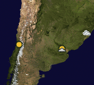
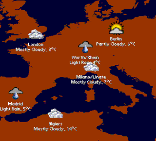
Current weather maps, reports and forecasts - This pack includes two weather maps containing 20 and 50 principal agglomerations of the world: Algiers, Ankara, Athens, Baghdad, Bangkok, Beijing, Berlin, Buenos Aires, Cairo, Caracas, Casablanca, Chennai (Madras), Chicago, Dallas-Fort Worth, Delhi, Dhaka, Guadalajara, Ho Chi Minh City, Hong Kong, Jakarta, Johannesburg, Karachi, Khartoum, Kinshasa, Lagos, Lima, London, Los Angeles, Madrid, Medellin, Metro Manila, Mexico City, Miami, Milan, Moscow, Mumbai (Bombay), Porto Alegre, Rhein-Ruhr North, Rio de Janeiro, Saint Petersburg, San Francisco-Oakland, Santiago (Chile), Seoul, Shanghai, Singapore, Sydney, Tehran, Tokyo, Toronto and Washington D.C.
These two maps require PrettyMap software installed and internet connection on your PDA.
Registered PrettyMap Full users can create weather maps with customized locations (e.g. cities of interest).
What's New in This Release:
· upgraded to conform with versions 4.x of PrettyMap
Like it? Share with your friends!
Supported operating systems:
Palm OS 3.x, Palm OS 4.x, Palm OS 5.x
Similar Software:
Harn Astrolabe Displays weather, religious calendar, sunrise and set, moonrise and set, and moon phase in a concise single-screen display, for any day from Nuzyael 1 715 to Morgat 30 734, according to the Harn rules (published by Columbia Games)
TreoCiel (Palm OS) TreoCiel (Palm OS) - Get your local weather charts on your smartphone, so you can view a whole week in a snap and also get detailed hourly forecasts for the next days. Charts make it easy to show to friends and colleagues
Weather Companion Pro Weather Companion Pro is a GPRS based high-end software that brings weather information from internet for all major cities in the world
PalmaryClock Wireless for Treo and Centro (German) PalmaryClock Wireless for Treo and Centro (German) is a powerful time management tool. All time handling functions are collected in one device! A nice clock with skins and backgrounds support also offers You unlimited quantity of independent alarms with MP3 support and an ability to start any program installed on your device
Weather Forecast Browser Weather Forecast Browser - Weather Forecast Browser (also known as WFBrowser) – is offline browser for weather forecast web sites. In current version all information gets from http://weather.yahoo.com. WFBrowser allows check forecast information in offline on closest 5 days
Weather Log 2002 Weather Log 2002 is a tinyByte weather data base for weather enthusiasts, students, gardeners, etc. You must have thinkDB 2.5 to run this program. This weather log has input fields for day, low, high, pressure, wind speed and direction, humidity, rain, snow, frost, cloud type and observations
xWeather xWeather - Tabbed interface for easy one hand navigation.
Profile manager to create, delete or rename profiles and track weather in multiple locations.
Nexrad radar and Satellite images, user configurable custom map urls.
Display weather alerts, watches and warnings
Weather Manager Weather Manager - With Weather Manager keep track of the current weather conditions and 5-day weather forecast for thousands of cities around the world with your Palm OS? device.
Weather Manager is a great travel companion. Check the weather on the road by using a Treo 600/650 or by connecting your Palm to a (wireless) modem or mobile phone
Other Software by developer «Maciej Komosinski»:
Little Sailor: sailboat, surfing and motorboat simulator Little Sailor
Take Little Sailor with you and learn basics of sailing! See how wind force affects the sail and test your skills against AI opponents in a yacht race. Learn how to trim the sails to make the most use of wind energy
PrettyMap Full View maps of Earth and other planets with PrettyMap! See day and night areas, learn geography, enjoy 3D elevation surfaces, measure distances and create your own maps with special places!
Europe Elevation Maps Europe Elevation Maps - This free pack contains high resolution elevation map for Europe, divided into 2 smaller pieces. Each tile covers the projected area of 40°x50°, and contains almost 29 million of samples (one sample per square kilometer).
51 countries lie in the area covered by this pack
PrettyMap Basic View maps of Earth and other planets with PrettyMap! See day and night areas, learn geography, enjoy 3D elevation surfaces, measure distances and create your own maps with special places!
Little Sailor (iPhone/iPad) Little Sailor (iPhone/iPad) - Little Sailor is a highly realistic sailing and motorboat simulator. Take Little Sailor with you and learn basics of sailing! See how wind force affects the sail and test your skills against AI opponents in a yacht race. Learn how to trim the sails to make the most use of wind energy. Discover when there is a risk of capsizing
Free Earth Elevation Map for PrettyMap/PrettyEarth Earth Elevation Map for PrettyMap/PrettyEarth - This is a medium-resolution, free Earth elevation map for PrettyMap and PrettyEarth. It contains one elevation sample per 4 km, approximately.
Note: large file (16 MB download, 55 MB after installing).
Note for PrettyEarth users: this map will be installed to Program FilesPrettyMapmaps
PrettyMap View maps of Earth and other planets with PrettyMap! See current day and night areas, learn geography with the quiz, enjoy 3D elevation relief, measure distances, edit locations!


")


")


")


