CelestNav turns your PalmOS handheld into a full-featured calculator for celestial navigation.
· computation of fix position from celestial observations.
· perpetual nautical almanac for navigational stars, Moon, Sun, planets.
· Mercator and Great Circle sailing computation.
· computes range, height, sextant angle for lighthouses and other terrestrial objects.
· twilight, rise, set, meridian passage computation.
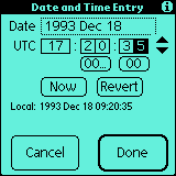
· automatic timing of sextant observations and adjustment to UTC.
· handles backsights, non-standard atmospheric conditions, and more.
· sight reduction screen with the functionality found in publications H.O. 229 and H.O. 249.
· continuously updated dead reckoning position.
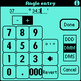
· "finger-friendly" data entry screens for celestial observations, angles, dates, and times.
· 10 days trial
Like it? Share with your friends!
Supported operating systems:
Palm OS 3.x, Palm OS 4.x, Palm OS 5.x
Similar Software:
Gobzi Gobzi - Calculates your VFR cross country time on route, fuel buring time remaining in gallons/liters and flight time.
Calculates cross wind and head/tail wind component,wind correction angle, time between check points and ground speed, with simple push of a few buttons
Google Maps Mobile Google Maps Mobile-Take the power of Google Maps with you on your mobile phone.
Real-time traffic - See where the congestion is, and estimate delays in over 30 major US metropolitan areas.
Detailed directions - Whether you plan to walk or drive, your route is displayed on the map itself, together with step-by-step directions
TNR TNR is a powerful radius to chamfer to radius profiling app. Anyone with a CNC can benefit from the g-code programming ease. The graphical interface is intuitive and easy to understand. Complex contour programming has never been easier!
What's New in This Release:
· New graphical interface! Updated formulas
NitroxBasic NitroxBasic - Program to calculate maximum Depth (MOD), air depth (EAD) for Nitrox dives.
Also calculates tank blending of air and O2. Units in imperial or metric.
Programm zur Berechnung von maximaler Tiefe (MOD), Vergleichtiefe (EAD), Nullzeit und Flaschenmix f¼r Tauchgaenge mit Nitrox
SunFly SunFly - allows computation of sunrise and sunset observed from an aircraft.
With SunFly, mainly an application for aviators, you can exactly predict not only time but also the position of sunrise or sunset.
Insert two waypoints with its coordinates and the respective estimated time over (ETO), the flight level and SunFly does the rest
Odometron Odometron - A basic freeware gas usage log and calculator for Palm OS handhelds. Supports up to 16 concurrent vehicles. Distance, volume, and currency are purposely referred to without specifying units so the application can be more universal. If you live in the US you can apply miles, gallons, and USD - if you live in Europe use kilometers, liters, and Euros
NM Log NM Log - This program is designed to keep track the nautical miles / NM for all your boats.
· Keep track the total that you are spent.
· Calculate the average L/NM, Price/L
· Purge all records which are older than 31 days.
· Filtering the records by specific boat or fuel type
NavAids NavAids is a handy application to compute true course, distance and ETE between two geographic positions.
The shipped database contains more than 600 geographic locations in metropolitan France, including radio navigation aids (VOR, NDB, LOCATOR, ...) and visual report points of hundreds of airfields
Distance (Deutsch) by Hans Distance (Deutsch) by Hans - Distance computes the geodesic distance between two points on the surface of the Earth to an accuracy of about ±50 meters.
This is the German version.
What's New in This Release:
· Extended input accuracy to .01"
· Display of calculated distances to .0001 accuracy
GreatCircle (Palm OS) GreatCircle (Palm OS) is an application for Palm OS based handhelds to compute the greatcircle distance and bearing angle between two locations on the Earth.
GreatCircle is used in conjunction with the GeoDB database application.
GreatCircle is the computation engine and GeoDB holds the location database.
TheGreatCircle archive (gc12
Other Software by developer «Mobile Geographics LLC»:
MG229 MG229 is a free tool for celestial navigation. It performs calculations similar to those tabulated in the 6 volumes of H.O. 229
Using MG229
Enter dead reckoning position, without rounding, for DR.
Enter celestial body's GHA (Greenwich Hour Angle) and declination (you must obtain these values from the Nautical Almanac)
iqTest iqTest - Text-only display of the position, velocity, time, and status information from the Garmin iQue3600. Written to answer some questions that arose on the garminPDA mailing list. Shows all error and velocity components, and elevation referenced to either MSL or WGS-84 datum
IQ Booster IQ Booster - enjoy the full potential of the GPS receiver in your Garmin iQue series PDA with IQ Booster.
Export waypoints from your iQue 3600 to your desktop computer
Keep a log of your trip and map it on your desktop computer
Connect your iQue 3600 to other navigation electronics via NMEA
IQ Booster gives you the GPS functions you need for serious mapping


 by Hans")
")


