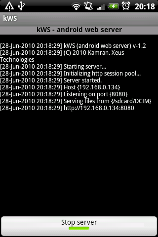
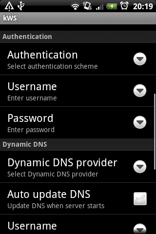
kWS is a lightweight and fast web server especially designed for Android devices. It can be used to host websites and to serve files over HTTP. kWS implements HTTP-1.0 with basic & digest authentication schemes and supports dynamic DNS updates.
What's New in This Release:
· Fixed issues arising from internal Apache Harmony bugs.
· Fixed crash issues reported from Droid and Nexus One.
· Some minor updates
Like it? Share with your friends!
Supported operating systems:
Google Android 10.x, Google Android 2.1, Google Android 2.2, Google Android 2.3, Google Android 3.0, Google Android 3.1, Google Android 3.2, Google Android 4.0, Google Android 4.1, Google Android 4.2, Google Android 4.3, Google Android 4.4, Google Android 5.x, Google Android 6.x, Google Android 7.x, Google Android 8.x, Google Android 9.x
Similar Software:
Linux Deploy Linux Deploy - is an application for installation of a standard Linux operating system. The utility has an open source code which allows making changes to all available components. All internal programs are started together with processes of a regular system. This provides stable work of the device
Access 2003 macros Access 2003 macros - If you have been working in Access for some time and did not add much automation to your database you probably are not satisfied. Your database needs more. It is time to write some VBA code.
Not everything you need to do with your database should be accomplished via code
ActionScript3 Reference The ActionScript 3.0 Language Reference is a reference manual for the application programming interfaces (APIs) for Adobe Flash Professional, Flash Player and Adobe AIR.
This version includes ActionScript classes, methods, and properties that support the Adobe AIR runtime environment
Add-on Compatibility Reporter Add-on Compatibility Reporter - Help Mozilla make sure your favorite add-ons get updated for upcoming Firefox releases by using this extension to report whether they still work or are having some issues with alpha and beta releases
mBS Mobile Android mBS Mobile Android is a fully integrated Mobile OSGi 4.1 runtime eval stack for Android.
Key features:
Support for W3C Widgets (run Web Widgets on Android)
Use OSGi Services with JavaScript from browser
Remote Management of Apps
Integration between Android apps and OSGi Developer SDK available
Instant Mobile Website Creation Instant Mobile Website Creation - Software for Instant Mobile Website Creation. Download this free software and create an unlimited number of mobile websites and be part of the mobile revolution that takes place on the internet right now. The software allows you to produce as many pages and subpages as you like
Web Server Web Server- Simple Web Server. Photo Calendar function is provided in the first version. Consideration of security - Only 1 access is connectable from outside - Basic authentication - A port number is set up at random The local network of WiFi connection is recommended
Learn Software Testing Learn Software Testing - Testing is executing a system in order to identify any gaps, errors, or missing requirements in contrary to the actual requirements. This tutorial will give you a basic understanding on software testing, its types, methods, levels, and other related terminologies
CSS Reference Complete CSS reference with syntax, examples, browser support, and more
Other Software by developer «Xeus Technologies»:
K2 K2 allows you to send your webtexts, provided by your mobile operator, directly using your Android smartphone just like regular SMS