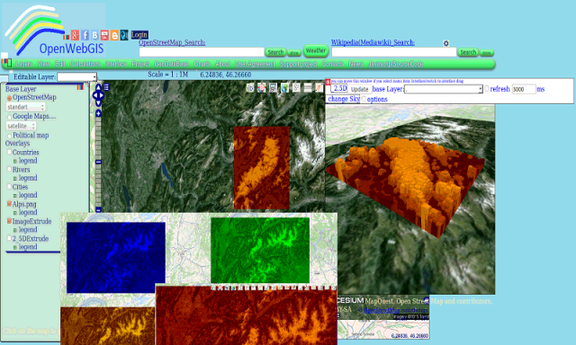
OpenWebGIS - OpenWebGIS is created for everyone who wishes to see and use a new free&open Geographic Information System(GIS). Please make your comments and suggestions. In this GIS you can use the extensive mathematical functionality to calculate and analyze your data. Using OpenWebGIS you will get a GIS at your disposal, it may be similar in functionality to some desktop GIS. Please support this project. The OpenWebGIS for Android has online and local version. In local version, you can use OpenWebGIS without having to connect to the server of OpenWebGIS and even without Internet connection. In local version, some functions do not work, but in future there will be the modification of these functions for the local version. The OpenWebGIS blog (http://openwebgisystem.blogspot.com/) provide a lot of information about possibilities for users' data operating. Full list of articles about OpenWebGIS: http://openwebgisystem.blogspot.com/2015/08/list-of-articles-about-openwebgis-in.html
Like it? Share with your friends!
Supported operating systems:
Google Android 10.x, Google Android 3.0, Google Android 3.1, Google Android 3.2, Google Android 4.0, Google Android 4.1, Google Android 4.2, Google Android 4.3, Google Android 4.4, Google Android 5.x, Google Android 6.x, Google Android 7.x, Google Android 8.x, Google Android 9.x
Similar Software:
Virtual/Augmented Reality Package Virtual/Augmented Reality Package - The virtual reality package is a library for virtual/augmented reality applications.
The library is currently under development and at the current stage, there is much work left to be done
CroakDroid Lite CroakDroid Lite is an unofficial Client application for the Hoptoad Error Tracking Service. It can be used to retrieve errors and display details about them. Requires an existing account and Auth Token.
This app is not officially associated with Hoptoad in any way. The name and logos for Hoptoad are trademarks of thoughtbot, inc
Linux GTKSharp Programming Linux GTKSharp Programming - GTKSharp Tutorial 'Looks Good! Feels Good'! For any application, we feel it's good when it 'Looks' good
Learn Map Reduce Learn Map Reduce - MapReduce is a programming paradigm that runs in the background of Hadoop to provide scalability and easy data-processing solutions. This tutorial explains the features of MapReduce and how it works to analyze Big Data
S_W Development Life Cycle S_W Development Life Cycle - This tutorial is designed for the readers pursuing education in software development domain, Software Testing aspirants and all enthusiastic readers. Software engineering is an engineering branch associated with development of software product using well-defined scientific principles, methods and procedures
Learn Jackson Learn Jackson - Jackson is a very popular and efficient Java-based library to serialize or map Java objects to JSON and vice versa. Learn Jackson uses a simple and intuitive way to explain the basic features of Jackson library API and how to use them in practice. Learn Jackson will be useful for most Java developers, regardless of whether they are beginners or experts
RTMP Dump RTMP Dump is a tool to download rtmp:// and rtmpe:// streams
Learn IPv6 v2 Learn IPv6 v2 - This tutorial has been designed to help beginners understand the basic concepts of IPv6 required to work with any TCP/IP based protocols. After completing this tutorial you will find yourself at a moderate level of expertise of IPv6 from where you can take yourself to next levels
Comments on OpenWebGIS:
Comments not found
If you noted an error or download link is broken, please, report it via this page or use comments.
OpenWebGIS is compatible with your device ZTE PF112