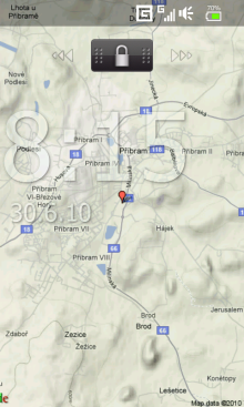
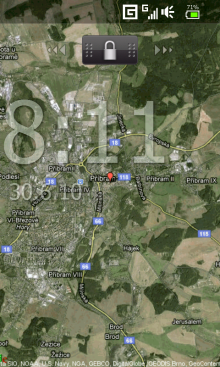
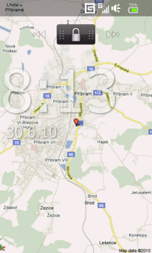
WMM Wallpaper Map locates the coordinates without the use of GPS (like Google Maps), downloads the map from GoogleMaps and sets it as background.
· Supports Today, Sense / TouchFlo, Co0kie's home
· Can change the map zoom and map type (4)
· You can view location marker
· Supported resolutions: SQVGA, QVGA, QVGA L, VGA, WVGA.
What's New in This Release:
· Support S2U2
· Skip update if is No Service
Like it? Share with your friends!
If you got an error while installing Themes, Software or Games, please, read FAQ.
Supported operating systems:
Windows Mobile 6 Classic, Windows Mobile 6 Professional, Windows Mobile 6.1 Classic, Windows Mobile 6.1 Professional, Windows Mobile 6.5 Professional
Similar Software:
Fizz Traveller .Fizz { font-family: Arial; font-size: 8pt; }.style1 { font-family: Arial,Helvetica,sans-serif; color: rgb(51, 51, 51); font-size: 12px; }
Fizz Traveller 3.0 is the next generation of the Award Winning Fizz Traveller program. With Fizz Traveller 3
Metro Metro helps you find your way in the public transport systems (subway, bus, trams, ...) in more than 400 cities around the world. FREE, FAST & ACCURATE. Simply enter you start and end stops, hit the "Go" button and the program finds the fastest route
MapTexterer MapTexterer - MapTexterer allows you to create text based GPS maps. When you get a GPS lock then you can create a new map and enter text for the area. When you save the text the map is downloaded and the text and GPS is appended to the end of the map with current GPS.
This program requires that you have both the 'BeanDLL
MailGoogling MailGoogling allows you to enter a ZIP code or partial ZIP code and displays the ZIP code map and location
GPSed Pro GPSed - Mapping Your Impressions
GPSed is a service for trip tracking from mobile. In real time tracks are traced on Google maps and stored in an online archive. With a simple geotagging feature it is possible to pin photos to a map precisely at a place they were taken
PathAway GPS SE PathAway GPS SE - GPS Navigation using your own maps! Convert any digital map, for use on your Pocket PC. Then, attach a compatible GPS (via bluetooth, cable, snap-on, or card) to your handheld, and you have a powerful GPS Moving Map navigation system
Map of Toulouse (French) / France for City Advisor Map of Toulouse (French) / France for City Advisor - Toulouse / France map in French for City Advisor. It has 2 metro lines.
1. Download the map (zip file)
2. Extract the files in /CityAdvisor/maps
3. Open CityAdvisor -> Maps icon -> Menu -> Refresh
4
BikeDashboard BikeDashboard- This application provides training assistance (through graphs and stats) + navigation help (with moving maps and GPX file import & export) for mountainbike and roadbike enthusiasts.
BikeDashboard Features:
* Keep a track of their achievements:
o Where they have been.
o How long.
o How fast
Locle Locle is a mobile application that lets users see where their friends and family are without the need for GPS. Wherever you are, always find out where people are and meet them for lunch, drinks or whatever you want to do. Just make sure you don't miss out on anything
Traffic Vizzion (12 month subscription) IMPORTANT: Do not operate this product while driving; park the vehicle first. It is your sole responsibility to place, secure and use your mobile device in a manner that ensures safe driving
Other Software by developer «MikyWoW»:
WMM Lamp Simple flashlight application for Windows Mobile
WMM Wallpaper Changer WMM Wallpaper Changer - This program can automatically change the wallpaper based on time


 / France for City Advisor")


")

