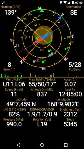
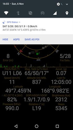
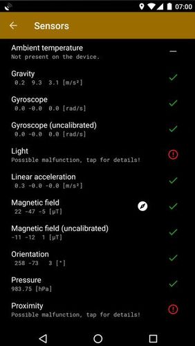
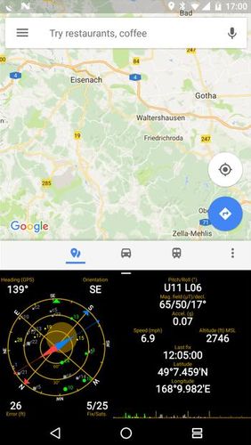
GPS status & toolbox - is a very useful program for working with GPS. This utility is aimed at viewing GPS condition and settings. It can display all data of a sensor and GPS: positions and satellite signal power, accuracy, speed, acceleration, height, step and even battery status.
Game features:
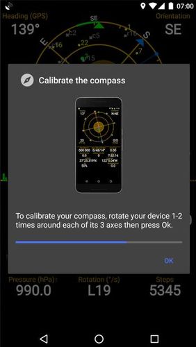
Magnet compass with accurate north
All data of a sensor and GPS
Fast search
Simple and comprehensive interface
Loading video...
Like it? Share with your friends!
Supported operating systems:
Google Android 4.1, Google Android 4.2, Google Android 4.3, Google Android 4.4, Google Android 5.x, Google Android 6.x, Google Android 7.x, Google Android 8.x
Similar Software:
Maps In My Pocket (MIMP) Maps In My Pocket - The main goal of this application is to allow its users to view maps, locate themselves, follow KML or GPX formatted tracks and getting directions from place to place.
What's New in This Release:
· New Icon
What's New in 1.4.3:
· Long press and long pinch concurrency on info bubble solved
GPSLocatorFree GPSLocatorFree - Always know where you are and where to go with GPS. Find for the closest Wal-Mart or restaurant. View your location. View a map picture of your location , street view, satellite view, zoom +. Always know where you are. Share your location with your friends
Back2It Back2It is not just a car locator.
With one click, you may mark places like:
- parking lots
- favorite restaurants
- museums
- theaters
- public park
...
and 1 click to go back with GPS navigation on Google Map.
Switch to Google Map for route
iTrack iTrack is an application for tracking your friend's location in real time. You and your friend must both install this application. Click menu to show current online users; Click your friend and make a request. Your friend will be notified and respond to your request. The map will be updated in real time if your friend allows tracking
Mapacha Mapacha - What you can do with Mapacha? You can localize your friends and family in a map. See where they are if your are meet with them and know how much they last for arrive. If you are worried about your sons or couple and see / track where they are. Also you can localize people from your country if you are abroad. What about privacy? Use it as you want
wheredroid wheredroid is a simple application to display your coordinates from the GPS receiver: latitude, longitude, heading, speed, number of satellites used and (it's its peculiarity) altitude and accuracy. It is quite usable as an altimeter and a compass.
What's New in This Release:
· fixes a bug inverting East with West on some displays
What's New in 1.4
DondeEsta - ultimate SMS mobile tracking system! DondeEsta - ultimate SMS mobile tracking system! - LOCATE YOUR FAMILY SIMPLE SENDING SMS
Install the application in the mobile to be located (i.e. your kid's mobile)
Mobile tracking for family safety.
Locate your children.
Locate elderly.
Locate for your own safety.
Easily alert your family when you are in a trouble!
DondeEstaTM brings peace of mind
Current Location Finder Current Location Finder - Current Location finder which can be used to locate your location with the aid of a live satellite map you can dynamically (real time) determine ... Use the live satellite maps
TomTom Western Europe for Android TomTom Western Europe for Android - TomTom Western Europe is a turn-by-turn GPS navigator for Android devices. The app includes accurate offline maps, so you can find your way anywhere, even without an internet connection
Comments on GPS status & toolbox:
rob:
Nice
Date: 7 Nov 21
If you noted an error or download link is broken, please, report it via this page or use comments.
GPS status & toolbox is compatible with your device ZTE Source N9511


")


