Platforms: iPhone, iPad, iPod Touch, Apple iPhone OS
Categories: Travel & Navigation
Upload date: 26 Nov 11
Developer: Visual IT
License: Freeware
Downloads: 81
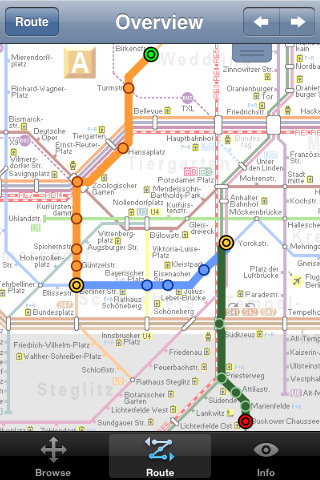
Berlin Metro 09 - The "Berlin Metro 09" application is a superb interactive map and route planner for the Berlin Metro (U-Bahn) and Suburban rail (S Bahn) systems. You can also use your inbuilt GPS (will also work with iPod Touch devices) to accurately locate and see the nearest transportation stop and distance to it. This application is one in a worldwide series of "Tube" maps from Visual IT who have been producing public transportation maps for mobile devices for many years.
SPONSORSHIP
This product is brought to you free of charge through the sponsorship of the Berlin transport authority VBB (Verkehrsverbund Berlin-Brandenburg).
MAP
Tap on the map for station information, use the inbuilt search feature or choose from a list of locations. Places of interest, museums, parks, shops, universities, theatres, etc, are also included. The route planner will automatically suggest the nearest station to any place of interest you select.
INTERNET CONNECTION
The map and routing does not require an internet connection and you will not be charged data connection fees. This also means the application runs successfully underground and on an iPod Touch. The only feature that requires an internet data connection is the “Live Info” which is optional and if used only requires a small amount of data.
ROUTING
Does not require an internet connection and will always be available to display a clear and detailed view of the city transport systems, plus list and animate the optimum route for your journey. Provides the fastest route calculations of any mobile routing application (virtually instantaneous) using actual published journey times with the ability to select the quickest route or the route with the fewest changes.
Comprehensive details of your planned route are provided, including changes, directions of travel, number of stops, predicted journey times, etc. Uniquely this application gives you “direction”, “towards” and “service frequency” information (not available on any other offline journey planner) for example “Take the U2 line (Southbound) towards Kaiserdamm for 4 stops. Service runs every 7 minutes” which is essential when finding the correct platform and connection. Also given are alternatives for each leg of the journey.
Like it? Share with your friends!
If you got an error while installing Themes, Software or Games, please, read FAQ.
Supported operating systems:
Apple iOS 10.x (iPad), Apple iOS 10.x (iPhone), Apple iOS 11.x (iPad), Apple iOS 12.x (iPad), Apple iOS 12.x (iPhone), Apple iOS 4.0.x (iPhone), Apple iOS 4.0.x (iPod Touch), Apple iOS 4.2.x (iPad), Apple iOS 4.2.x (iPhone), Apple iOS 4.2.x (iPod Touch), Apple iOS 4.3.x (iPad), Apple iOS 4.3.x (iPhone), Apple iOS 4.3.x (iPod Touch), Apple iOS 5.0 (iPad), Apple iOS 5.0 (iPhone), Apple iOS 5.0 (iPod Touch), Apple iOS 6.0 (iPad), Apple iOS 6.0 (iPhone), Apple iOS 6.0 (iPod Touch), Apple iOS 7.0 (iPad), Apple iOS 7.0 (iPhone), Apple iOS 7.0 (iPod Touch), Apple iOS 8.x (iPad), Apple iOS 8.x (iPhone), Apple iOS 8.x (iPod Touch), Apple iOS 9.x (iPad), Apple iOS 9.x (iPhone), Apple iOS 9.x (iPod Touch), Apple iPhone OS 2.x, Apple iPhone OS 2.x (iPod Touch), Apple iPhone OS 3.1.x, Apple iPhone OS 3.1.x (iPod Touch), Apple iPhone OS 3.2.x (iPad)
Similar Software:
Hotels.com for iPhone Hotels.com for iPhone - Hotels.com allows you to quickly find a hotel and book a room right from your iPhone. The app includes a database of more than 150,000 hotels from 200 countries, complete with photos, ratings and reviews from customers.
The application allows you to search for hotels nearby or at the specified destination, and view their location on a map
New York Offline Map & Guide by Tripomatic New York Offline Map & Guide by Tripomatic - New York Offline Map & Guide by Tripomatic is a travel guide and trip planner for iPhone.
The app allows you to create your itinerary by choosing the places you want to visit.
The software comes with an offline map of New York, so you can use it even without an internet connection
Trip Journal (iPhone) Trip Journal (iPhone) is the #1 Google Awarded Travel Application with the best trip tracking, recording, documenting and sharing features currently available for iPhone.
Trip Journal allows you to document vacation experiences and share them with your friends and family
Agoda for iPhone/iPad Agoda for iPhone/iPad - Smarter hotel booking just got smarter.
agoda.com - a world of hotels in the palm of your hand.
The agoda.com advantage. To go.
· Over 160,000 hotels worldwide
· 1,000,000+ hotel reviews every year
· Free stays with agoda
Priceline.com: Hotels, Flights & Rental Cars Priceline.com: Hotels, Flights & Rental Cars - Power up priceline.com's Hotel Negotiator app and let the Priceline Negotiator, William Shatner, find you last-minute Name Your Own Price hotel rooms that you can book at savings of up to 50%.
· Choose a city and see multiple winning hotel bids for the hotel star levels and parts of the city you want
AUSTRALIA & OCEANIA REGION ATLAS & TRAVEL SEARCH ENGINE AUSTRALIA & OCEANIA REGION ATLAS & TRAVEL SEARCH ENGINE - ATLAS & TRAVEL SEARCH ENGINE
· Trip planning tool.
· GPS Companion.
· ZOOM TOUCH capability with 2-fingers.
· RE-CENTER TOUCH capability with 1-finger.
· Portrait or landscape views.
· Take a picture of your screen
FlightTrack Pro FlightTrack Pro - the best flight tracking app out there. Get push alerts, real-time flight itinerary updates, automatic synching, and beautiful, zoomable maps that work offline. Flight cancelled? It will even help you find alternate flights.
FlightTrack Pro works seamlessly with TripIt. Forward your airline confirmation emails to plans@tripit
CityTransit - Official NYC Subway Maps CityTransit - Official NYC Subway Maps - CityTransit uses GPS to help you find the nearest subway station and integrates with the Maps application so you can quickly get to the nearest subway station. Built-in service advisories download data from the MTA's website so you can plan your weekend trips in advance
North America - iGO primo Lite North America - iGO primo Lite - iGO primo Lite is a free route planner and map viewer built upon the experienced iGO Engine employed by GPS navigation devices all over the world. The software uses accurate offline maps which can be used anywhere. This way you don't have to worry about losing your internet connection, and you avoid unnecessary data traffic costs
Weekend Trips Near San Antonio Weekend Trips Near San Antonio - GPSmyCity.com's day trips application is a powerful tool for planning your weekend getaways. With a well researched list of weekend getaway spots around the city you live in and the powerful navigation features built-in, you will never be bored on a weekend.
This app works on iPhone, iPad and iPod Touch
Other Software by developer «Visual IT»:
Tube London (2009 Edition) Tube London (2009 Edition) - Tube London
The ideal map for the traveller who needs to get around London using the underground system and would like to know just exactly where they are.
The map geographically locates all the central stations, making it much more informative than the official topological map
Berlin Metro by Zuti Berlin Metro by Zuti - The new Berlin Metro map makes it easy to travel in and around the city using the Metro (U-Bahn) Suburban Rail (S-Bahn) and Tram (MetroTram and Straßenbahn) systems
Tube Montreal (UIQ) Tube Montreal (UIQ) - Our award winning and highly acclaimed application that guides you around the metro system of Montreal is now available for your Symbian UIQ phone.
An essential addition to your P800 / P900 / P910 if you travel in or around this city.
· A detailed clear colour map of the Montreal metro system fully scrollable
Tube 2 New York City (UIQ3) Tube 2 New York City (UIQ3) - This map package for Tube 2 consists of a fully scrollable detailed map of the New York City MTA subway system.
Plan journeys on this system, list details of the quickest routes and see a superb animated display of your journey tracking around the system map
Vienna Metro 10 Vienna Metro 10 - This Zuti application contains a visually unique map of Vienna's transport systems and a superb animated journey planner to help you get around the Metro (U-Bahn), Suburban Rail (S-Bahn) and Tram (Stragenbahn)
Manchester Mini A-Z Manchester Mini A-Z - "Manchester Mini A-Z" is a digital rendition of the famous Geographers Company Mini A-Z Atlas for Manchester
San Francisco Metro for iPad by Zuti San Francisco Metro for iPad by Zuti - The new San Francisco Metro 10 application makes it easy to travel in and around the city using the Metro (BART), Streetcar, Light Rail(MUNI), Ferry and Presidio shuttle bus services
Rough Guides Map Paris Rough Guides Map Paris... These guides are a series of fantastic interactive maps.
Produced in conjunction with the premier travel publisher Rough Guides.
Discover and explore Paris using full colour interactive linked maps, in this simple to use PDA version of The Rough Guides Paris
Tube Munich (Series 60) Tube Munich (Series 60) - Our highly acclaimed Tube application that guides you around the complex metro system of Munich is now available for your Series 60 Symbian powered phone. An essential addition to your phone for locals and tourists alike.
· A detailed clear colour map of the Munich metro (S-Bahn/U-Bahn) system fully scrollable
Tube Madrid (Series 60) Tube Madrid (Series 60) - Our highly acclaimed Tube application that guides you around the complex metro system of Madrid is now available for your Series 60 Symbian powered phone. An essential addition to your phone for locals and tourists alike.
· A detailed clear colour map of the Madrid metro system fully scrollable.
· Quick find station utility


")


")

")
")


")
")